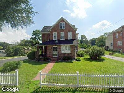
1072 Newark Rd Toughkenamon, PA 19374
Estimated Value: $318,000 - $354,000
3
Beds
1
Bath
1,820
Sq Ft
$186/Sq Ft
Est. Value
About This Home
This home is located at 1072 Newark Rd, Toughkenamon, PA 19374 and is currently estimated at $338,837, approximately $186 per square foot. 1072 Newark Rd is a home located in Chester County with nearby schools including Kennett Middle School, Kennett High School, and Avon Grove Charter School.
Ownership History
Date
Name
Owned For
Owner Type
Purchase Details
Closed on
Mar 27, 2017
Sold by
Dabundo Dominic V and Dabundo Linda
Bought by
Sellers Jennifer Dabundo
Current Estimated Value
Purchase Details
Closed on
Apr 3, 2000
Sold by
Dabundo Susie M and Dabundo Dominic V
Bought by
Dabundo Dominic V and Dabundo Linda
Create a Home Valuation Report for This Property
The Home Valuation Report is an in-depth analysis detailing your home's value as well as a comparison with similar homes in the area
Home Values in the Area
Average Home Value in this Area
Purchase History
| Date | Buyer | Sale Price | Title Company |
|---|---|---|---|
| Sellers Jennifer Dabundo | -- | None Available | |
| Dabundo Dominic V | -- | -- |
Source: Public Records
Mortgage History
| Date | Status | Borrower | Loan Amount |
|---|---|---|---|
| Previous Owner | Dabundo Dominic | $49,000 |
Source: Public Records
Tax History Compared to Growth
Tax History
| Year | Tax Paid | Tax Assessment Tax Assessment Total Assessment is a certain percentage of the fair market value that is determined by local assessors to be the total taxable value of land and additions on the property. | Land | Improvement |
|---|---|---|---|---|
| 2024 | $4,995 | $124,720 | $28,840 | $95,880 |
| 2023 | $4,828 | $124,720 | $28,840 | $95,880 |
| 2022 | $4,757 | $124,720 | $28,840 | $95,880 |
| 2021 | $4,709 | $124,720 | $28,840 | $95,880 |
| 2020 | $4,619 | $124,720 | $28,840 | $95,880 |
| 2019 | $4,557 | $124,720 | $28,840 | $95,880 |
| 2018 | $4,486 | $124,720 | $28,840 | $95,880 |
| 2017 | $4,394 | $124,720 | $28,840 | $95,880 |
| 2016 | $495 | $124,720 | $28,840 | $95,880 |
| 2015 | $495 | $124,720 | $28,840 | $95,880 |
| 2014 | $495 | $124,720 | $28,840 | $95,880 |
Source: Public Records
Map
Nearby Homes
- 112 Reese St
- 1003 Newark Rd
- 1265 W Baltimore Pike
- 110 Daniel Dr
- 1 Hiview Dr
- 413 Bucktoe Rd
- 100 Declan Unit HAWTHORNE
- 100 Declan Unit MAGNOLIA
- 100 Declan Unit SAVANNAH
- 100 Declan Unit NOTTINGHAM
- 8841 Gap Newport Pike
- 162 Bancroft Rd Unit CARLTON GRND
- 162 Bancroft Rd Unit CARLTON
- 162 Bancroft Rd Unit SUTTON
- 162 Bancroft Rd Unit SG
- 100 Fernwood Dr
- 208 Honey Locust Dr
- 222 Honey Locust Dr
- 250 Kestrel Ct
- 109 Ronway Dr