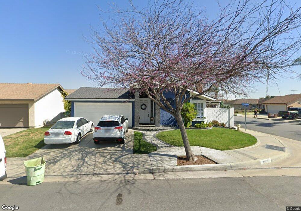
10738 Thomas Cir Cypress, CA 90630
Estimated Value: $973,000 - $1,045,000
3
Beds
2
Baths
1,474
Sq Ft
$685/Sq Ft
Est. Value
About This Home
This home is located at 10738 Thomas Cir, Cypress, CA 90630 and is currently estimated at $1,010,284, approximately $685 per square foot. 10738 Thomas Cir is a home located in Orange County with nearby schools including Cerritos Elementary School, Orangeview Junior High, and Western High School.
Ownership History
Date
Name
Owned For
Owner Type
Purchase Details
Closed on
Feb 5, 2026
Sold by
Miner Elizabeth A
Bought by
Elizabeth A Miner Trust and Miner
Current Estimated Value
Purchase Details
Closed on
May 14, 1999
Sold by
John Napier and John Margaret
Bought by
Miner Ronald L and Miner Elizabeth A
Home Financials for this Owner
Home Financials are based on the most recent Mortgage that was taken out on this home.
Original Mortgage
$192,000
Interest Rate
6.84%
Create a Home Valuation Report for This Property
The Home Valuation Report is an in-depth analysis detailing your home's value as well as a comparison with similar homes in the area
Home Values in the Area
Average Home Value in this Area
Purchase History
| Date | Buyer | Sale Price | Title Company |
|---|---|---|---|
| Elizabeth A Miner Trust | -- | None Listed On Document | |
| Miner Ronald L | $240,000 | Commonwealth Land Title |
Source: Public Records
Mortgage History
| Date | Status | Borrower | Loan Amount |
|---|---|---|---|
| Previous Owner | Miner Ronald L | $192,000 | |
| Closed | Miner Ronald L | $24,000 |
Source: Public Records
Tax History
| Year | Tax Paid | Tax Assessment Tax Assessment Total Assessment is a certain percentage of the fair market value that is determined by local assessors to be the total taxable value of land and additions on the property. | Land | Improvement |
|---|---|---|---|---|
| 2025 | $4,641 | $396,202 | $277,517 | $118,685 |
| 2024 | $4,641 | $388,434 | $272,076 | $116,358 |
| 2023 | $4,521 | $380,818 | $266,741 | $114,077 |
| 2022 | $4,429 | $373,351 | $261,510 | $111,841 |
| 2021 | $4,470 | $366,031 | $256,382 | $109,649 |
| 2020 | $4,409 | $362,278 | $253,753 | $108,525 |
| 2019 | $4,288 | $355,175 | $248,777 | $106,398 |
| 2018 | $4,228 | $348,211 | $243,899 | $104,312 |
| 2017 | $4,082 | $341,384 | $239,117 | $102,267 |
| 2016 | $4,063 | $334,691 | $234,429 | $100,262 |
| 2015 | $4,013 | $329,664 | $230,908 | $98,756 |
| 2014 | $3,808 | $323,207 | $226,385 | $96,822 |
Source: Public Records
Map
Nearby Homes
- 6490 Carolina Cir
- 10700 Knott Ave
- 10756 Knott Ave
- 10748 Knott Ave
- 10720 Knott Ave
- 7100 Cerritos Ave Unit 86
- 7100 Cerritos Ave Unit 85
- 10684 Bell St
- 3580 W Sweetbay Ct Unit B
- 7129 Cerritos Ave Unit 7
- 10305 Eudora Ave
- 6584 Capers Way
- 7081 Fulton Way
- 11271 Lowell Ct
- 7085 Fulton Way
- 11254 Jamaica St
- 11268 Morgen Way
- 3532 W Stonepine Ln Unit B
- 3515 W Stonepine Ln Unit D
- 6842 Amelia Way
- 10728 Thomas Cir
- 10749 Charles Cir
- 10718 Thomas Cir
- 10739 Charles Cir
- 6636 Walnut St
- 6646 Walnut St
- 10729 Charles Cir
- 6626 Walnut St
- 10737 Thomas Cir
- 6656 Walnut St
- 10708 Thomas Cir
- 10727 Thomas Cir
- 6616 Walnut St
- 10719 Charles Cir
- 6666 Walnut St
- 10717 Thomas Cir
- 6606 Walnut St
- 10698 Thomas Cir
- 10709 Charles Cir
- 6676 Walnut St
Your Personal Tour Guide
Ask me questions while you tour the home.