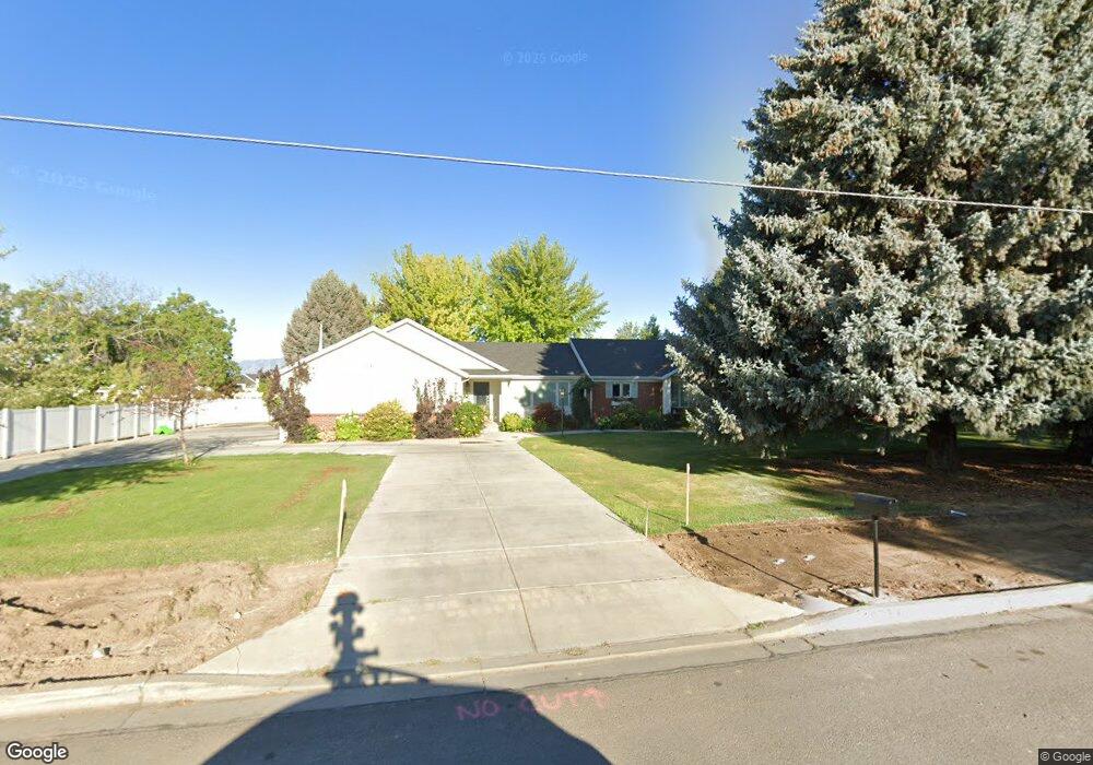
10739 N 6000 W Highland, UT 84003
Estimated Value: $1,538,000 - $1,646,000
5
Beds
6
Baths
3,439
Sq Ft
$464/Sq Ft
Est. Value
About This Home
This home is located at 10739 N 6000 W, Highland, UT 84003 and is currently estimated at $1,597,307, approximately $464 per square foot. 10739 N 6000 W is a home located in Utah County with nearby schools including Highland Elementary School, Mountain Ridge Junior High School, and Lone Peak High School.
Ownership History
Date
Name
Owned For
Owner Type
Purchase Details
Closed on
Oct 30, 2024
Sold by
Karen K Moore 1991 Living Trust and Moore Karen K
Bought by
Kimball David V and Kimball Marianne
Current Estimated Value
Home Financials for this Owner
Home Financials are based on the most recent Mortgage that was taken out on this home.
Original Mortgage
$567,000
Outstanding Balance
$561,324
Interest Rate
6.09%
Mortgage Type
New Conventional
Estimated Equity
$1,035,983
Purchase Details
Closed on
Nov 13, 2017
Sold by
Moore Karen K
Bought by
Moore Karen K and Stace Moore James Herbert
Create a Home Valuation Report for This Property
The Home Valuation Report is an in-depth analysis detailing your home's value as well as a comparison with similar homes in the area
Home Values in the Area
Average Home Value in this Area
Purchase History
| Date | Buyer | Sale Price | Title Company |
|---|---|---|---|
| Kimball David V | -- | Bartlett Title | |
| Kimball David V | -- | Bartlett Title | |
| Moore Karen K | -- | None Available | |
| Moore Karen K | -- | None Available |
Source: Public Records
Mortgage History
| Date | Status | Borrower | Loan Amount |
|---|---|---|---|
| Open | Kimball David V | $567,000 |
Source: Public Records
Tax History Compared to Growth
Tax History
| Year | Tax Paid | Tax Assessment Tax Assessment Total Assessment is a certain percentage of the fair market value that is determined by local assessors to be the total taxable value of land and additions on the property. | Land | Improvement |
|---|---|---|---|---|
| 2025 | $6,903 | $970,995 | $625,100 | $969,100 |
| 2024 | $6,903 | $852,645 | $0 | $0 |
| 2023 | $6,356 | $846,865 | $0 | $0 |
| 2022 | $6,018 | $1,258,300 | $567,200 | $691,100 |
| 2021 | $5,086 | $887,400 | $347,500 | $539,900 |
| 2020 | $4,772 | $821,200 | $302,100 | $519,100 |
| 2019 | $4,124 | $734,700 | $302,100 | $432,600 |
| 2018 | $3,233 | $527,100 | $297,100 | $230,000 |
| 2017 | $2,895 | $289,900 | $0 | $0 |
| 2016 | $2,673 | $250,175 | $0 | $0 |
| 2015 | $2,747 | $243,685 | $0 | $0 |
| 2014 | $2,681 | $242,585 | $0 | $0 |
Source: Public Records
Map
Nearby Homes
- 10818 N 6000 W
- 6271 W 10830 St N
- 11124 N 6000 W
- 6373 W 10500 N
- 6372 W 10400 N
- 10434 N 6400 W
- 11248 Hawkstone Way Unit 109
- 6024 Hawkstone Way Unit 108
- 11228 Hawkstone Way Unit 110
- 11337 N 5950 W Unit 7
- 5538 W Naples Dr Unit 125
- 5538 W Turin Ln
- 5509 W Sicily Ln
- 10925 N Marsala Dr
- 10905 N Vercelli Dr
- 10507 N 5470 W
- 10763 N Dosh Ln
- 10197 N 5750 W
- Villa A Plan at TEN700
- Villa D Plan at TEN700
- 10800 N 6000 W
- 10781 N 6000 W
- 5984 W Woodshire Ln Unit 1
- 5984 W Woodshire Ln
- 10754 N 6000 W
- 10801 N 6000 W
- 5987 W Woodshire Ln
- 8330 W 10800 St N
- 7679 W 10800 St N
- 8418 W 10800 St N
- 8464 W 10800 St N
- 10695 N 6000 W
- 5975 W 10800 N
- 5971 W Woodshire Ln Unit 25
- 5976 W Woodshire Ln Unit 2
- 5976 W Woodshire Ln
- 5984 W 10800 N
- 10592 N 6000 W Unit 1
- 9645 N 6000 W Unit 1
- 5961 W 10800 St N