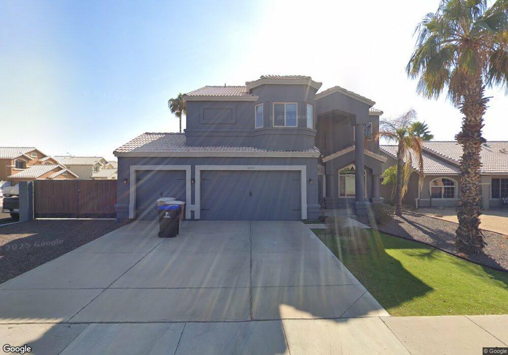
10739 W Melinda Ln Sun City, AZ 85373
Estimated Value: $495,820 - $532,000
4
Beds
4
Baths
1,993
Sq Ft
$261/Sq Ft
Est. Value
About This Home
This home is located at 10739 W Melinda Ln, Sun City, AZ 85373 and is currently estimated at $519,205, approximately $260 per square foot. 10739 W Melinda Ln is a home located in Maricopa County with nearby schools including Parkridge Elementary School, Sunrise Mountain High School, and Candeo Peoria.
Ownership History
Date
Name
Owned For
Owner Type
Purchase Details
Closed on
Jul 20, 2022
Sold by
Davis and Shawna
Bought by
Kernan John E and Kernan Trisha N
Current Estimated Value
Home Financials for this Owner
Home Financials are based on the most recent Mortgage that was taken out on this home.
Original Mortgage
$569,696
Outstanding Balance
$545,099
Interest Rate
5.78%
Mortgage Type
VA
Estimated Equity
-$25,894
Purchase Details
Closed on
Apr 25, 2008
Sold by
Federal Home Loan Mortgage Corporation
Bought by
Davis Dustin and Davis Shawna
Home Financials for this Owner
Home Financials are based on the most recent Mortgage that was taken out on this home.
Original Mortgage
$213,831
Interest Rate
5.88%
Mortgage Type
VA
Purchase Details
Closed on
Mar 31, 2008
Sold by
Suntrust Mortgage Inc
Bought by
Federal Home Loan Mortgage Assn
Home Financials for this Owner
Home Financials are based on the most recent Mortgage that was taken out on this home.
Original Mortgage
$213,831
Interest Rate
5.88%
Mortgage Type
VA
Purchase Details
Closed on
Mar 18, 2008
Sold by
Elia Todd and Elia Loretta M
Bought by
Suntrust Mortgage Inc
Home Financials for this Owner
Home Financials are based on the most recent Mortgage that was taken out on this home.
Original Mortgage
$213,831
Interest Rate
5.88%
Mortgage Type
VA
Purchase Details
Closed on
Oct 26, 2004
Sold by
Oconnor Tim and Oconnor Coleen P
Bought by
Elia Todd and Elia Loretta M
Home Financials for this Owner
Home Financials are based on the most recent Mortgage that was taken out on this home.
Original Mortgage
$224,200
Interest Rate
5.74%
Mortgage Type
New Conventional
Purchase Details
Closed on
Jun 5, 2003
Sold by
Oconnor Coleen P
Bought by
Oconnor Tim and Oconnoe Coleen P
Home Financials for this Owner
Home Financials are based on the most recent Mortgage that was taken out on this home.
Original Mortgage
$20,500
Interest Rate
5.17%
Mortgage Type
Credit Line Revolving
Purchase Details
Closed on
Nov 15, 2001
Sold by
Oconnor Timothy P
Bought by
Oconnor Coleen P
Purchase Details
Closed on
Sep 30, 1997
Sold by
Luxury Plus Development Ltd
Bought by
Oconnor Timothy P and Oconnor Coleen P
Home Financials for this Owner
Home Financials are based on the most recent Mortgage that was taken out on this home.
Original Mortgage
$120,400
Interest Rate
7.44%
Mortgage Type
New Conventional
Create a Home Valuation Report for This Property
The Home Valuation Report is an in-depth analysis detailing your home's value as well as a comparison with similar homes in the area
Home Values in the Area
Average Home Value in this Area
Purchase History
| Date | Buyer | Sale Price | Title Company |
|---|---|---|---|
| Kernan John E | $549,900 | New Title Company Name | |
| Davis Dustin | $207,000 | Chicago Title | |
| Federal Home Loan Mortgage Assn | -- | First American Title | |
| Suntrust Mortgage Inc | $304,424 | None Available | |
| Elia Todd | $236,000 | Security Title Agency Inc | |
| Oconnor Tim | -- | Fidelity National Title | |
| Oconnor Coleen P | -- | -- | |
| Oconnor Timothy P | $126,758 | Stewart Title & Trust |
Source: Public Records
Mortgage History
| Date | Status | Borrower | Loan Amount |
|---|---|---|---|
| Open | Kernan John E | $569,696 | |
| Previous Owner | Davis Dustin | $213,831 | |
| Previous Owner | Elia Todd | $224,200 | |
| Previous Owner | Oconnor Tim | $20,500 | |
| Previous Owner | Oconnor Timothy P | $120,400 |
Source: Public Records
Tax History Compared to Growth
Tax History
| Year | Tax Paid | Tax Assessment Tax Assessment Total Assessment is a certain percentage of the fair market value that is determined by local assessors to be the total taxable value of land and additions on the property. | Land | Improvement |
|---|---|---|---|---|
| 2025 | $1,616 | $20,469 | -- | -- |
| 2024 | $1,589 | $19,495 | -- | -- |
| 2023 | $1,589 | $33,820 | $6,760 | $27,060 |
| 2022 | $1,556 | $26,010 | $5,200 | $20,810 |
| 2021 | $1,664 | $24,270 | $4,850 | $19,420 |
| 2020 | $1,680 | $22,650 | $4,530 | $18,120 |
| 2019 | $1,627 | $20,610 | $4,120 | $16,490 |
| 2018 | $1,566 | $19,100 | $3,820 | $15,280 |
| 2017 | $1,567 | $17,680 | $3,530 | $14,150 |
| 2016 | $1,551 | $16,570 | $3,310 | $13,260 |
| 2015 | $1,447 | $15,100 | $3,020 | $12,080 |
Source: Public Records
Map
Nearby Homes
- 10806 W Adam Ave
- 10816 W Quail Ave
- 10549 W Albert Ln
- 10816 W Deanna Dr
- 10824 W Sands Dr
- 10446 W Lone Cactus Dr
- 10672 W Ross Ave
- 20957 N 107th Dr
- 21479 N 104th Dr
- 20769 N 106th Ln
- 10528 W Potter Dr
- 10456 W Los Gatos Dr
- 10728 W Irma Ln
- 10722 W Irma Ln
- 10368 W Ross Ave
- 20670 N 105th Dr
- 21635 N 102nd Ave
- 10370 W Sands Dr Unit 463
- 10630 W Mohawk Ln
- 20615 N 105th Ave
- 10743 W Melinda Ln
- 10744 W Salter Dr Unit SHARP
- 10744 W Salter Dr
- 10752 W Salter Dr
- 10759 W Melinda Ln
- 21535 N 107th Dr
- 21620 N 107th Dr
- 21545 N 107th Dr
- 21525 N 107th Dr
- 10760 W Salter Dr
- 21615 N 107th Dr
- 21515 N 107th Dr
- 21615 N 108th Ave
- 21630 N 107th Dr
- 10767 W Melinda Ln
- 10768 W Salter Dr
- 21625 N 107th Dr
- 21465 N 107th Dr
- 21625 N 108th Ave
- 10743 W Salter Dr