NOT LISTED FOR SALE

10743 Wooton Rd West Fork, AR 72774

Estimated Value: $158,685 - $659,000

24 Acres
$14,922 Price per Acre
1,026,274 Sq Ft Lot

Last Sold November 13, 2019

Last sale price $94,240 $63 Per Sq Ft

Est. 273% increase in value since last sale

Current estimated payment $1,982/month

33 Days on Market

Highlights

  • Home fronts a pond
  • Partially Wooded Lot
  • Creek or Stream
  • Pond
  • Views
  • Partially Fenced Property

About This Lot

As of November 2019

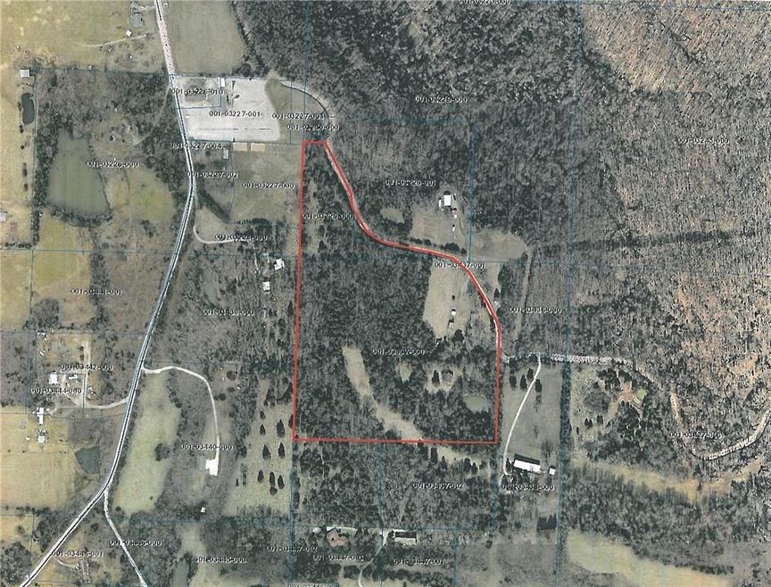
An existing water tap and electric meter are on the premises of this exceptional 30 Acres with over ¼ mile of County Road frontage all located only a 2.25 miles drive to I49 Exit #53 at West Fork. The high point elevation of 1875 ft. offers exceptional views! 2 beautiful ponds, and approximately 1/3 or more of the land is pasture so raising your favorite farm animals here is a reality. A barn is on the property and a historical dug water well. Land is priced at $4500/Acre and a survey will determine the exact acreage amount. Take advantage of the existing utilities and build your well located dream home only 15 minutes from the University of Arkansas.

Last Agent to Sell the Property

Jan Newlin

Newlin Realty Company License #PB00008437 Listed on: 09/10/2019

Last Buyer's Agent

Diane Schultz

Prime Real Estate and Development License #SA00059507

Property Details

Property Type

  • Land

Est. Annual Taxes

  • $745

Lot Details

  • 23.56 Acre Lot
  • Home fronts a pond
  • Property fronts a county road
  • Creek or Stream
  • Rural Setting
  • Partially Fenced Property
  • Level Lot
  • Open Lot
  • Partially Wooded Lot
  • Zoning described as Agricultural

Home Design

  • Mixed Use

Additional Features

  • Pond
  • Outside City Limits
  • Mobile Home Allowed
  • Natural Gas Not Available
  • Property Views

Property Details

Property Type

Land

Est. Annual Taxes

$745

Lot Details

0

Listing Details

  • Property Sub Type: Mixed Use
  • Prop. Type: Land
  • Lot Size Acres: 23.56
  • Road Frontage Type: County Road
  • Road Surface Type: Gravel
  • Subdivision Name: .
  • Directions: I-49 exit# 53 and right on Hwy 170 1.7 miles then left on county road 225 for approx. 1/4 mile to land on right.
  • ResoPropertyType: Land
  • Property Sub Type Additional: Mixed Use
  • Special Features: None

Interior Features

  • Possible Use: Agricultural, Pasture, Residential

Exterior Features

  • Fencing: Partial
  • Lot Features: Mobile Home Allowed, Not In Subdivision, Outside City Limits, Open Lot, Other, Rolling Slope, Rural Lot, Sloped, See Remarks, Level, Pond, Stream/Creek, Wooded
  • Topography: Cleared,Level
  • View: Yes
  • Waterfront Features: Pond

Utilities

  • Electricity On Property: Yes
  • Utilities: Natural Gas Not Available, Electricity Available
  • Water Source: Public

Schools

  • Junior High Dist: West Fork

Lot Info

  • Additional Parcels Description: 001-03229-000
  • Zoning Description: Agricultural
  • Zoning: N
  • ResoLotSizeUnits: Acres

Tax Info

  • Tax Annual Amount: 745.0
  • Tax Block: .
  • Tax Lot: .

Range of Values:

Collateral Analytics

Collateral Analytics Collateral Analytics AVMs (Automated Valuation Model) employ a number of statistical approaches combined with neighborhood-specific comparable selection guarantees the most up-to-date and precise valuations.

Not Available

Collateral Analytics does not have data for the current month. Please view the chart for historical values.

ICE

ICE Mortgage Technology ICE Mortgage Technology’s AVM (Automated Valuation Model) is a state-of-the-art online residential property valuation tool that provides a quick and accurate estimate of the value of almost any home in the U.S.

Not Available

ICE Mortgage Technology does not have data for the current month. Please view the chart for historical values.

First American

First American First American Data & Analytics’ next-generation AVM combines unrivaled data assets with a blended ensemble of valuation models to produce highly accurate, reliable valuations you can trust.

Not Available

First American does not have data for the current month. Please view the chart for historical values.

Quantarium

Quantarium Quantarium’s valuation service, repeatedly proven the industry’s most accurate and comprehensive, is supercharged with a self-learning and auto-tuning AI engine that continually becomes smarter and more accurate as it processes daily inputs from the industry’s leading RE data lake.

Not Available

Quantarium does not have data for the current month. Please view the chart for historical values.

Average Value
Not Available
List Price
Sold Price
Create a Home Valuation Report for This Property
The Home Valuation Report is an in-depth analysis detailing your home's value as well as a comparison with similar homes in the area

Home Values in the Area

Source: Public Records

Average Home Value in this Area


Source: Public Records

Property History

Date Event Price Change Sq Ft Price
11/13/2019 11/13/19 Sold $94,240 -30.2% $63 / Sq Ft
10/14/2019 10/14/19 Pending -- -- --
09/10/2019 09/10/19 For Sale $135,000 -- $91 / Sq Ft
Source: Northwest Arkansas Board of REALTORS®

Tax History Compared to Growth

Source: Public Records

Tax History

Year Tax Paid Tax Assessment Tax Assessment Total Assessment is a certain percentage of the fair market value that is determined by local assessors to be the total taxable value of land and additions on the property. Land Improvement
2024 $480 $12,540 $4,880 $7,660
2023 $442 $12,540 $4,880 $7,660
2022 $402 $8,350 $2,790 $5,560
2021 $402 $8,350 $2,790 $5,560
2020 $402 $8,350 $2,790 $5,560
Source: Public Records

Agents Affiliated with this Home

  • Section Image
  • Section Image
See All Agents

Map

Source: Northwest Arkansas Board of REALTORS®

MLS Number: 1126396

Northwest Arkansas Board of REALTORS®

APN: 001-03437-005