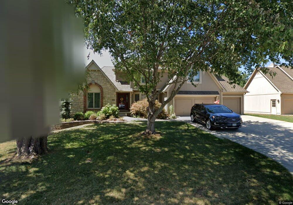
1075 NW High Point Dr Lees Summit, MO 64081
Estimated Value: $475,000 - $525,000
4
Beds
4
Baths
2,625
Sq Ft
$191/Sq Ft
Est. Value
About This Home
This home is located at 1075 NW High Point Dr, Lees Summit, MO 64081 and is currently estimated at $500,130, approximately $190 per square foot. 1075 NW High Point Dr is a home located in Jackson County with nearby schools including Cedar Creek Elementary School, Bernard C. Campbell Middle School, and Lee's Summit North High School.
Ownership History
Date
Name
Owned For
Owner Type
Purchase Details
Closed on
Jun 29, 2005
Sold by
Morrow William A and Morrow Brenda
Bought by
Morrow William A and Morrow Brenda E
Current Estimated Value
Purchase Details
Closed on
Jul 23, 1997
Sold by
Browne Robert T and Browne Sherry L
Bought by
Morrow William A and Morrow Brenda
Home Financials for this Owner
Home Financials are based on the most recent Mortgage that was taken out on this home.
Original Mortgage
$178,000
Outstanding Balance
$23,540
Interest Rate
6.62%
Mortgage Type
Purchase Money Mortgage
Estimated Equity
$476,591
Create a Home Valuation Report for This Property
The Home Valuation Report is an in-depth analysis detailing your home's value as well as a comparison with similar homes in the area
Home Values in the Area
Average Home Value in this Area
Purchase History
| Date | Buyer | Sale Price | Title Company |
|---|---|---|---|
| Morrow William A | -- | -- | |
| Morrow William A | -- | Security Land Title Company |
Source: Public Records
Mortgage History
| Date | Status | Borrower | Loan Amount |
|---|---|---|---|
| Open | Morrow William A | $178,000 |
Source: Public Records
Tax History
| Year | Tax Paid | Tax Assessment Tax Assessment Total Assessment is a certain percentage of the fair market value that is determined by local assessors to be the total taxable value of land and additions on the property. | Land | Improvement |
|---|---|---|---|---|
| 2025 | $4,871 | $77,575 | $12,724 | $64,851 |
| 2024 | $4,836 | $67,458 | $6,270 | $61,188 |
| 2023 | $4,836 | $67,458 | $6,270 | $61,188 |
| 2022 | $4,755 | $58,900 | $8,341 | $50,559 |
| 2021 | $4,853 | $58,900 | $8,341 | $50,559 |
| 2020 | $4,901 | $58,900 | $8,341 | $50,559 |
| 2019 | $4,767 | $58,900 | $8,341 | $50,559 |
| 2018 | $4,776 | $54,761 | $6,370 | $48,391 |
| 2017 | $4,776 | $54,761 | $6,370 | $48,391 |
| 2016 | $4,677 | $53,086 | $8,189 | $44,897 |
Source: Public Records
Map
Nearby Homes
- 955 NW High Point Dr
- 13004 E 99th St
- 130 NW Ambersham Dr
- 2635 NW Ashurst Ln
- 334 NW Ambersham Dr
- 2122 NW Ashurst Dr
- 14301 E 97 Terrace
- 2110 NW Ashurst Dr
- 321 NW Nutall Dr
- 433 NW Kaylea Ct
- 10401 View High Dr
- 2090 NW O'Brien Rd
- 2086 NW O'Brien Rd
- 2809 NW Audubon Ln
- 2070 NW O'Brien Rd
- 2214 NW Killarney Ln
- 209 NW Cody Dr
- 317 NW Lovins
- 316 NW Lovins
- 320 NW Lovins
- 1079 NW High Point Dr
- 1071 NW High Point Dr
- 935 NW High Point Dr
- 1067 NW High Point Dr
- 1072 NW High Point Dr
- 1076 NW High Point Dr
- 1083 NW High Point Dr
- 1080 NW High Point Dr
- 1068 NW High Point Dr
- 939 NW High Point Dr
- 1084 NW High Point Dr
- 1063 NW High Point Dr
- 943 NW High Point Dr
- 1088 NW High Point Dr
- 1008 NW Silverthorn Dr
- 1064 NW High Point Dr
- 936 NW High Point Dr
- 1051 NW High Point Dr
- 932 NW High Point Dr
- 928 NW High Point Dr
Your Personal Tour Guide
Ask me questions while you tour the home.