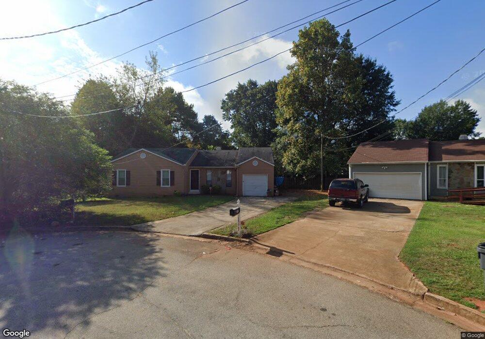
1077 Reynolds Ct Morrow, GA 30260
Estimated Value: $222,516 - $239,000
3
Beds
2
Baths
1,486
Sq Ft
$156/Sq Ft
Est. Value
About This Home
This home is located at 1077 Reynolds Ct, Morrow, GA 30260 and is currently estimated at $232,129, approximately $156 per square foot. 1077 Reynolds Ct is a home located in Clayton County with nearby schools including Lake City Elementary School, Babb Middle School, and Forest Park High School.
Ownership History
Date
Name
Owned For
Owner Type
Purchase Details
Closed on
Apr 23, 2025
Sold by
Rh Partners Warehouse Ownerco Llc
Bought by
Rh Partners Ownerco 2 Llc
Current Estimated Value
Purchase Details
Closed on
Jul 29, 2024
Sold by
Rh Partners Ownerco Llc
Bought by
Rh Partners Warehouse Ownerco Llc
Purchase Details
Closed on
May 11, 2017
Sold by
Mackinnon Robin J
Bought by
Trans Am Sfe Ii Llc
Purchase Details
Closed on
Jun 3, 2008
Sold by
Battle Malcolm
Bought by
Mackinnon Robin J
Purchase Details
Closed on
Aug 1, 2006
Sold by
Washington Mutual Bk Fa
Bought by
Hud
Purchase Details
Closed on
Mar 29, 1993
Sold by
Butt Paulette
Bought by
Slaton Tony Robin
Home Financials for this Owner
Home Financials are based on the most recent Mortgage that was taken out on this home.
Original Mortgage
$60,567
Interest Rate
9.5%
Mortgage Type
FHA
Create a Home Valuation Report for This Property
The Home Valuation Report is an in-depth analysis detailing your home's value as well as a comparison with similar homes in the area
Home Values in the Area
Average Home Value in this Area
Purchase History
| Date | Buyer | Sale Price | Title Company |
|---|---|---|---|
| Rh Partners Ownerco 2 Llc | $1,076,880 | -- | |
| Rh Partners Ownerco 2 Llc | $1,076,880 | -- | |
| Rh Partners Warehouse Ownerco Llc | $396,338 | -- | |
| Rh Partners Ownerco Llc | -- | -- | |
| Rh Partners Warehouse Ownerco Llc | $396,338 | -- | |
| Rh Partners Ownerco Llc | -- | -- | |
| Trans Am Sfe Ii Llc | $90,000 | -- | |
| Trans Am Sfe Ii Llc | $90,000 | -- | |
| Mackinnon Robin J | $75,000 | -- | |
| Mackinnon Robin J | $75,000 | -- | |
| Hud | -- | -- | |
| Washington Mutual Bk Fa | $100,997 | -- | |
| Hud | -- | -- | |
| Washington Mutual Bk Fa | $100,997 | -- | |
| Slaton Tony Robin | $9,000 | -- | |
| Slaton Tony Robin | $9,000 | -- |
Source: Public Records
Mortgage History
| Date | Status | Borrower | Loan Amount |
|---|---|---|---|
| Previous Owner | Slaton Tony Robin | $60,567 | |
| Closed | Slaton Tony Robin | $2,500 |
Source: Public Records
Tax History Compared to Growth
Tax History
| Year | Tax Paid | Tax Assessment Tax Assessment Total Assessment is a certain percentage of the fair market value that is determined by local assessors to be the total taxable value of land and additions on the property. | Land | Improvement |
|---|---|---|---|---|
| 2025 | $4,018 | $104,000 | $7,200 | $96,800 |
| 2024 | $3,421 | $86,800 | $7,200 | $79,600 |
| 2023 | $3,134 | $86,800 | $7,200 | $79,600 |
| 2022 | $2,280 | $57,200 | $6,864 | $50,336 |
| 2021 | $2,294 | $57,200 | $6,864 | $50,336 |
| 2020 | $2,036 | $58,856 | $7,200 | $51,656 |
| 2019 | $2,089 | $50,586 | $4,800 | $45,786 |
| 2018 | $1,703 | $41,078 | $4,800 | $36,278 |
| 2017 | $1,019 | $24,193 | $4,800 | $19,393 |
| 2016 | $1,013 | $24,036 | $4,800 | $19,236 |
| 2015 | $704 | $0 | $0 | $0 |
| 2014 | $528 | $12,400 | $5,600 | $6,800 |
Source: Public Records
Map
Nearby Homes
- 1112 Reynolds Ct Unit 4
- 5489 Ahyoka Dr
- 1063 Pine Mountain Dr
- 965 Cone Rd
- 5690 Cypress Dr
- 5570 Ash St
- 1124 Ponderosa Park Dr
- 1167 Sanders Dr
- 865 Oakdale Dr
- 0 Ash St Unit 10563129
- 960 Longleaf Dr
- 1343 Burbank Trail
- 913 Longleaf Dr
- 743 Brookwood Dr
- 5344 Sharon St
- 843 White Oak Dr
- 927 Slash Pine Rd
- 5355 Sharon St
- 893 Slash Pine Rd
- 6057 Pinecreek Rd
- 1077 Reynolds Ct Unit 39
- 1077 Reynolds Ct
- 1081 Reynolds Ct
- 1104 Pine Meadows Dr Unit 3
- 1078 Reynolds Ct
- 1112 Pine Meadows Dr Unit III
- 1096 Pine Meadows Dr
- 1089 Reynolds Ct Unit IV
- 1126 Pine Meadows Dr
- 1082 Reynolds Ct
- 1130 Pine Meadows Dr
- 1088 Pine Meadows Dr
- 1086 Reynolds Ct
- 1119 Reynolds Ct
- 1103 Reynolds Ct
- 1134 Pine Meadows Dr
- 1080 Pine Meadows Dr
- 1127 Reynolds Ct
- 1090 Reynolds Ct
- 1111 Pine Meadows Dr