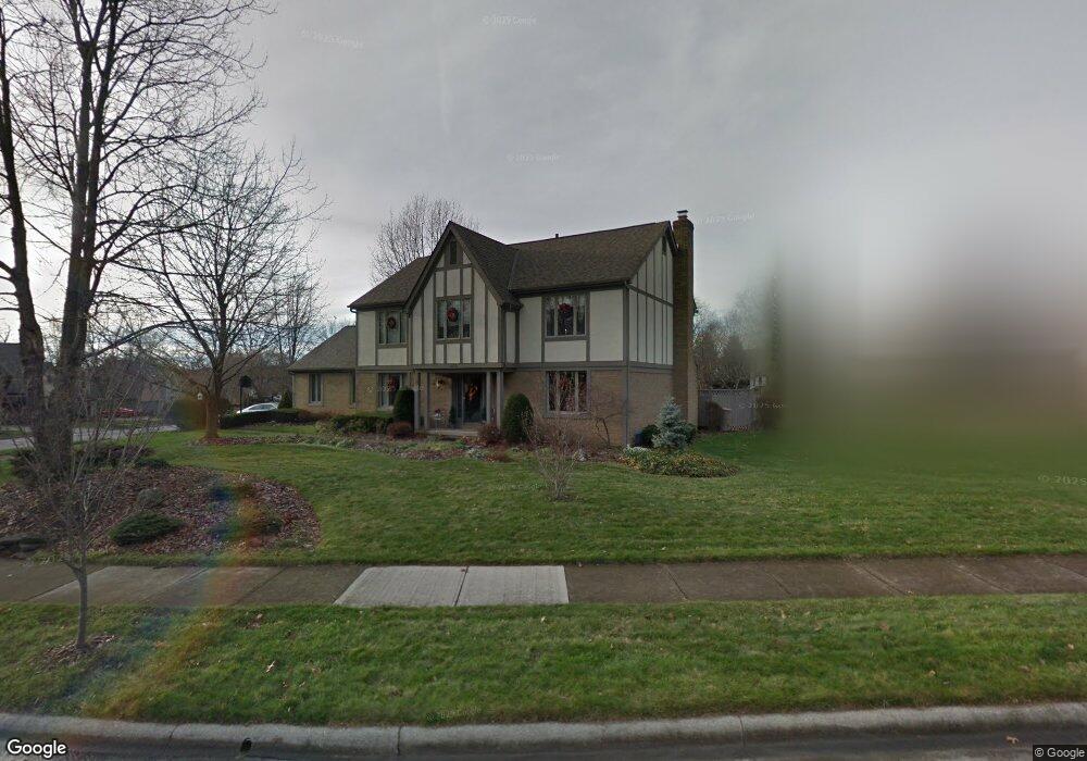
1079 Denman Ct Westerville, OH 43081
Estimated Value: $487,843 - $550,000
4
Beds
3
Baths
2,440
Sq Ft
$213/Sq Ft
Est. Value
About This Home
This home is located at 1079 Denman Ct, Westerville, OH 43081 and is currently estimated at $519,961, approximately $213 per square foot. 1079 Denman Ct is a home located in Franklin County with nearby schools including Mcvay Elementary School, Walnut Springs Middle School, and Westerville-North High School.
Ownership History
Date
Name
Owned For
Owner Type
Purchase Details
Closed on
Jun 13, 1994
Sold by
Byrnes R J
Bought by
Sims Randy R and Sims Carolyn M
Current Estimated Value
Home Financials for this Owner
Home Financials are based on the most recent Mortgage that was taken out on this home.
Original Mortgage
$117,000
Interest Rate
8.45%
Mortgage Type
New Conventional
Purchase Details
Closed on
May 28, 1987
Create a Home Valuation Report for This Property
The Home Valuation Report is an in-depth analysis detailing your home's value as well as a comparison with similar homes in the area
Home Values in the Area
Average Home Value in this Area
Purchase History
| Date | Buyer | Sale Price | Title Company |
|---|---|---|---|
| Sims Randy R | $202,500 | -- | |
| -- | $175,200 | -- |
Source: Public Records
Mortgage History
| Date | Status | Borrower | Loan Amount |
|---|---|---|---|
| Closed | Sims Randy R | $117,000 |
Source: Public Records
Tax History Compared to Growth
Tax History
| Year | Tax Paid | Tax Assessment Tax Assessment Total Assessment is a certain percentage of the fair market value that is determined by local assessors to be the total taxable value of land and additions on the property. | Land | Improvement |
|---|---|---|---|---|
| 2024 | $7,820 | $137,590 | $43,750 | $93,840 |
| 2023 | $7,654 | $137,585 | $43,750 | $93,835 |
| 2022 | $8,219 | $112,810 | $21,000 | $91,810 |
| 2021 | $8,288 | $112,810 | $21,000 | $91,810 |
| 2020 | $8,264 | $112,810 | $21,000 | $91,810 |
| 2019 | $7,271 | $93,700 | $17,500 | $76,200 |
| 2018 | $6,965 | $93,700 | $17,500 | $76,200 |
| 2017 | $7,151 | $93,700 | $17,500 | $76,200 |
| 2016 | $7,022 | $83,760 | $22,580 | $61,180 |
| 2015 | $6,801 | $83,760 | $22,580 | $61,180 |
| 2014 | $6,806 | $83,760 | $22,580 | $61,180 |
| 2013 | $3,237 | $79,765 | $21,490 | $58,275 |
Source: Public Records
Map
Nearby Homes
- 969 Farrington Dr
- 1368 Nutmeg Ct
- 613 Valley Wood Ct
- 1003 Autumn Meadows Dr
- 858 Knebworth Ct
- 857 E Walnut St
- 1015 Autumn Woods Dr
- 994 Autumn Lake Ct
- 1203 Autumn Creek Cir
- 539 Cherrington Rd
- 283 Apache Cir
- 192 Buckeye Ct
- 187 Bernadine Ct
- 615 Vancouver Dr
- 768 Collingwood Dr
- 430 Electric Ave
- 437 Potawatomi Dr
- 393 Sentry Ln
- 974 Timberbank Dr
- 203 Fairdale Ave
- 1054 Denman Ct
- 1087 Denman Ct
- 1075 Farrington Dr
- 1046 Denman Ct
- 1084 Denman Ct
- 1078 Denman Ct
- 1067 Farrington Dr
- 1099 Farrington Dr
- 1065 Denman Ct
- 1071 Denman Ct
- 1059 Denman Ct
- 1038 Denman Ct
- 1051 Denman Ct
- 1059 Farrington Dr
- 1086 Farrington Dr
- 1078 Farrington Dr
- 1094 Farrington Dr
- 1113 Farrington Dr
- 1043 Denman Ct
- 1070 Farrington Dr