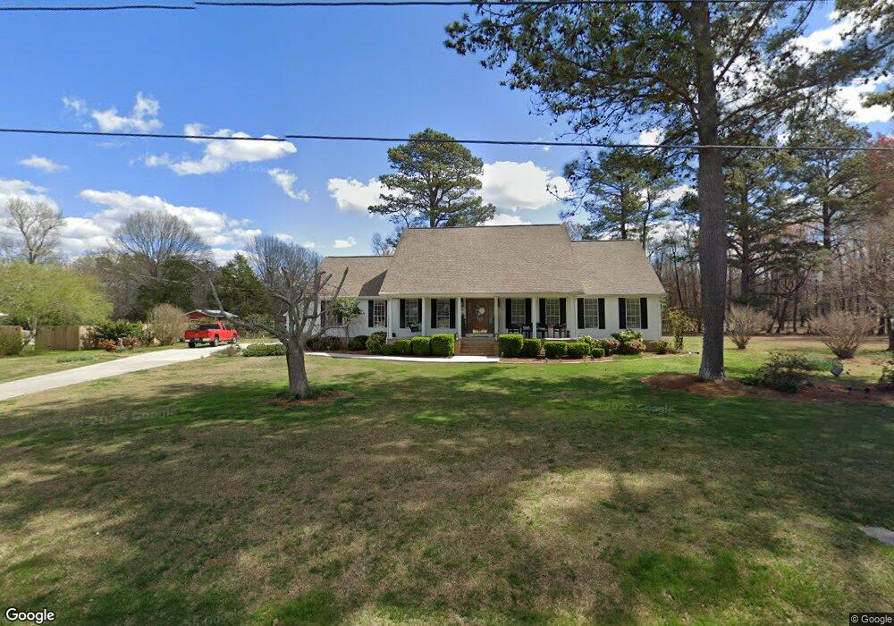
108 Graham Cir Rock Spring, GA 30739
Rock Spring NeighborhoodEstimated Value: $245,331 - $289,000
--
Bed
2
Baths
1,605
Sq Ft
$166/Sq Ft
Est. Value
About This Home
This home is located at 108 Graham Cir, Rock Spring, GA 30739 and is currently estimated at $266,333, approximately $165 per square foot. 108 Graham Cir is a home located in Walker County with nearby schools including Rock Spring Elementary School, Lafayette High School, and Alice M Daley Adventist School.
Ownership History
Date
Name
Owned For
Owner Type
Purchase Details
Closed on
Nov 1, 1992
Sold by
Deck Sanford and Deck Sue M
Bought by
Brown Tom and Brown Debbie
Current Estimated Value
Purchase Details
Closed on
Jul 8, 1988
Sold by
Fred Fred C and Fred Betty M
Bought by
Deck Sanford and Deck Sue M
Purchase Details
Closed on
May 31, 1985
Sold by
Deck Sanford
Bought by
Fred Fred C and Fred Betty M
Purchase Details
Closed on
Jan 1, 1964
Bought by
Deck Sanford
Create a Home Valuation Report for This Property
The Home Valuation Report is an in-depth analysis detailing your home's value as well as a comparison with similar homes in the area
Home Values in the Area
Average Home Value in this Area
Purchase History
| Date | Buyer | Sale Price | Title Company |
|---|---|---|---|
| Brown Tom | $7,500 | -- | |
| Deck Sanford | -- | -- | |
| Fred Fred C | $7,500 | -- | |
| Deck Sanford | -- | -- |
Source: Public Records
Tax History Compared to Growth
Tax History
| Year | Tax Paid | Tax Assessment Tax Assessment Total Assessment is a certain percentage of the fair market value that is determined by local assessors to be the total taxable value of land and additions on the property. | Land | Improvement |
|---|---|---|---|---|
| 2024 | $769 | $96,089 | $12,620 | $83,469 |
| 2023 | $708 | $91,956 | $12,620 | $79,336 |
| 2022 | $519 | $81,540 | $12,620 | $68,920 |
| 2021 | $318 | $68,672 | $12,620 | $56,052 |
| 2020 | $168 | $57,792 | $12,620 | $45,172 |
| 2019 | $167 | $57,792 | $12,620 | $45,172 |
| 2018 | $1,529 | $57,792 | $12,620 | $45,172 |
| 2017 | $1,838 | $57,792 | $12,620 | $45,172 |
| 2016 | $1,495 | $57,792 | $12,620 | $45,172 |
| 2015 | $1,455 | $52,889 | $13,884 | $39,005 |
| 2014 | $1,349 | $52,889 | $13,884 | $39,005 |
| 2013 | -- | $52,889 | $13,884 | $39,005 |
Source: Public Records
Map
Nearby Homes
- 10180 Us Highway 27
- 1003 Highway N Old 27
- 5602 Georgia 95
- 00 Georgia 95
- 1370 Old Highway 27
- 15 Willow Cir
- 23 Willow Cir
- 701 Bicentennial Trail
- 16 Willow Cir
- 11 Willow Cir
- The Pearson Plan at Laurel Ridge
- The Benson II Plan at Laurel Ridge
- The Langford Plan at Laurel Ridge
- The Lawson Plan at Laurel Ridge
- The Piedmont Plan at Laurel Ridge
- The Coleman Plan at Laurel Ridge
- The McGinnis Plan at Laurel Ridge
- The Caldwell Plan at Laurel Ridge
- 118 Graham Cir
- 115 Graham Cir
- 138 Graham Cir
- 50 Graham Cir
- 45 Graham Cir
- 148 Graham Cir
- 191 Graham Cir
- 267 Graham Cir
- 14 Graham Cir
- 132 Graham Rd
- 289 Graham Cir
- 0 Graham Cir Unit 1084962
- 0 Graham Cir Unit 1001143
- 0 Graham Cir Unit 8050035
- 309 Graham Cir
- 178 Graham Cir
- 309 Graham Cir
- 105 Graham Rd
- 699 Graham Cir
- 194 Graham Rd