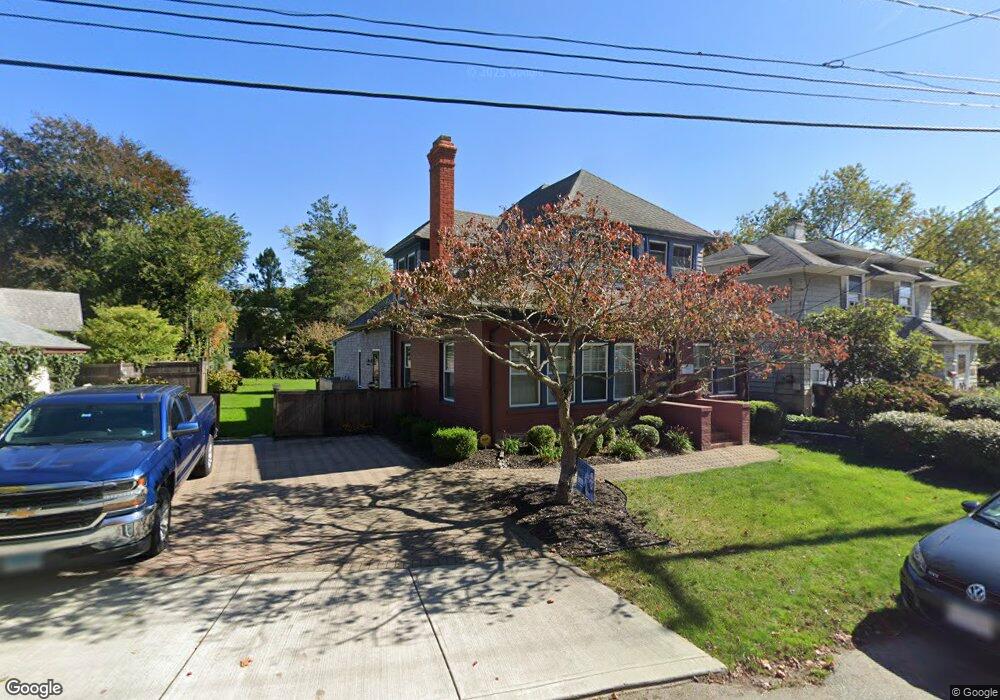
108 Lower Blvd New London, CT 06320
South New London NeighborhoodEstimated Value: $537,924 - $600,000
3
Beds
2
Baths
2,771
Sq Ft
$203/Sq Ft
Est. Value
About This Home
This home is located at 108 Lower Blvd, New London, CT 06320 and is currently estimated at $561,481, approximately $202 per square foot. 108 Lower Blvd is a home located in New London County with nearby schools including Harbor Elementary School, Bennie Dover Jackson Middle School, and New London High School.
Ownership History
Date
Name
Owned For
Owner Type
Purchase Details
Closed on
Dec 20, 2021
Sold by
Rogovin Aaron L and Rogovin Carol E
Bought by
Rogovin Aaron L and Rogovin Carol E
Current Estimated Value
Purchase Details
Closed on
Jan 12, 2015
Sold by
Rogovin Aaron
Bought by
Rogovin Aaron L and Rogovin Carol E
Create a Home Valuation Report for This Property
The Home Valuation Report is an in-depth analysis detailing your home's value as well as a comparison with similar homes in the area
Home Values in the Area
Average Home Value in this Area
Purchase History
| Date | Buyer | Sale Price | Title Company |
|---|---|---|---|
| Rogovin Aaron L | -- | None Available | |
| Rogovin Aaron L | -- | None Available | |
| Rogovin Aaron L | -- | -- | |
| Rogovin Aaron L | -- | -- |
Source: Public Records
Mortgage History
| Date | Status | Borrower | Loan Amount |
|---|---|---|---|
| Previous Owner | Rogovin Aaron L | $146,000 | |
| Previous Owner | Rogovin Aaron L | $100,000 | |
| Previous Owner | Rogovin Aaron L | $177,291 |
Source: Public Records
Tax History Compared to Growth
Tax History
| Year | Tax Paid | Tax Assessment Tax Assessment Total Assessment is a certain percentage of the fair market value that is determined by local assessors to be the total taxable value of land and additions on the property. | Land | Improvement |
|---|---|---|---|---|
| 2025 | $7,912 | $290,900 | $97,000 | $193,900 |
| 2024 | $7,923 | $288,100 | $97,000 | $191,100 |
| 2023 | $6,642 | $178,360 | $71,890 | $106,470 |
| 2022 | $6,655 | $178,360 | $71,890 | $106,470 |
| 2021 | $6,769 | $178,360 | $71,890 | $106,470 |
| 2020 | $6,812 | $178,360 | $71,890 | $106,470 |
| 2019 | $7,117 | $178,360 | $71,890 | $106,470 |
| 2018 | $7,661 | $175,140 | $63,420 | $111,720 |
| 2017 | $7,752 | $175,140 | $63,420 | $111,720 |
| 2016 | $6,857 | $169,470 | $63,420 | $106,050 |
| 2015 | $6,692 | $169,470 | $63,420 | $106,050 |
| 2014 | $5,808 | $169,470 | $63,420 | $106,050 |
Source: Public Records
Map
Nearby Homes
- 845 Ocean Ave
- 41 Niles Hill Rd
- 113 Niles Hill Rd Unit F
- 111 Niles Hill Rd Unit B
- 107 Niles Hill Rd Unit A
- 993 Pequot Ave
- 57 Westridge Rd Unit B2
- 142 Plant St
- 165 Plant St
- 19 Dart St
- 541 Montauk Ave
- 2 Maginnis Pkwy
- 41 Stuart Ave
- 194 Thames St
- 51 Thames St
- 57 Farmington Ave
- 214 Thames St
- 4 Ridgewood Ave
- 20 Harris Rd
- 25 Menghi St
- 112 Lower Blvd
- 114 Lower Blvd
- 86 Lower Blvd
- 84 Lower Blvd
- 11 Glenwood Park N
- 15 Glenwood Park N
- 78 Lower Blvd
- 2 Boulevard Ct
- 7 Boulevard Ct
- 113 Lower Blvd
- 109 Lower Blvd
- 188 Parkway N
- 68 Lower Blvd
- 174 Parkway N
- 117 Lower Blvd
- 18 Glenwood Park S
- 95 Lower Blvd
- 93 Lower Blvd
- 83 Lower Blvd
- 121 Lower Blvd