
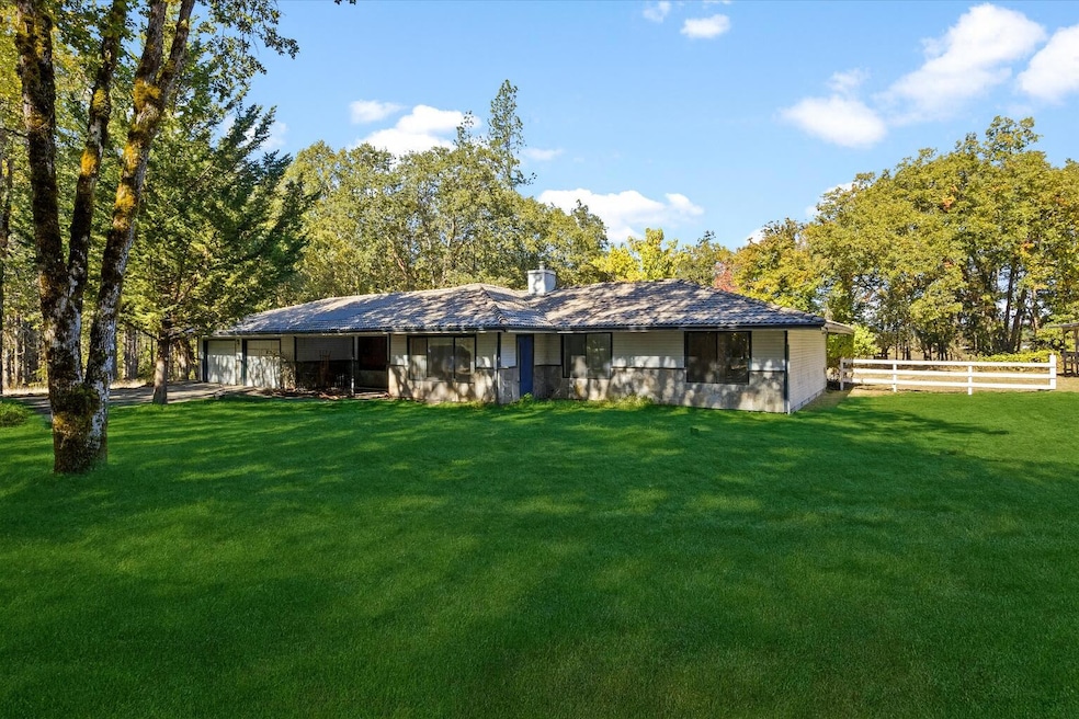
1080 Ferry Rd Grants Pass, OR 97526
Estimated payment $3,714/month
Total Views
8,467
3
Beds
2
Baths
2,290
Sq Ft
$284
Price per Sq Ft
Highlights
- Very Popular Property
- Mountain View
- Ranch Style House
- Horse Property
- Deck
- No HOA
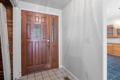
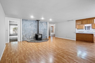
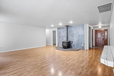
About This Home
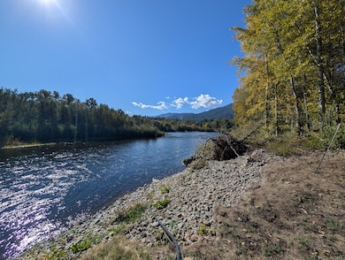
Discover peaceful living at 1080 Ferry Road, a spacious 3-bedroom, 2-bath home with 2,290 sq. ft. set on 9.44 private acres along the scenic Rogue River. This one-of-a-kind property borders BLM land, offering direct access to nature, hiking, fishing, and endless outdoor adventure right from your backyard. The home features an inviting open layout with large windows that capture tranquil forest and river views, a bright country kitchen, and a cozy living area perfect for entertaining or relaxing. Enjoy the serene sounds of the river, abundant wildlife, and the privacy of a secluded retreat just minutes from town. Out buildings include multiple animal stalls, attached garage, detached shop, and tractor shed. Water rights from the Rogue river! With flat usable land, mature trees, and proximity to the river, this property is ideal for those seeking a lifestyle that blends comfort with the beauty of Southern Oregon's outdoors.
Home Details
Home Type
- Single Family
Est. Annual Taxes
- $3,467
Year Built
- Built in 1987
Lot Details
- 9.44 Acre Lot
- Level Lot
- Front Yard Sprinklers
- Property is zoned Wr; Woodlot Resource, Wr; Woodlot Resource
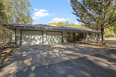
Parking
- 4 Car Garage
- Garage Door Opener
Home Design
- Ranch Style House
- Slab Foundation
- Frame Construction
- Tile Roof
Interior Spaces
- 2,290 Sq Ft Home
- Wood Burning Fireplace
- Double Pane Windows
- Aluminum Window Frames
- Family Room
- Living Room
- Dining Room
- Mountain Views
- Breakfast Area or Nook
- Laundry Room
Flooring
- Laminate
- Tile
Bedrooms and Bathrooms
- 3 Bedrooms
- 2 Full Bathrooms
Outdoor Features
- Horse Property
- Deck
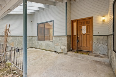
- Front Porch
Schools
- Ft Vannoy Elementary School
- Fleming Middle School
- North Valley High School
Farming
- 9 Irrigated Acres
Utilities
- Central Air
- Heat Pump System
- Irrigation Water Rights
- Well
- Septic Tank
- Fiber Optics Available
Community Details
- No Home Owners Association
- Property is near a preserve or public land
Listing and Financial Details
- Tax Lot 200
- Assessor Parcel Number R321686
Map
Create a Home Valuation Report for This Property
The Home Valuation Report is an in-depth analysis detailing your home's value as well as a comparison with similar homes in the area
Home Values in the Area
Average Home Value in this Area
Tax History
| Year | Tax Paid | Tax Assessment Tax Assessment Total Assessment is a certain percentage of the fair market value that is determined by local assessors to be the total taxable value of land and additions on the property. | Land | Improvement |
|---|---|---|---|---|
| 2025 | $3,467 | $480,680 | -- | -- |
| 2024 | $3,467 | $466,680 | -- | -- |
| 2023 | $2,923 | $453,090 | $0 | $0 |
| 2022 | $2,854 | $439,900 | -- | -- |
| 2021 | $2,673 | $427,090 | $0 | $0 |
| 2020 | $2,786 | $414,660 | $0 | $0 |
| 2019 | $2,672 | $402,590 | $0 | $0 |
| 2018 | $2,707 | $390,870 | $0 | $0 |
| 2017 | $2,708 | $379,490 | $0 | $0 |
| 2016 | $2,291 | $368,440 | $0 | $0 |
| 2015 | $2,210 | $357,710 | $0 | $0 |
| 2014 | $2,153 | $347,300 | $0 | $0 |
Source: Public Records
Property History
| Date | Event | Price | List to Sale | Price per Sq Ft |
|---|---|---|---|---|
| 10/17/2025 10/17/25 | For Sale | $649,900 | -- | $284 / Sq Ft |
Source: Oregon Datashare
Purchase History
| Date | Type | Sale Price | Title Company |
|---|---|---|---|
| Deed In Lieu Of Foreclosure | $712,500 | Servicelink | |
| Interfamily Deed Transfer | -- | Fa |
Source: Public Records
Mortgage History
| Date | Status | Loan Amount | Loan Type |
|---|---|---|---|
| Previous Owner | $712,500 | Reverse Mortgage Home Equity Conversion Mortgage |
Source: Public Records
About the Listing Agent
As an Oregon native and a real estate professional, Justin recognizes and values the trust his clients place in him and he strives every day to exceed their expectations. He provides excellent customer service and a commitment to work hard, listen, and follow through. Referrals are how he feeds his family so he wants to make sure you are beyond satisfied with your real estate experience.
Prior to becoming a realtor he was an Information Technology manager and is very well versed with
Justin's Other Listings
Source: Oregon Datashare
MLS Number: 220210774
APN: R321686
Disclaimer: Certain information contained herein is derived from information provided by parties other than Homes.com. All information provided is deemed reliable, but is not guaranteed to be accurate and should be independently verified.
![]() © 2025 Oregon Datashare (KCAR | MLSCO | SOMLS). All rights reserved. The data relating to real estate for sale on this web site comes in part from the Internet Data Exchange Program of the Oregon Datashare. Real estate listings held by IDX Brokerage firms other than Ten-X are marked with the Internet Data Exchange logo or the Internet Data Exchange thumbnail logo and detailed information about them includes the name of the listing Brokers. Information provided is for consumers' personal, non-commercial use and may not be used for any purpose other than to identify prospective properties the viewer may be interested in purchasing. The consumer will not copy, retransmit nor redistribute any of the content from this website. Information provided is deemed reliable, but not guaranteed.
© 2025 Oregon Datashare (KCAR | MLSCO | SOMLS). All rights reserved. The data relating to real estate for sale on this web site comes in part from the Internet Data Exchange Program of the Oregon Datashare. Real estate listings held by IDX Brokerage firms other than Ten-X are marked with the Internet Data Exchange logo or the Internet Data Exchange thumbnail logo and detailed information about them includes the name of the listing Brokers. Information provided is for consumers' personal, non-commercial use and may not be used for any purpose other than to identify prospective properties the viewer may be interested in purchasing. The consumer will not copy, retransmit nor redistribute any of the content from this website. Information provided is deemed reliable, but not guaranteed.
Nearby Homes
- 925 Ferry Rd
- 0 Ferry Rd Unit 104
- 175 Quail Ln
- 503 Quail Ln
- 198 Rossier Ln
- 145 Griffin Rd
- 5901 Riverbanks Rd
- 10523 Lower River Rd
- 10517 Lower River Rd
- 10511 Lower River Rd
- 211 Peaceful Valley Ln
- 484 Shadow Hills Dr
- 424 Needlewood Dr
- 900 Shadow Hills Dr
- 192 Needlewood Dr
- 5461 Riverbanks Rd
- 11990 Artlin Rd
- 151 Ewe Creek Rd
- 12370 Lower River Rd
- 123 Rogue Riffle Dr