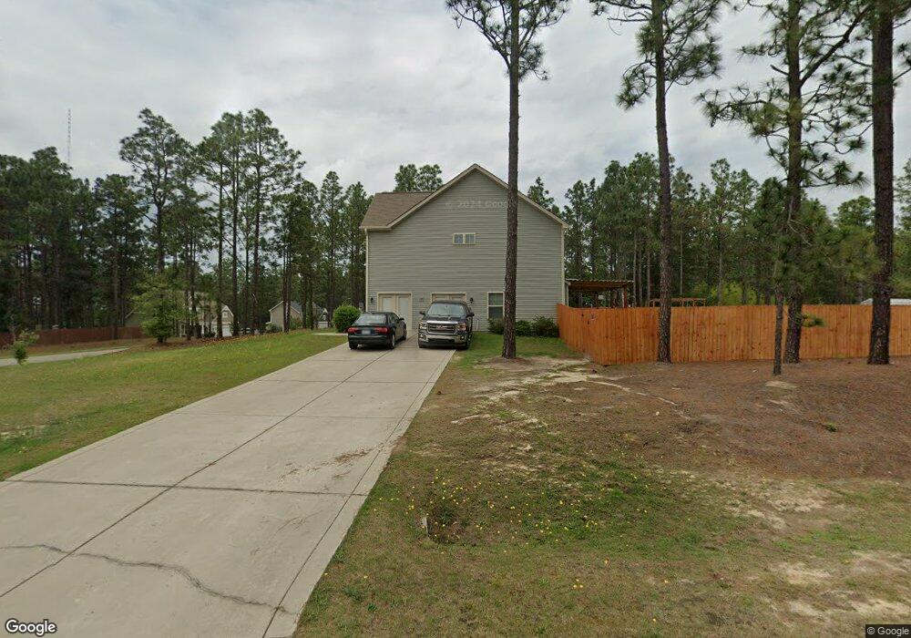
1080 Whitney Dr Aberdeen, NC 28315
Estimated Value: $416,000 - $449,000
4
Beds
4
Baths
2,710
Sq Ft
$160/Sq Ft
Est. Value
About This Home
This home is located at 1080 Whitney Dr, Aberdeen, NC 28315 and is currently estimated at $433,968, approximately $160 per square foot. 1080 Whitney Dr is a home with nearby schools including Aberdeen Elementary School, Southern Middle School, and Pinecrest High School.
Ownership History
Date
Name
Owned For
Owner Type
Purchase Details
Closed on
Oct 1, 2021
Sold by
Stac B Lp
Bought by
Mills Kenia
Current Estimated Value
Home Financials for this Owner
Home Financials are based on the most recent Mortgage that was taken out on this home.
Original Mortgage
$89,900
Outstanding Balance
$81,980
Interest Rate
2.8%
Mortgage Type
New Conventional
Estimated Equity
$351,988
Purchase Details
Closed on
Jun 27, 2018
Sold by
H & H Constructors Inc
Bought by
Stac B Lp
Purchase Details
Closed on
Oct 29, 2014
Sold by
J Speight Investments Of Moore County Ll
Bought by
H & H Construction Inc
Create a Home Valuation Report for This Property
The Home Valuation Report is an in-depth analysis detailing your home's value as well as a comparison with similar homes in the area
Home Values in the Area
Average Home Value in this Area
Purchase History
| Date | Buyer | Sale Price | Title Company |
|---|---|---|---|
| Mills Kenia | $290,000 | Sourcepoint | |
| Mills Kenia | $290,000 | None Listed On Document | |
| Stac B Lp | $235,000 | None Available | |
| H & H Construction Inc | $292,500 | None Available |
Source: Public Records
Mortgage History
| Date | Status | Borrower | Loan Amount |
|---|---|---|---|
| Open | Mills Kenia | $89,900 | |
| Closed | Mills Kenia | $89,900 |
Source: Public Records
Tax History Compared to Growth
Tax History
| Year | Tax Paid | Tax Assessment Tax Assessment Total Assessment is a certain percentage of the fair market value that is determined by local assessors to be the total taxable value of land and additions on the property. | Land | Improvement |
|---|---|---|---|---|
| 2024 | $2,900 | $377,900 | $45,000 | $332,900 |
| 2023 | $2,976 | $377,900 | $45,000 | $332,900 |
| 2022 | $2,616 | $257,710 | $32,000 | $225,710 |
| 2021 | $2,680 | $257,710 | $32,000 | $225,710 |
| 2020 | $2,706 | $257,710 | $32,000 | $225,710 |
| 2019 | $2,706 | $257,710 | $32,000 | $225,710 |
| 2018 | $2,265 | $206,510 | $25,000 | $181,510 |
| 2017 | $2,242 | $206,510 | $25,000 | $181,510 |
| 2015 | $229 | $206,510 | $25,000 | $181,510 |
| 2014 | -- | $0 | $0 | $0 |
Source: Public Records
Map
Nearby Homes
- 1155 Whitney Dr
- 812 Winds Way
- 816 Winds Way
- 804 Winds Way
- 4205 Irwin Dr
- 909 Winds Way
- 835 Lake Dornoch Dr
- 855 Lake Dornoch Dr
- 668 Wilder Bloom Path
- WILMINGTON Plan at Martin Farms
- GALEN Plan at Martin Farms
- PEARSON Plan at Martin Farms - The Townes
- CALI Plan at Martin Farms
- HAYDEN Plan at Martin Farms
- 122 Forest Dr
- 230 Paulson Ct
- 220 Paulson Ct
- 235 Paulson Ct
- 300 Sloan Ln
- 305 Sloan Ln