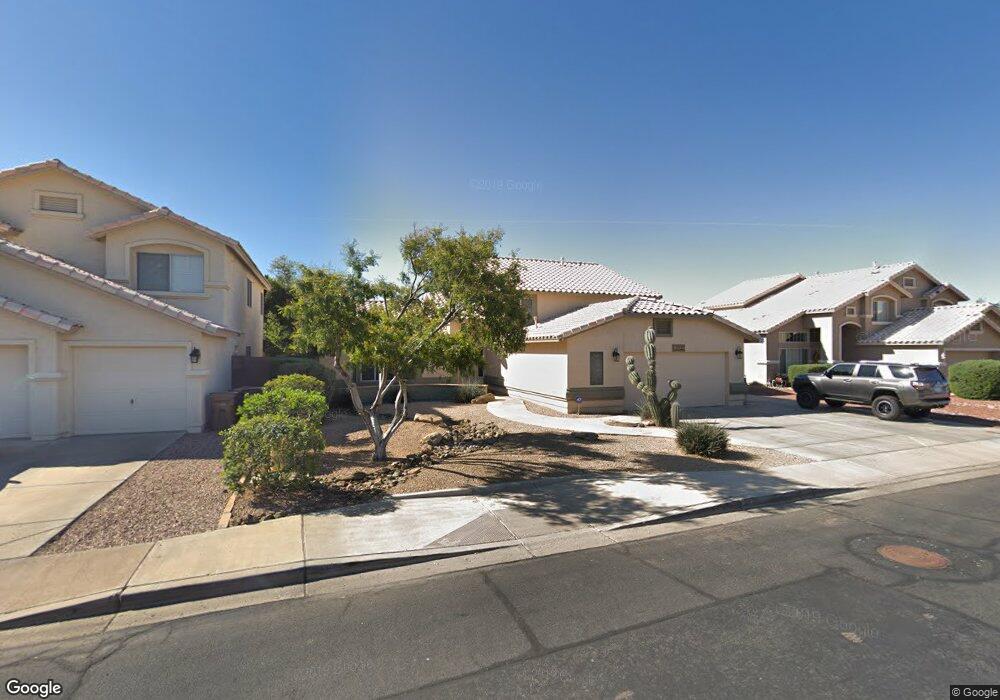
10805 W Adam Ave Sun City, AZ 85373
Estimated Value: $500,756 - $584,000
4
Beds
3
Baths
2,568
Sq Ft
$218/Sq Ft
Est. Value
About This Home
This home is located at 10805 W Adam Ave, Sun City, AZ 85373 and is currently estimated at $560,689, approximately $218 per square foot. 10805 W Adam Ave is a home located in Maricopa County with nearby schools including Parkridge Elementary School, Sunrise Mountain High School, and Candeo Peoria.
Ownership History
Date
Name
Owned For
Owner Type
Purchase Details
Closed on
Jun 24, 2024
Sold by
Sutton Jason James and Sutton Nichelle Elaine
Bought by
Sutton Family Limited Revocable Living Trust
Current Estimated Value
Purchase Details
Closed on
Jul 24, 2014
Sold by
Thomas Theresa Kay
Bought by
Sutton Jason James and Sutton Nichelle Elaine
Home Financials for this Owner
Home Financials are based on the most recent Mortgage that was taken out on this home.
Original Mortgage
$253,795
Interest Rate
4.37%
Mortgage Type
FHA
Purchase Details
Closed on
Jun 8, 2009
Sold by
Thomas Theresa Kay
Bought by
Thomas Theresa Kay and Theresa Kay Thomas Trust
Home Financials for this Owner
Home Financials are based on the most recent Mortgage that was taken out on this home.
Original Mortgage
$203,000
Interest Rate
4.82%
Mortgage Type
Purchase Money Mortgage
Purchase Details
Closed on
Sep 20, 2005
Sold by
Thomas Theresa K
Bought by
Thomas Theresa Kay and Theresa Kay Thomas Trust
Home Financials for this Owner
Home Financials are based on the most recent Mortgage that was taken out on this home.
Original Mortgage
$198,300
Interest Rate
6.12%
Mortgage Type
Purchase Money Mortgage
Purchase Details
Closed on
Sep 14, 2005
Sold by
Thomas Theresa Kay
Bought by
Thomas Theresa Kay and Theresa Kay Thomas Trust
Home Financials for this Owner
Home Financials are based on the most recent Mortgage that was taken out on this home.
Original Mortgage
$198,300
Interest Rate
6.12%
Mortgage Type
Purchase Money Mortgage
Purchase Details
Closed on
Aug 20, 2001
Sold by
Alm Mitchell R and Alm Roxanne
Bought by
Thomas Theresa Kay
Home Financials for this Owner
Home Financials are based on the most recent Mortgage that was taken out on this home.
Original Mortgage
$157,200
Interest Rate
7.21%
Purchase Details
Closed on
Oct 31, 1997
Sold by
Marlor Land Company Inc
Bought by
Alm Mitchell R and Alm Roxanne
Home Financials for this Owner
Home Financials are based on the most recent Mortgage that was taken out on this home.
Original Mortgage
$139,650
Interest Rate
7.36%
Mortgage Type
New Conventional
Purchase Details
Closed on
May 7, 1997
Sold by
Security Title Agency
Bought by
Marlor Land Company Inc
Create a Home Valuation Report for This Property
The Home Valuation Report is an in-depth analysis detailing your home's value as well as a comparison with similar homes in the area
Home Values in the Area
Average Home Value in this Area
Purchase History
| Date | Buyer | Sale Price | Title Company |
|---|---|---|---|
| Sutton Family Limited Revocable Living Trust | -- | None Listed On Document | |
| Sutton Jason James | $263,000 | North American Title Company | |
| Thomas Theresa Kay | -- | Accommodation | |
| Thomas Theresa Kay | -- | Empire West Title Agency Llc | |
| Thomas Theresa Kay | -- | -- | |
| Thomas Theresa Kay | -- | Capital Title Agency Inc | |
| Thomas Theresa Kay | $196,500 | Transnation Title Insurance | |
| Alm Mitchell R | $147,000 | Security Title Agency | |
| Marlor Land Company Inc | $22,500 | Security Title | |
| Marlor Land Company Inc | $45,000 | Security Title |
Source: Public Records
Mortgage History
| Date | Status | Borrower | Loan Amount |
|---|---|---|---|
| Previous Owner | Sutton Jason James | $253,795 | |
| Previous Owner | Thomas Theresa Kay | $203,000 | |
| Previous Owner | Thomas Theresa Kay | $198,300 | |
| Previous Owner | Thomas Theresa Kay | $157,200 | |
| Previous Owner | Alm Mitchell R | $139,650 |
Source: Public Records
Tax History Compared to Growth
Tax History
| Year | Tax Paid | Tax Assessment Tax Assessment Total Assessment is a certain percentage of the fair market value that is determined by local assessors to be the total taxable value of land and additions on the property. | Land | Improvement |
|---|---|---|---|---|
| 2025 | $1,931 | $24,458 | -- | -- |
| 2024 | $1,899 | $23,293 | -- | -- |
| 2023 | $1,899 | $38,680 | $7,730 | $30,950 |
| 2022 | $1,859 | $30,080 | $6,010 | $24,070 |
| 2021 | $1,988 | $28,200 | $5,640 | $22,560 |
| 2020 | $2,007 | $26,550 | $5,310 | $21,240 |
| 2019 | $1,944 | $24,330 | $4,860 | $19,470 |
| 2018 | $1,871 | $22,800 | $4,560 | $18,240 |
| 2017 | $1,873 | $21,310 | $4,260 | $17,050 |
| 2016 | $1,827 | $20,060 | $4,010 | $16,050 |
| 2015 | $1,729 | $18,210 | $3,640 | $14,570 |
Source: Public Records
Map
Nearby Homes
- 10806 W Adam Ave
- 10816 W Quail Ave
- 10816 W Deanna Dr
- 10672 W Ross Ave
- 20957 N 107th Dr
- 10549 W Albert Ln
- 20769 N 106th Ln
- 10728 W Irma Ln
- 10722 W Irma Ln
- 10528 W Potter Dr
- 20670 N 105th Dr
- 10630 W Mohawk Ln
- 10446 W Lone Cactus Dr
- 10368 W Ross Ave
- 20641 N 110th Ave
- 20360 N 106th Ln
- 20615 N 105th Ave
- 10824 W Sands Dr
- 21479 N 104th Dr
- 10763 W Runion Dr
- 10753 W Adam Ave
- 10811 W Adam Ave
- 10758 W Quail Ave
- 10752 W Quail Ave
- 10747 W Adam Ave
- 10817 W Adam Ave
- 10764 W Quail Ave
- 10746 W Quail Ave
- 21355 N 108th Ave
- 10812 W Adam Ave
- 10770 W Quail Ave
- 10770 W Quail Ave --
- 10741 W Adam Ave
- 10823 W Adam Ave
- 10740 W Quail Ave
- 21365 N 108th Ave
- 10818 W Adam Ave
- 10804 W Quail Ave
- 21320 N 107th Dr
- 21360 N 107th Dr