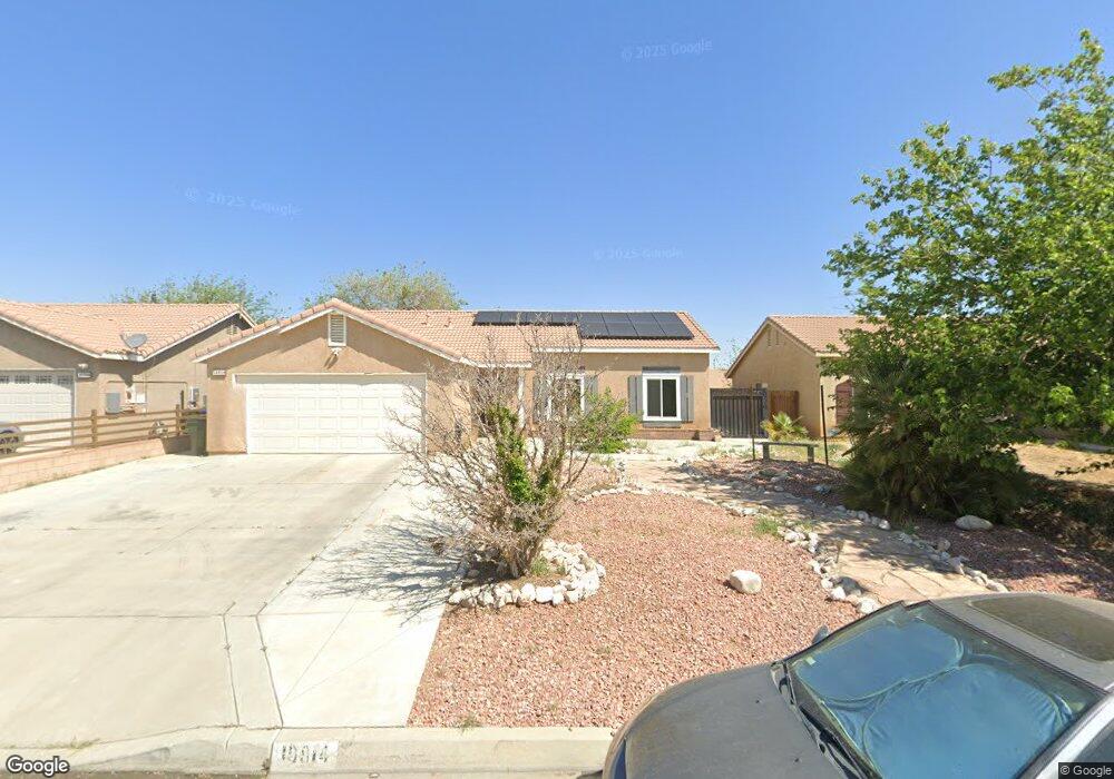
10814 Pershing St Adelanto, CA 92301
Mesa Linda NeighborhoodEstimated Value: $367,000 - $376,650
4
Beds
2
Baths
1,398
Sq Ft
$266/Sq Ft
Est. Value
About This Home
This home is located at 10814 Pershing St, Adelanto, CA 92301 and is currently estimated at $371,663, approximately $265 per square foot. 10814 Pershing St is a home located in San Bernardino County with nearby schools including Theodore Vick Elementary School, Columbia Middle School, and Adelanto High School.
Ownership History
Date
Name
Owned For
Owner Type
Purchase Details
Closed on
Jan 24, 2020
Sold by
Koons Daryl O and Koons Evelyn
Bought by
Mata Yair G and Mata Armida
Current Estimated Value
Home Financials for this Owner
Home Financials are based on the most recent Mortgage that was taken out on this home.
Original Mortgage
$223,870
Outstanding Balance
$197,874
Interest Rate
3.62%
Mortgage Type
FHA
Estimated Equity
$173,789
Create a Home Valuation Report for This Property
The Home Valuation Report is an in-depth analysis detailing your home's value as well as a comparison with similar homes in the area
Home Values in the Area
Average Home Value in this Area
Purchase History
| Date | Buyer | Sale Price | Title Company |
|---|---|---|---|
| Mata Yair G | $228,000 | Ticor Title |
Source: Public Records
Mortgage History
| Date | Status | Borrower | Loan Amount |
|---|---|---|---|
| Open | Mata Yair G | $223,870 |
Source: Public Records
Tax History
| Year | Tax Paid | Tax Assessment Tax Assessment Total Assessment is a certain percentage of the fair market value that is determined by local assessors to be the total taxable value of land and additions on the property. | Land | Improvement |
|---|---|---|---|---|
| 2025 | $3,456 | $249,352 | $49,870 | $199,482 |
| 2024 | $3,201 | $244,463 | $48,892 | $195,571 |
| 2023 | $3,224 | $239,669 | $47,933 | $191,736 |
| 2022 | $3,086 | $234,969 | $46,993 | $187,976 |
| 2021 | $3,244 | $230,362 | $46,072 | $184,290 |
| 2020 | $2,039 | $135,732 | $32,812 | $102,920 |
| 2019 | $274 | $133,071 | $32,169 | $100,902 |
| 2018 | $439 | $130,462 | $31,538 | $98,924 |
| 2017 | $421 | $127,904 | $30,920 | $96,984 |
| 2016 | $412 | $125,396 | $30,314 | $95,082 |
| 2015 | $391 | $123,513 | $29,859 | $93,654 |
| 2014 | $399 | $121,093 | $29,274 | $91,819 |
Source: Public Records
Map
Nearby Homes
- 10776 Tolliver St
- 14753 Kimberly St
- 14827 Kimberly St
- 10912 Pershing Dr
- 10842 Wakefield St E
- 10626 Villa St
- 10982 Sherman Way
- 0 Cypress Rd
- 14724 Cypress Rd
- 10611 Plainfield St
- 11068 Tamarisk Rd
- 10580 Wakefield St E
- 14626 Allison St
- 10595 Moorfield Cir
- 10851 Dove Ln
- 11184 Villa St
- 10965 Remington St
- 11224 Westbrook Dr
- 15173 Hill Way
- 11017 Mckinley Ave
- 10824 Pershing St
- 10804 Pershing St
- 10813 Pemberton St
- 10832 Pershing St
- 10796 Pershing St
- 10805 Pemberton St
- 10823 Pemberton St
- 10833 Pemberton St
- 10795 Pemberton St
- 10813 Pershing St
- 10842 Pershing St
- 10786 Pershing St
- 10823 Pershing St
- 10805 Pershing St
- 10833 Pershing St
- 10843 Pemberton St
- 10785 Pemberton St
- 10795 Pershing St
- 10852 Pershing St
- 10776 Pershing St
Your Personal Tour Guide
Ask me questions while you tour the home.