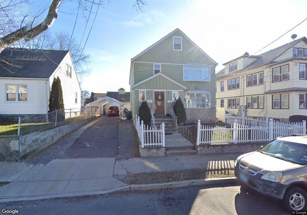
1083 Capitol Ave Unit 1085 Bridgeport, CT 06606
Brooklawn-Saint Vincent NeighborhoodEstimated Value: $460,972 - $578,000
4
Beds
2
Baths
3,233
Sq Ft
$155/Sq Ft
Est. Value
About This Home
This home is located at 1083 Capitol Ave Unit 1085, Bridgeport, CT 06606 and is currently estimated at $500,243, approximately $154 per square foot. 1083 Capitol Ave Unit 1085 is a home located in Fairfield County with nearby schools including Madison School, Central High School, and Catholic Academy of Bridgeport-St. Raphael Academy.
Ownership History
Date
Name
Owned For
Owner Type
Purchase Details
Closed on
Aug 29, 2008
Sold by
Cagganeilo Thomas J and Cagganeiio Grace M
Bought by
Martinez Yushi A and Saiinas Kelvin O
Current Estimated Value
Home Financials for this Owner
Home Financials are based on the most recent Mortgage that was taken out on this home.
Original Mortgage
$253,521
Outstanding Balance
$166,759
Interest Rate
6.29%
Estimated Equity
$333,484
Create a Home Valuation Report for This Property
The Home Valuation Report is an in-depth analysis detailing your home's value as well as a comparison with similar homes in the area
Home Values in the Area
Average Home Value in this Area
Purchase History
| Date | Buyer | Sale Price | Title Company |
|---|---|---|---|
| Martinez Yushi A | $257,500 | -- | |
| Martinez Yushi A | $257,500 | -- |
Source: Public Records
Mortgage History
| Date | Status | Borrower | Loan Amount |
|---|---|---|---|
| Open | Martinez Yushi A | $253,521 | |
| Closed | Martinez Yushi A | $253,521 |
Source: Public Records
Tax History
| Year | Tax Paid | Tax Assessment Tax Assessment Total Assessment is a certain percentage of the fair market value that is determined by local assessors to be the total taxable value of land and additions on the property. | Land | Improvement |
|---|---|---|---|---|
| 2025 | $8,316 | $191,388 | $62,318 | $129,070 |
| 2024 | $8,316 | $191,388 | $62,318 | $129,070 |
| 2023 | $8,316 | $191,388 | $62,318 | $129,070 |
| 2022 | $8,316 | $191,388 | $62,318 | $129,070 |
| 2021 | $8,316 | $191,388 | $62,318 | $129,070 |
| 2020 | $7,802 | $144,500 | $37,760 | $106,740 |
| 2019 | $7,802 | $144,500 | $37,760 | $106,740 |
| 2018 | $7,856 | $144,500 | $37,760 | $106,740 |
| 2017 | $7,856 | $144,500 | $37,760 | $106,740 |
| 2016 | $7,856 | $144,500 | $37,760 | $106,740 |
| 2015 | $7,920 | $187,670 | $39,980 | $147,690 |
| 2014 | $7,920 | $187,670 | $39,980 | $147,690 |
Source: Public Records
Map
Nearby Homes
- 1156 Capitol Ave
- 1275 Capitol Ave
- 31 Taft Ave
- 125 Alexander Dr
- 241 Sampson St
- 1515 Capitol Ave Unit 1517
- 2625 Park Ave Unit 5S
- 2625 Park Ave Unit 9R
- 20 Amsterdam Ave Unit 2E
- 2675 Park Ave Unit 3
- 2675 Park Ave Unit 22
- 92 Lincoln Ave
- 1440 Wood Ave
- 78 Fairmount Ave
- 248 Salem St
- 51 Marion St Unit 55
- 191 Oak St
- 125 Garden Dr
- 123 Harlem Ave
- 105 Tremont Ave Unit E
- 1103 Capitol Ave Unit 1105
- 1103 Capitol Ave Unit 2
- 1075 Capitol Ave
- 1084 Capitol Ave Unit 1086
- 1093 Capitol Ave Unit 1095
- 1090 Capitol Ave Unit 1092
- 1105 Capitol Ave Unit 1
- 39 Pearmain Rd
- 1074 Capitol Ave
- 214 Cleveland Ave
- 226 Cleveland Ave
- 1060 Capitol Ave
- 1102 Capitol Ave
- 1102 Capitol Ave Unit 1
- 1065 Capitol Ave Unit 1067
- 1100 Capitol Ave Unit 1102
- 1100 Capitol Ave Unit 2
- 1043 Capitol Ave Unit 1045
- 1050 Capitol Ave Unit 1052
- 236 Cleveland Ave