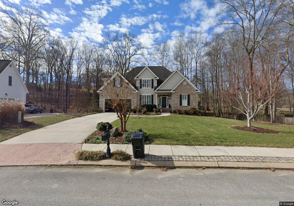
1083 Harbor Landing Dr Soddy Daisy, TN 37379
Estimated Value: $446,648 - $633,000
--
Bed
--
Bath
2,338
Sq Ft
$227/Sq Ft
Est. Value
About This Home
This home is located at 1083 Harbor Landing Dr, Soddy Daisy, TN 37379 and is currently estimated at $529,662, approximately $226 per square foot. 1083 Harbor Landing Dr is a home located in Hamilton County.
Ownership History
Date
Name
Owned For
Owner Type
Purchase Details
Closed on
Dec 17, 2004
Sold by
Cooper Construction Co Inc
Bought by
Benecke Janet A
Current Estimated Value
Purchase Details
Closed on
Apr 22, 2004
Sold by
Luttrell George W
Bought by
Cooper Construction Co Inc
Home Financials for this Owner
Home Financials are based on the most recent Mortgage that was taken out on this home.
Original Mortgage
$200,000
Interest Rate
5.38%
Mortgage Type
Unknown
Create a Home Valuation Report for This Property
The Home Valuation Report is an in-depth analysis detailing your home's value as well as a comparison with similar homes in the area
Home Values in the Area
Average Home Value in this Area
Purchase History
| Date | Buyer | Sale Price | Title Company |
|---|---|---|---|
| Benecke Janet A | $240,000 | Northgate Title Escrow Inc | |
| Cooper Construction Co Inc | $35,000 | Northgate Title Escrow Inc |
Source: Public Records
Mortgage History
| Date | Status | Borrower | Loan Amount |
|---|---|---|---|
| Previous Owner | Cooper Construction Co Inc | $200,000 |
Source: Public Records
Tax History Compared to Growth
Tax History
| Year | Tax Paid | Tax Assessment Tax Assessment Total Assessment is a certain percentage of the fair market value that is determined by local assessors to be the total taxable value of land and additions on the property. | Land | Improvement |
|---|---|---|---|---|
| 2024 | $1,783 | $79,675 | $0 | $0 |
| 2023 | $2,681 | $79,675 | $0 | $0 |
| 2022 | $2,681 | $79,675 | $0 | $0 |
| 2021 | $2,681 | $79,675 | $0 | $0 |
| 2020 | $3,165 | $76,650 | $0 | $0 |
| 2019 | $3,165 | $76,650 | $0 | $0 |
| 2018 | $3,165 | $76,650 | $0 | $0 |
| 2017 | $3,165 | $76,650 | $0 | $0 |
| 2016 | $2,972 | $0 | $0 | $0 |
| 2015 | $2,972 | $71,950 | $0 | $0 |
| 2014 | $2,972 | $0 | $0 | $0 |
Source: Public Records
Map
Nearby Homes
- 11312 Hixson Pike
- 11652 Hixson Pike
- 11636 Holly Cir
- 1055 Apollo Dr
- 11008 Lovell Rd
- 11734 Armstrong Rd
- 11213 Dayton Pike
- 11317 Cape View
- 1235 Bentley Ln
- 11570 Armstrong Rd
- 10627 Jeneva Ln
- 191 Depot St
- 10496 Sovereign Pointe Dr
- 176 Depot St
- 10428 Jeneva Ln
- 345 Ducktown St
- 168 Depot St
- 155 Depot St
- 1708 Restful Dr
- 11326 Old Dayton Pike
- 1081 Harbor Landing Dr
- 1085 Harbor Landing Dr
- 972 Clift Cave Rd
- 1087 Harbor Landing Dr
- 910 Clift Eldridge Rd
- 1084 Harbor Landing Dr
- 1086 Harbor Landing Dr
- 976 Clift Cave Rd
- 1079 Harbor Landing Dr
- 805 Harbor Landing Dr
- 980 Clift Cave Rd
- 1082 Harbor Landing Dr
- 1088 Harbor Landing Dr
- 1075 Harbor Landing Dr
- 984 Clift Cave Rd
- 11251 Fritts Rd
- 1080 Harbor Landing Dr
- 1090 Harbor Landing Dr
- 988 Clift Cave Rd
- 1008 Clift Cave Rd