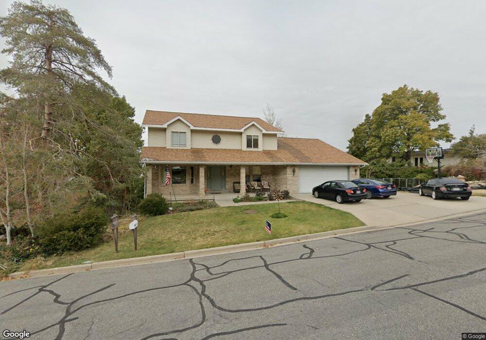
1085 Oakridge Dr Centerville, UT 84014
Estimated Value: $625,000 - $816,220
6
Beds
4
Baths
4,403
Sq Ft
$169/Sq Ft
Est. Value
About This Home
This home is located at 1085 Oakridge Dr, Centerville, UT 84014 and is currently estimated at $744,055, approximately $168 per square foot. 1085 Oakridge Dr is a home located in Davis County with nearby schools including Stewart Elementary School, Centerville Jr High, and Viewmont High School.
Ownership History
Date
Name
Owned For
Owner Type
Purchase Details
Closed on
Mar 13, 2023
Sold by
Kenneth A Major Family Living Trust
Bought by
Jill C Major Family Living Trust
Current Estimated Value
Purchase Details
Closed on
Jun 25, 2008
Sold by
Major Jill C
Bought by
Major Jill C
Purchase Details
Closed on
Feb 23, 2004
Sold by
Major Jill C
Bought by
Major Jill C
Home Financials for this Owner
Home Financials are based on the most recent Mortgage that was taken out on this home.
Original Mortgage
$146,600
Interest Rate
4.95%
Mortgage Type
New Conventional
Purchase Details
Closed on
Oct 7, 1999
Sold by
Major Kenneth A and Major Jill C
Bought by
Major Jill C
Create a Home Valuation Report for This Property
The Home Valuation Report is an in-depth analysis detailing your home's value as well as a comparison with similar homes in the area
Purchase History
| Date | Buyer | Sale Price | Title Company |
|---|---|---|---|
| Jill C Major Family Living Trust | -- | None Listed On Document | |
| Major Jill C | -- | None Available | |
| Major Jill C | -- | Sundance Title Agency | |
| Major Jill C | -- | Sundance Title Agency | |
| Major Jill C | -- | -- | |
| Major Kenneth A | -- | -- |
Source: Public Records
Mortgage History
| Date | Status | Borrower | Loan Amount |
|---|---|---|---|
| Previous Owner | Major Jill C | $146,600 |
Source: Public Records
Tax History
| Year | Tax Paid | Tax Assessment Tax Assessment Total Assessment is a certain percentage of the fair market value that is determined by local assessors to be the total taxable value of land and additions on the property. | Land | Improvement |
|---|---|---|---|---|
| 2025 | $4,186 | $400,400 | $186,020 | $214,380 |
| 2024 | $4,155 | $404,249 | $170,838 | $233,411 |
| 2023 | $3,783 | $365,750 | $151,494 | $214,255 |
| 2022 | $4,017 | $707,000 | $254,645 | $452,355 |
| 2021 | $3,601 | $543,000 | $219,217 | $323,783 |
| 2020 | $3,111 | $469,000 | $211,360 | $257,640 |
| 2019 | $3,165 | $466,000 | $202,837 | $263,163 |
| 2018 | $2,963 | $431,000 | $187,729 | $243,271 |
| 2016 | $2,564 | $207,240 | $68,170 | $139,070 |
| 2015 | $2,370 | $180,730 | $68,170 | $112,560 |
| 2014 | $2,014 | $157,160 | $67,980 | $89,180 |
| 2013 | -- | $164,930 | $50,503 | $114,427 |
Source: Public Records
Map
Nearby Homes
- 984 N 500 E
- 1290 Oakridge Dr
- 1366 Cottonwood Dr
- 563 N 220 E
- 66 Brookside Ln
- 775 Pheasantbrook Cir
- 145 Ford Canyon Dr
- 380 E 400 N
- 271 Brookfield Ln
- 252 N 400 E
- 371 W 1125 N
- 292 W 680 N
- 781 Pheasantbrook Dr
- 290 W 1350 N
- 281 W 650 N Unit B
- 282 W 605 N Unit A
- 282 W 605 N Unit I
- 303 W 650 N Unit I
- 1238 N 450 W
- 56 W 200 N
Your Personal Tour Guide
Ask me questions while you tour the home.