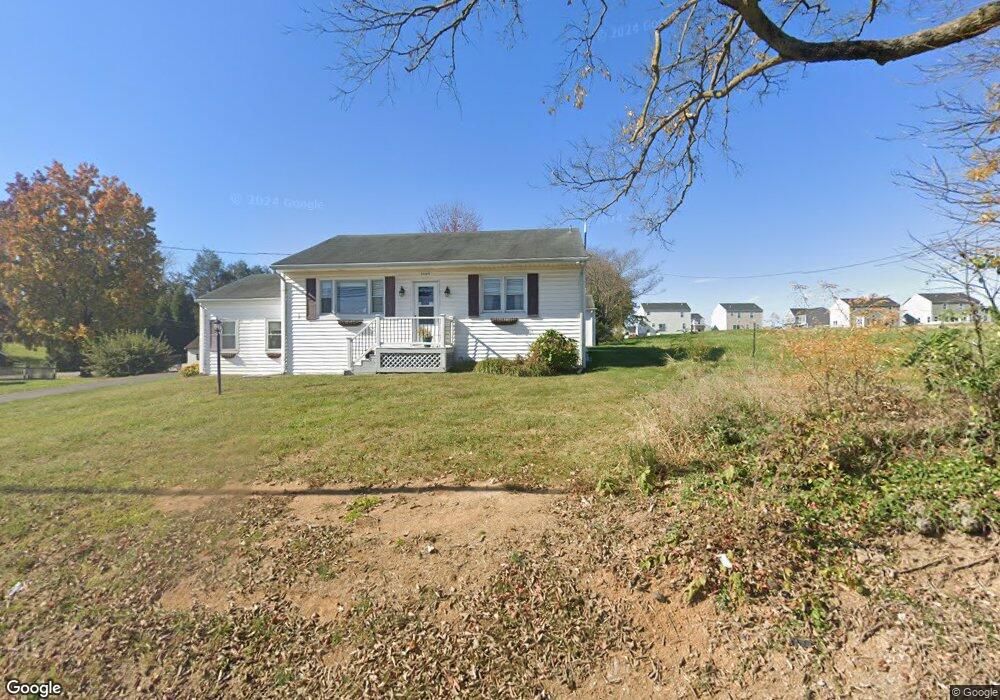
1089 N Mildred St Ranson, WV 25438
Estimated Value: $235,000 - $264,411
2
Beds
2
Baths
1,242
Sq Ft
$202/Sq Ft
Est. Value
About This Home
This home is located at 1089 N Mildred St, Ranson, WV 25438 and is currently estimated at $251,353, approximately $202 per square foot. 1089 N Mildred St is a home located in Jefferson County with nearby schools including Ranson Elementary School, Wildwood Middle School, and Jefferson High School.
Ownership History
Date
Name
Owned For
Owner Type
Purchase Details
Closed on
Jul 18, 2011
Sold by
Donivan Lori J
Bought by
Donivan Lori J and Young Debra K
Current Estimated Value
Purchase Details
Closed on
Aug 8, 2006
Sold by
Donivan Norma J
Bought by
Donivan Lori J
Create a Home Valuation Report for This Property
The Home Valuation Report is an in-depth analysis detailing your home's value as well as a comparison with similar homes in the area
Home Values in the Area
Average Home Value in this Area
Purchase History
| Date | Buyer | Sale Price | Title Company |
|---|---|---|---|
| Donivan Lori J | $50,000 | None Available | |
| Donivan Lori J | -- | None Available |
Source: Public Records
Tax History Compared to Growth
Tax History
| Year | Tax Paid | Tax Assessment Tax Assessment Total Assessment is a certain percentage of the fair market value that is determined by local assessors to be the total taxable value of land and additions on the property. | Land | Improvement |
|---|---|---|---|---|
| 2025 | $1,290 | $111,000 | $53,800 | $57,200 |
| 2024 | $1,239 | $105,800 | $53,800 | $52,000 |
| 2023 | $1,236 | $105,800 | $53,800 | $52,000 |
| 2022 | $1,182 | $99,200 | $53,800 | $45,400 |
| 2021 | $1,052 | $86,600 | $46,400 | $40,200 |
| 2020 | $846 | $74,300 | $31,800 | $42,500 |
| 2019 | $811 | $69,900 | $26,900 | $43,000 |
| 2018 | $804 | $68,400 | $26,900 | $41,500 |
| 2017 | $814 | $69,300 | $26,900 | $42,400 |
| 2016 | $732 | $62,500 | $19,600 | $42,900 |
| 2015 | $627 | $53,200 | $19,600 | $33,600 |
| 2014 | $561 | $47,700 | $13,600 | $34,100 |
Source: Public Records
Map
Nearby Homes
- St Paul Plan at Huntwell West - Townhomes
- Tulip Plan at Huntwell West - Townhomes
- 197 Ellery St
- Dallas Plan at Huntwell West
- Avalon Plan at Huntwell West
- Rockford Plan at Huntwell West
- Oleander Plan at Aspire at Huntwell West
- Water Lily Plan at Aspire at Huntwell West
- Sweet Pea Plan at Aspire at Huntwell West
- 0 Jouett St
- 80 Jouett St
- Homesite 2233 Huntwell West Blvd
- 73 Hopkins St
- 6 Sumter Ave
- HomeSite 1999 Huntwell West Ave
- 153 Huntwell Ave W
- 0 Sumter Ave
- 200 Huntwell Ave W
- 132 Monroe Ave
- 221 Huntwell West Ave
- 1136 N Mildred St
- 135 Circle St
- 602604 N Mildred St
- 1051 N Mildred St
- 1108 N Mildred St
- 1041 N Mildred St
- 42 Circle St
- 1029 N Mildred St
- 62 Circle St
- 0 Peters Ave Unit WVJF2018930
- 0 Peters Ave Unit WVJF2017300
- 0 Peters Ave Unit WVJF2015076
- 0 Peters Ave Unit WVJF2012302
- 0 Peters Ave Unit WVJF2010290
- 0 Peters Ave Unit WVJF2008870
- 0 Peters Ave Unit WVJF2008868
- 0 Peters Ave Unit WVJF2008866
- 15 Circle St
- 35 Circle St
- 49 Circle St