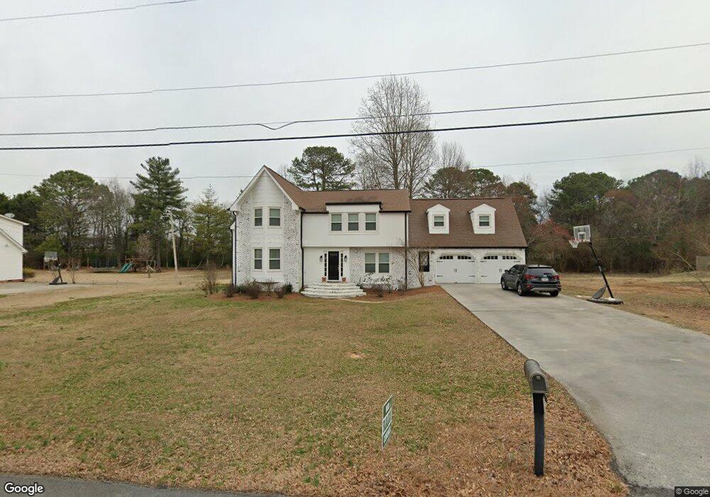
109 Derby Ln Calhoun, GA 30701
Estimated Value: $352,000 - $475,000
4
Beds
3
Baths
2,582
Sq Ft
$155/Sq Ft
Est. Value
About This Home
This home is located at 109 Derby Ln, Calhoun, GA 30701 and is currently estimated at $400,185, approximately $154 per square foot. 109 Derby Ln is a home located in Gordon County with nearby schools including Calhoun Elementary School, Calhoun Middle School, and Calhoun High School.
Ownership History
Date
Name
Owned For
Owner Type
Purchase Details
Closed on
Dec 28, 2009
Sold by
Bryson Milton E
Bought by
Hurd Robert T and Hurd Emily K
Current Estimated Value
Home Financials for this Owner
Home Financials are based on the most recent Mortgage that was taken out on this home.
Original Mortgage
$175,757
Outstanding Balance
$111,876
Interest Rate
4.75%
Mortgage Type
FHA
Estimated Equity
$288,309
Purchase Details
Closed on
Oct 11, 2005
Sold by
Hughey Phillip M
Bought by
Bryson Milton E and Bryson Carol
Purchase Details
Closed on
Aug 22, 2001
Sold by
Phillips Ray O and Phillips Gail M
Bought by
Hughey Phillip M and Hughey Jennifer
Purchase Details
Closed on
Dec 22, 1994
Bought by
Phillips Ray O and Phillips Gail M
Create a Home Valuation Report for This Property
The Home Valuation Report is an in-depth analysis detailing your home's value as well as a comparison with similar homes in the area
Purchase History
| Date | Buyer | Sale Price | Title Company |
|---|---|---|---|
| Hurd Robert T | $179,000 | -- | |
| Bryson Milton E | $159,228 | -- | |
| Hughey Phillip M | $180,000 | -- | |
| Phillips Ray O | $119,000 | -- |
Source: Public Records
Mortgage History
| Date | Status | Borrower | Loan Amount |
|---|---|---|---|
| Open | Hurd Robert T | $175,757 |
Source: Public Records
Tax History
| Year | Tax Paid | Tax Assessment Tax Assessment Total Assessment is a certain percentage of the fair market value that is determined by local assessors to be the total taxable value of land and additions on the property. | Land | Improvement |
|---|---|---|---|---|
| 2025 | $2,835 | $115,240 | $5,600 | $109,640 |
| 2023 | $2,645 | $94,720 | $5,600 | $89,120 |
| 2022 | $823 | $88,480 | $5,600 | $82,880 |
| 2021 | $2,210 | $74,880 | $5,600 | $69,280 |
| 2020 | $2,242 | $75,360 | $5,600 | $69,760 |
| 2019 | $2,239 | $75,360 | $5,600 | $69,760 |
| 2018 | $655 | $70,000 | $5,600 | $64,400 |
| 2017 | $631 | $66,240 | $5,600 | $60,640 |
| 2016 | $633 | $66,240 | $5,600 | $60,640 |
| 2015 | $629 | $65,000 | $5,600 | $59,400 |
| 2014 | $598 | $62,733 | $5,600 | $57,133 |
Source: Public Records
Map
Nearby Homes
- 115 Windsor Dr
- 140 Cambridge Ct
- 127 Windsor Dr
- 115 Devonwood Dr
- 129 Derby Ln
- 114 Lindsey Ct NE
- 326 Curtis Pkwy NE
- 118 Garden Lake Dr
- 123 Waterside Ridge
- 110 Waterside Ridge
- 136 Meadow Ln
- 215 NW Briar Ridge Rd
- 2148 Red Bud Rd NE
- 201 Crestmont Dr
- 133 Kentucky Dr NE
- 1125 Dews Pond Rd SE
- 103 Mims Dr
- 301 Briarwood Dr
- 121 Hunt Dr
- 301 Windy Hill Dr
Your Personal Tour Guide
Ask me questions while you tour the home.