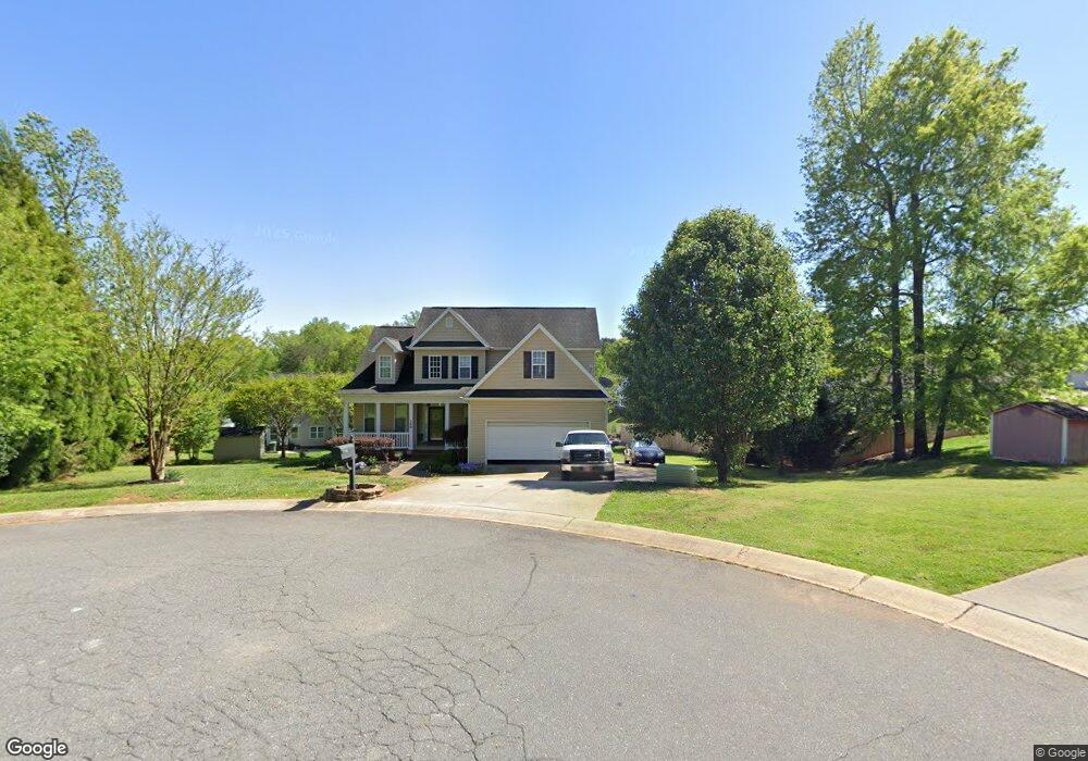
109 High Ridge Ct W Mount Holly, NC 28120
Estimated Value: $409,647 - $487,000
4
Beds
3
Baths
2,289
Sq Ft
$196/Sq Ft
Est. Value
About This Home
This home is located at 109 High Ridge Ct W, Mount Holly, NC 28120 and is currently estimated at $448,912, approximately $196 per square foot. 109 High Ridge Ct W is a home located in Gaston County with nearby schools including Rankin Elementary School, Mount Holly Middle School, and Stuart W. Cramer High School.
Ownership History
Date
Name
Owned For
Owner Type
Purchase Details
Closed on
Aug 22, 2013
Sold by
Rockey Robert and Johnson Rockey Stephanie
Bought by
Thurston Nicholas E and Lewis Thurston Kathryn
Current Estimated Value
Home Financials for this Owner
Home Financials are based on the most recent Mortgage that was taken out on this home.
Original Mortgage
$130,500
Outstanding Balance
$97,048
Interest Rate
4.39%
Mortgage Type
New Conventional
Estimated Equity
$351,864
Purchase Details
Closed on
Sep 29, 2006
Sold by
Reeger Builders Inc
Bought by
Rockey Robert and Johnson Rockey Stephane
Home Financials for this Owner
Home Financials are based on the most recent Mortgage that was taken out on this home.
Original Mortgage
$178,000
Interest Rate
6.48%
Mortgage Type
Purchase Money Mortgage
Create a Home Valuation Report for This Property
The Home Valuation Report is an in-depth analysis detailing your home's value as well as a comparison with similar homes in the area
Home Values in the Area
Average Home Value in this Area
Purchase History
| Date | Buyer | Sale Price | Title Company |
|---|---|---|---|
| Thurston Nicholas E | $145,000 | None Available | |
| Rockey Robert | $222,500 | None Available |
Source: Public Records
Mortgage History
| Date | Status | Borrower | Loan Amount |
|---|---|---|---|
| Open | Thurston Nicholas E | $130,500 | |
| Previous Owner | Rockey Robert | $178,000 | |
| Previous Owner | Rockey Robert | $44,500 |
Source: Public Records
Tax History Compared to Growth
Tax History
| Year | Tax Paid | Tax Assessment Tax Assessment Total Assessment is a certain percentage of the fair market value that is determined by local assessors to be the total taxable value of land and additions on the property. | Land | Improvement |
|---|---|---|---|---|
| 2025 | $4,217 | $419,970 | $33,000 | $386,970 |
| 2024 | $4,217 | $419,970 | $33,000 | $386,970 |
| 2023 | $4,263 | $419,970 | $33,000 | $386,970 |
| 2022 | $3,395 | $262,180 | $24,000 | $238,180 |
| 2021 | $3,448 | $262,180 | $24,000 | $238,180 |
| 2019 | $3,474 | $262,180 | $24,000 | $238,180 |
| 2018 | $2,798 | $199,829 | $24,000 | $175,829 |
| 2017 | $2,798 | $199,829 | $24,000 | $175,829 |
| 2016 | $1,739 | $199,829 | $0 | $0 |
| 2014 | $1,780 | $204,601 | $30,000 | $174,601 |
Source: Public Records
Map
Nearby Homes
- 221 Deerfield Dr
- 128 Birchwood Ct
- 732 Deerfield Dr
- 1024 Old Mountain View Rd
- 305 Ridge Dr
- 120 Rippling Water Dr
- 1045 Hoover Ave
- 120 Abernathy St
- 1015 Hoover Ave
- 1501 Old Hickory Grove Rd
- 405 Wheat Field Dr
- 308 Tall Wheat Ln
- 1611 Old Hickory Grove Rd
- 104 Pine Rd
- 440 Wheat Field Dr
- 440 Planters Way
- 433 W Central Ave
- 405 Briarwood Ct
- 441 Holly Cir
- 120 Walk A Long Way
- 105 Ridge Dr
- 105 High Ridge Ct W
- 208 Deerfield Dr
- 204 Silver Birch Ln
- 204 Deerfield Dr
- 208 Silver Birch Ln
- 212 Deerfield Dr
- 108 High Ridge Ct W
- 200 Deerfield Dr
- 212 Silver Birch Ln
- 220 Deerfield Dr
- 216 Deerfield Dr
- 224 Deerfield Dr
- 104 High Ridge Ct W
- 216 Silver Birch Ln
- 205 Deerfield Dr
- 205 Deerfield Dr Unit 87
- 300 Deerfield Dr
- 209 Deerfield Dr
- 205 Silver Birch Ln