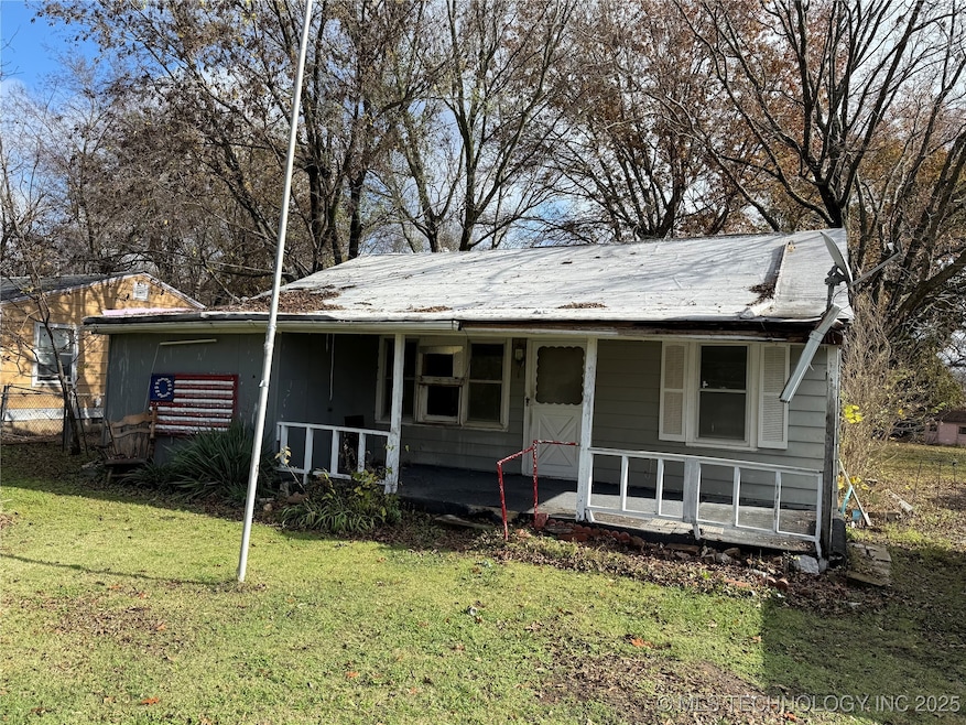
109 N Coal St Sperry, OK 74073
Estimated payment $395/month
2
Beds
2
Baths
1,968
Sq Ft
$30
Price per Sq Ft
Highlights
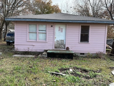
- Additional Residence on Property
- No HOA
- Shed
- Sperry Elementary School Rated A-
- Log Cabin
- Space Heater
About This Home
2 bedroom, 2 bath home in an established neighborhood

Home Details
Home Type
- Single Family
Est. Annual Taxes
- $938
Year Built
- Built in 1946
Lot Details
- 0.5 Acre Lot
- North Facing Home
Parking
- Gravel Driveway
Home Design
- Log Cabin
- Wood Frame Construction
- Fiberglass Roof
- Aluminum Siding
- Asphalt
Interior Spaces
- 1,968 Sq Ft Home
- 1-Story Property
- Aluminum Window Frames
- Carpet
- Crawl Space
- Electric Dryer Hookup
Kitchen
- Oven
- Range
- Dishwasher
- Laminate Countertops
- Disposal
Bedrooms and Bathrooms
- 2 Bedrooms
- 2 Full Bathrooms
Schools
- Sperry Elementary And Middle School
- Sperry High School
Utilities
- No Cooling
- Space Heater
- Heating System Uses Gas
- Gas Water Heater
- Cable TV Available
Additional Features
- Shed
- Additional Residence on Property
Community Details
- No Home Owners Association
- Sixkiller Addn Subdivision
Map
Create a Home Valuation Report for This Property
The Home Valuation Report is an in-depth analysis detailing your home's value as well as a comparison with similar homes in the area
Home Values in the Area
Average Home Value in this Area
Tax History
| Year | Tax Paid | Tax Assessment Tax Assessment Total Assessment is a certain percentage of the fair market value that is determined by local assessors to be the total taxable value of land and additions on the property. | Land | Improvement |
|---|---|---|---|---|
| 2024 | $891 | $8,416 | $324 | $8,092 |
| 2023 | $891 | $8,015 | $790 | $7,225 |
| 2022 | $897 | $8,015 | $790 | $7,225 |
| 2021 | $877 | $7,875 | $776 | $7,099 |
| 2020 | $837 | $7,500 | $739 | $6,761 |
| 2019 | $802 | $7,143 | $704 | $6,439 |
| 2018 | $778 | $6,930 | $683 | $6,247 |
| 2017 | $718 | $6,600 | $704 | $5,896 |
| 2016 | $715 | $6,600 | $704 | $5,896 |
| 2015 | $711 | $6,600 | $704 | $5,896 |
| 2014 | $703 | $6,600 | $704 | $5,896 |
Source: Public Records
Property History
| Date | Event | Price | List to Sale | Price per Sq Ft |
|---|---|---|---|---|
| 11/25/2025 11/25/25 | For Sale | $60,000 | -- | $30 / Sq Ft |
Source: MLS Technology
Purchase History
| Date | Type | Sale Price | Title Company |
|---|---|---|---|
| Warranty Deed | $60,000 | None Available | |
| Warranty Deed | -- | -- |
Source: Public Records
Mortgage History
| Date | Status | Loan Amount | Loan Type |
|---|---|---|---|
| Open | $41,635 | Unknown |
Source: Public Records
Source: MLS Technology
MLS Number: 2548328
APN: 63850-12-13-01590
Disclaimer: Certain information contained herein is derived from information provided by parties other than Homes.com. All information provided is deemed reliable, but is not guaranteed to be accurate and should be independently verified.
![]() IDX information is provided exclusively for personal, non-commercial use, and may not be used for any purpose other than to identify prospective properties consumers may be interested in purchasing.
IDX information is provided exclusively for personal, non-commercial use, and may not be used for any purpose other than to identify prospective properties consumers may be interested in purchasing.
Information is deemed reliable but not guaranteed.
Nearby Homes
- 9545 S Cincinnati St
- 10201 N Cincinnati Ave
- 202 W Ada St
- 308 S Cincinnati Ave
- 299 W Cherry
- 0 Sunset Unit 2544339
- 0 Sunset Unit 2544356
- 9610 N Peoria Ave
- 9839 N Peoria Ave
- 4787 E 106th St N
- 2012 W 88th St N
- 9084 N Osage Dr
- 8588 N Cincinnati Ave
- 1819 W Oak Knoll
- 0003 E 84th St N
- 9026 Crestwood Dr
- 4812 E 76th
- 10739 N 25th West Ave
- 9839 N Lewis Ave
- 6146 W 108th St N
- 321 W 62nd Place N
- 1202 W Oak St
- 230 E 52nd Place N
- 229 E 52nd St N
- 1530 E 52nd St N
- 4959 N Trenton Ave
- 3 W 49th Place N
- 147 W 49th Place N
- 328 W 46th Place N
- 4266 W Village Park Dr
- 8360 E 86th St N
- 3525 N Peoria
- 7316 E 141st St N
- 8748 N Mingo Rd
- 14109 N 74th E Ave
- 9715 E 92nd St N
- 9803 E 96th St N
- 8751 N 97th Ave E
- 10304 E 98th St N
- 10301 E 92nd St N