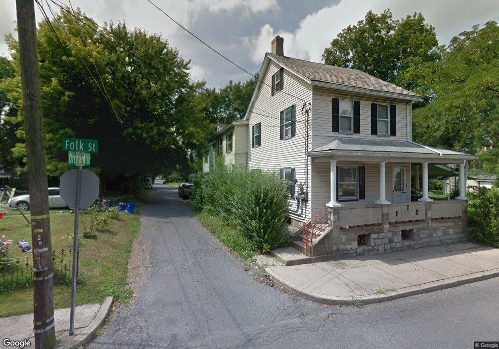
109 Orchard St Easton, PA 18042
Southside Easton NeighborhoodEstimated Value: $164,000 - $239,000
3
Beds
1
Bath
1,478
Sq Ft
$141/Sq Ft
Est. Value
About This Home
This home is located at 109 Orchard St, Easton, PA 18042 and is currently estimated at $208,884, approximately $141 per square foot. 109 Orchard St is a home located in Northampton County with nearby schools including Cheston Elementary School, Easton Area Middle School, and Easton Area High School.
Ownership History
Date
Name
Owned For
Owner Type
Purchase Details
Closed on
Apr 20, 2007
Sold by
Rissmiller Gene
Bought by
Martinez Carlos
Current Estimated Value
Home Financials for this Owner
Home Financials are based on the most recent Mortgage that was taken out on this home.
Original Mortgage
$89,000
Interest Rate
6.24%
Mortgage Type
New Conventional
Purchase Details
Closed on
Nov 1, 1995
Bought by
Rissmiller Gene and Rose Marie
Create a Home Valuation Report for This Property
The Home Valuation Report is an in-depth analysis detailing your home's value as well as a comparison with similar homes in the area
Home Values in the Area
Average Home Value in this Area
Purchase History
| Date | Buyer | Sale Price | Title Company |
|---|---|---|---|
| Martinez Carlos | $89,000 | -- | |
| Rissmiller Gene | -- | -- |
Source: Public Records
Mortgage History
| Date | Status | Borrower | Loan Amount |
|---|---|---|---|
| Previous Owner | Martinez Carlos | $89,000 |
Source: Public Records
Tax History Compared to Growth
Tax History
| Year | Tax Paid | Tax Assessment Tax Assessment Total Assessment is a certain percentage of the fair market value that is determined by local assessors to be the total taxable value of land and additions on the property. | Land | Improvement |
|---|---|---|---|---|
| 2025 | $313 | $29,000 | $12,000 | $17,000 |
| 2024 | $3,008 | $29,000 | $12,000 | $17,000 |
| 2023 | $3,008 | $29,000 | $12,000 | $17,000 |
| 2022 | $2,970 | $29,000 | $12,000 | $17,000 |
| 2021 | $2,962 | $29,000 | $12,000 | $17,000 |
| 2020 | $2,961 | $29,000 | $12,000 | $17,000 |
| 2019 | $2,926 | $29,000 | $12,000 | $17,000 |
| 2018 | $2,884 | $29,000 | $12,000 | $17,000 |
| 2017 | $2,828 | $29,000 | $12,000 | $17,000 |
| 2016 | -- | $29,000 | $12,000 | $17,000 |
| 2015 | -- | $29,000 | $12,000 | $17,000 |
| 2014 | -- | $29,000 | $12,000 | $17,000 |
Source: Public Records
Map
Nearby Homes
- 147 James St
- 133 E Nesquehoning St
- 137 E Nesquehoning St
- 161 W Wilkes Barre St
- 245 W Nesquehoning St
- 249 W Nesquehoning St
- 115 E Wilkes Barre St
- 270 W Wilkes Barre St
- 304 W Canal St
- 354 W Saint Joseph St
- 351 W Wilkes Barre St
- 618 James St
- 622 Folk St
- 425 W Wilkes Barre St
- 230 Ferry St
- 419 W Lincoln St
- 425 W Lincoln St
- 237 Ferry St
- 225 Ferry St
- 820 Philadelphia Rd
- 113 Orchard St
- 219 Folk St
- 114 W Madison St
- 203 Folk St
- 106 W Madison St
- 104 W Madison St
- 235 Folk St
- 120 W Madison St
- 109 W Saint Joseph St
- 111 W Saint Joseph St
- 117 W Saint Joseph St
- 126 W Madison St
- 119 W Saint Joseph St
- 222 Folk St
- 123 W Saint Joseph St
- 204 Folk St
- 226 Folk St
- 208 Folk St
- 220 Folk St
- 237 Folk St