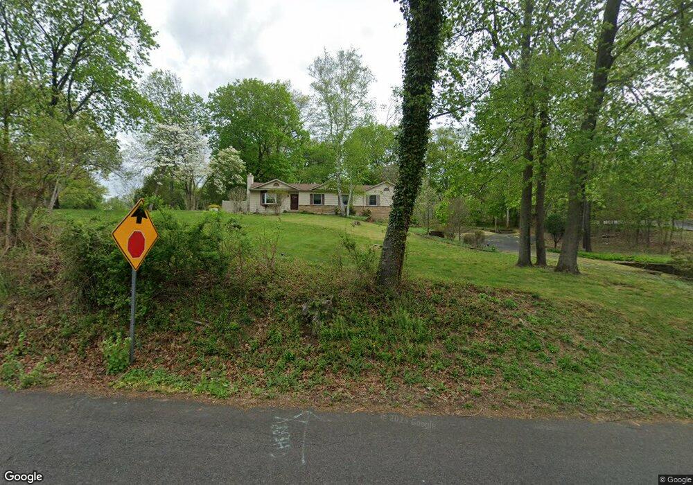
109 Rogers Rd Furlong, PA 18925
Estimated Value: $629,014 - $694,000
3
Beds
2
Baths
2,140
Sq Ft
$310/Sq Ft
Est. Value
About This Home
This home is located at 109 Rogers Rd, Furlong, PA 18925 and is currently estimated at $664,004, approximately $310 per square foot. 109 Rogers Rd is a home located in Bucks County with nearby schools including Kutz Elementary School, Lenape Middle School, and Central Bucks High School-West.
Ownership History
Date
Name
Owned For
Owner Type
Purchase Details
Closed on
Nov 4, 2016
Sold by
Dubois Sandra L and Baldwin Tiffany
Bought by
Dubois Sandra L
Current Estimated Value
Purchase Details
Closed on
Oct 10, 2005
Sold by
Dubois Sandra L and Baldwin Richard H
Bought by
Dubois Sandra L and Living Trust Of Sandra L Dubois
Purchase Details
Closed on
Nov 1, 2001
Sold by
Rauschman Alix and Rauschman Amy
Bought by
Baldwin Richard H and Dubois Sandra L
Home Financials for this Owner
Home Financials are based on the most recent Mortgage that was taken out on this home.
Original Mortgage
$225,600
Outstanding Balance
$87,395
Interest Rate
6.6%
Estimated Equity
$576,609
Purchase Details
Closed on
Jun 19, 1996
Sold by
Mcfadden John J and Mcfadden Gail M
Bought by
Raushman Ardith
Create a Home Valuation Report for This Property
The Home Valuation Report is an in-depth analysis detailing your home's value as well as a comparison with similar homes in the area
Home Values in the Area
Average Home Value in this Area
Purchase History
| Date | Buyer | Sale Price | Title Company |
|---|---|---|---|
| Dubois Sandra L | -- | None Available | |
| Dubois Sandra L | -- | None Available | |
| Baldwin Richard H | $282,000 | -- | |
| Raushman Ardith | $220,000 | T A Title Insurance Company |
Source: Public Records
Mortgage History
| Date | Status | Borrower | Loan Amount |
|---|---|---|---|
| Open | Baldwin Richard H | $225,600 | |
| Closed | Baldwin Richard H | $14,100 |
Source: Public Records
Tax History Compared to Growth
Tax History
| Year | Tax Paid | Tax Assessment Tax Assessment Total Assessment is a certain percentage of the fair market value that is determined by local assessors to be the total taxable value of land and additions on the property. | Land | Improvement |
|---|---|---|---|---|
| 2025 | $6,158 | $34,800 | $9,120 | $25,680 |
| 2024 | $6,158 | $34,800 | $9,120 | $25,680 |
| 2023 | $5,872 | $34,800 | $9,120 | $25,680 |
| 2022 | $5,807 | $34,800 | $9,120 | $25,680 |
| 2021 | $5,687 | $34,800 | $9,120 | $25,680 |
| 2020 | $5,661 | $34,800 | $9,120 | $25,680 |
| 2019 | $5,600 | $34,800 | $9,120 | $25,680 |
| 2018 | $5,583 | $34,800 | $9,120 | $25,680 |
| 2017 | $5,539 | $34,800 | $9,120 | $25,680 |
| 2016 | $5,504 | $34,800 | $9,120 | $25,680 |
| 2015 | -- | $34,800 | $9,120 | $25,680 |
| 2014 | -- | $34,800 | $9,120 | $25,680 |
Source: Public Records
Map
Nearby Homes
- lot #3 next to 3739 York Rd
- 106 Saddle Dr
- 3889 Robin Rd
- 126 Short Rd
- 2294 Staffordshire Rd
- 3772 Powder Horn Dr
- 2479 Wheatfield Ln
- 2209 Swamp Rd
- 3015 Yorkshire Rd
- 3657 Powder Horn Dr
- 152 Watercrest Dr
- 150 Watercrest Dr
- 249 East Rd
- 000 Cherry Ln
- 2443 Sugar Bottom Rd
- 3775 Buckingham Dr
- 223 Cherry Ln
- 3138 E Brighton St Unit 37
- 2080 Bedfordshire Rd
- 2310 S Whittmore St