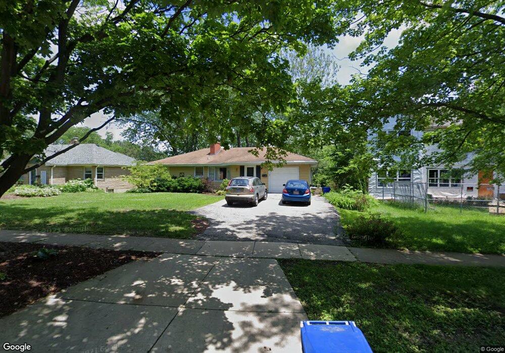
109 S Blanchard St Wheaton, IL 60187
Southeast Wheaton NeighborhoodEstimated Value: $401,456 - $474,000
3
Beds
1
Bath
1,438
Sq Ft
$305/Sq Ft
Est. Value
About This Home
This home is located at 109 S Blanchard St, Wheaton, IL 60187 and is currently estimated at $438,614, approximately $305 per square foot. 109 S Blanchard St is a home located in DuPage County with nearby schools including Lowell Elementary School, Franklin Middle School, and Wheaton North High School.
Ownership History
Date
Name
Owned For
Owner Type
Purchase Details
Closed on
Feb 25, 2020
Sold by
Alston Carl F and Alston Melinda R
Bought by
Alston Carl F and Carl F Alston Revocable Trust
Current Estimated Value
Purchase Details
Closed on
Aug 16, 1995
Sold by
Blumhofer Edwin and Blumhofer Edith L
Bought by
Alston Carl F and Alston Melinda R
Home Financials for this Owner
Home Financials are based on the most recent Mortgage that was taken out on this home.
Original Mortgage
$145,350
Interest Rate
7.55%
Create a Home Valuation Report for This Property
The Home Valuation Report is an in-depth analysis detailing your home's value as well as a comparison with similar homes in the area
Home Values in the Area
Average Home Value in this Area
Purchase History
| Date | Buyer | Sale Price | Title Company |
|---|---|---|---|
| Alston Carl F | -- | Attorney | |
| Alston Carl F | $161,500 | -- |
Source: Public Records
Mortgage History
| Date | Status | Borrower | Loan Amount |
|---|---|---|---|
| Closed | Alston Carl F | $145,350 |
Source: Public Records
Tax History
| Year | Tax Paid | Tax Assessment Tax Assessment Total Assessment is a certain percentage of the fair market value that is determined by local assessors to be the total taxable value of land and additions on the property. | Land | Improvement |
|---|---|---|---|---|
| 2024 | $8,060 | $133,052 | $41,805 | $91,247 |
| 2023 | $7,736 | $122,470 | $38,480 | $83,990 |
| 2022 | $7,600 | $115,740 | $36,360 | $79,380 |
| 2021 | $7,373 | $113,000 | $35,500 | $77,500 |
| 2020 | $7,549 | $111,950 | $35,170 | $76,780 |
| 2019 | $7,373 | $108,990 | $34,240 | $74,750 |
| 2018 | $7,912 | $115,240 | $42,870 | $72,370 |
| 2017 | $7,792 | $110,990 | $41,290 | $69,700 |
| 2016 | $7,686 | $106,560 | $39,640 | $66,920 |
| 2015 | $7,624 | $101,660 | $37,820 | $63,840 |
| 2014 | $6,556 | $86,860 | $26,760 | $60,100 |
| 2013 | $6,388 | $87,120 | $26,840 | $60,280 |
Source: Public Records
Map
Nearby Homes
- 502 S Summit St
- 510 S President St
- 185 N Ott Ave
- 328 Lorraine St
- 1019 Pershing Ave
- 820 Cherry St
- 720 E Harrison Ave
- 421 E Willow Ave
- 404 Lawrence Ave
- 412 Lawrence Ave
- 353 E Liberty Dr
- 230 Duane St Unit 3A
- 1000 S Lorraine Rd Unit 214
- 817 E Forest Ave
- 1216 E Elm St
- 312 E Lincoln Ave
- 388 Hill Ave
- 715 S Naperville Rd
- 607 E Prairie Ave
- 1344 S Lorraine Rd Unit C
- 103 S Blanchard St
- 115 S Blanchard St
- 119 S Blanchard St
- 108 S Blanchard St
- 112 S Blanchard St
- 116 S Blanchard St
- 106 S Blanchard St
- 102 S Blanchard St
- 108 S Summit St
- 201 N Blanchard St
- 120 S Blanchard St
- 127 S Blanchard St
- 114 S Summit St
- 202 N Summit St
- 124 S Blanchard St
- 130 S Blanchard St
- 200 N Blanchard St
- 203 N Blanchard St
- 120 S Summit St
- 107 S Williston St
Your Personal Tour Guide
Ask me questions while you tour the home.