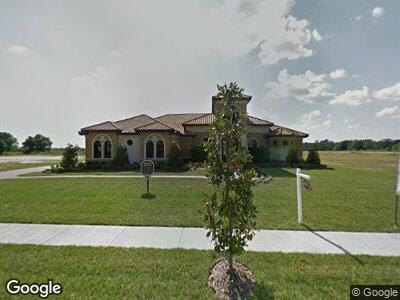
10917 Brooksnest Ct Lithia, FL 33547
Estimated Value: $1,479,000 - $2,245,000
5
Beds
6
Baths
7,265
Sq Ft
$233/Sq Ft
Est. Value
About This Home
This home is located at 10917 Brooksnest Ct, Lithia, FL 33547 and is currently estimated at $1,689,269, approximately $232 per square foot. 10917 Brooksnest Ct is a home located in Hillsborough County with nearby schools including Pinecrest Elementary School, Barrington Middle School, and Newsome High School.
Ownership History
Date
Name
Owned For
Owner Type
Purchase Details
Closed on
Dec 29, 2011
Sold by
J Bartlett Inc
Bought by
Finger Derek A and Finger Jenifer N
Current Estimated Value
Home Financials for this Owner
Home Financials are based on the most recent Mortgage that was taken out on this home.
Original Mortgage
$417,000
Interest Rate
4.06%
Mortgage Type
New Conventional
Purchase Details
Closed on
Aug 20, 2009
Sold by
B & B Ventures Of Lithia Llc
Bought by
J Bartlett Inc
Home Financials for this Owner
Home Financials are based on the most recent Mortgage that was taken out on this home.
Original Mortgage
$690,000
Interest Rate
5.19%
Mortgage Type
Construction
Create a Home Valuation Report for This Property
The Home Valuation Report is an in-depth analysis detailing your home's value as well as a comparison with similar homes in the area
Home Values in the Area
Average Home Value in this Area
Purchase History
| Date | Buyer | Sale Price | Title Company |
|---|---|---|---|
| Finger Derek A | $699,000 | Fidelity Natl Title Fl Inc | |
| J Bartlett Inc | $65,000 | Hillsborough Title Inc |
Source: Public Records
Mortgage History
| Date | Status | Borrower | Loan Amount |
|---|---|---|---|
| Open | Finger Derek A | $705,000 | |
| Closed | Finger Derek A | $417,000 | |
| Closed | Finger Derek A | $211,000 | |
| Previous Owner | J Bartlett Inc | $690,000 |
Source: Public Records
Tax History Compared to Growth
Tax History
| Year | Tax Paid | Tax Assessment Tax Assessment Total Assessment is a certain percentage of the fair market value that is determined by local assessors to be the total taxable value of land and additions on the property. | Land | Improvement |
|---|---|---|---|---|
| 2024 | $10,378 | $605,676 | -- | -- |
| 2023 | $10,061 | $588,035 | $0 | $0 |
| 2022 | $9,734 | $570,908 | $0 | $0 |
| 2021 | $9,645 | $554,280 | $0 | $0 |
| 2020 | $9,515 | $546,627 | $0 | $0 |
| 2019 | $9,330 | $534,337 | $0 | $0 |
| 2018 | $9,223 | $524,374 | $0 | $0 |
| 2017 | $9,121 | $799,683 | $0 | $0 |
| 2016 | $9,075 | $503,025 | $0 | $0 |
| 2015 | $9,182 | $499,528 | $0 | $0 |
| 2014 | $9,150 | $495,563 | $0 | $0 |
| 2013 | -- | $488,239 | $0 | $0 |
Source: Public Records
Map
Nearby Homes
- 323 Hawk Talon Dr
- 304 Hawk Talon Dr
- 11015 S County Road 39
- 201 Copper Penny Ln
- 0 S County Road 39 Unit MFRTB8373535
- 260 Moccasin Hollow Rd
- 10946 Gun Dog Way
- 265 Corbett Rd
- 439 Corbett Rd
- 808 Old Welcome Rd
- 11008 Browning Rd
- 18818 Dorman Rd
- 10101 Bryant Rd
- 10469 Meadowrun Dr
- 10183 Meadowrun Dr
- 14643 Brumby Ridge Ave
- 12650 Shetland Walk Dr
- 12643 Horseshoe Bend Dr
- 10096 Meadowrun Dr
- 1641 Thompson Rd
- 10917 Brooksnest Ct
- 10911 Brooksnest Ct
- 10923 Brooksnest Ct
- 0 Brooksnest Ct
- 309 Hawk Talon Dr
- 317 Hawk Talon Dr
- Brooksnest
- 10916 Brooksnest Ct
- 10922 Brooksnest Ct
- 10910 Brooksnest Ct
- 10906 Brooksnest Ct
- 10928 Brooksnest Ct
- 310 Hawk Talon Dr
- 322 Hawk Talon Dr
- 10915 Brice Tree Ct
- 10909 Brice Tree Ct
- 328 Hawk Talon Dr
- 335 Hawk Talon Dr
- 10927 Brice Tree Ct
- 212 Hawk Talon Dr