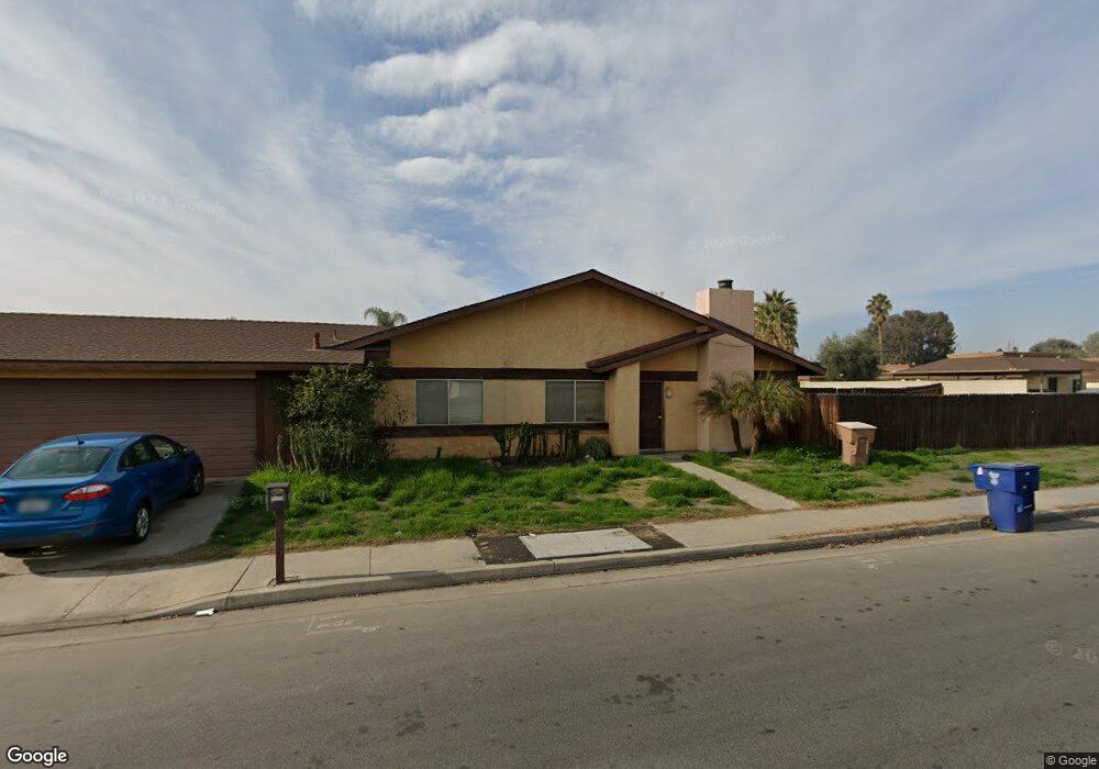
1095 McDonald Way Bakersfield, CA 93309
Southwest Bakersfield NeighborhoodEstimated Value: $156,253 - $290,000
3
Beds
2
Baths
1,203
Sq Ft
$185/Sq Ft
Est. Value
About This Home
This home is located at 1095 McDonald Way, Bakersfield, CA 93309 and is currently estimated at $223,127, approximately $185 per square foot. 1095 McDonald Way is a home located in Kern County with nearby schools including Munsey Elementary School, Curran Middle School, and West High School.
Ownership History
Date
Name
Owned For
Owner Type
Purchase Details
Closed on
Dec 30, 2016
Sold by
Gmb Rental Properties Inc
Bought by
Bk Rental Properties Inc
Current Estimated Value
Purchase Details
Closed on
Aug 25, 2009
Sold by
Gmb Rental Properties Inc
Bought by
Gmb Rental Properties Inc
Purchase Details
Closed on
Jul 30, 2009
Sold by
Lal Moti
Bought by
Gmb Properties Inc
Purchase Details
Closed on
Apr 13, 2009
Sold by
Kumari Sudesh
Bought by
Lal Moti
Home Financials for this Owner
Home Financials are based on the most recent Mortgage that was taken out on this home.
Original Mortgage
$42,750
Interest Rate
4.8%
Mortgage Type
Commercial
Purchase Details
Closed on
Dec 8, 1997
Sold by
Saba Jack
Bought by
Saba Jack and Saba Elizabeth
Create a Home Valuation Report for This Property
The Home Valuation Report is an in-depth analysis detailing your home's value as well as a comparison with similar homes in the area
Home Values in the Area
Average Home Value in this Area
Purchase History
| Date | Buyer | Sale Price | Title Company |
|---|---|---|---|
| Bk Rental Properties Inc | -- | None Available | |
| Gmb Rental Properties Inc | -- | Accommodation | |
| Gmb Properties Inc | -- | Accommodation | |
| Lal Moti | -- | First American Title Company | |
| Lal Moti | $57,000 | First American Title Company | |
| Saba Jack | -- | -- |
Source: Public Records
Mortgage History
| Date | Status | Borrower | Loan Amount |
|---|---|---|---|
| Previous Owner | Lal Moti | $42,750 |
Source: Public Records
Tax History Compared to Growth
Tax History
| Year | Tax Paid | Tax Assessment Tax Assessment Total Assessment is a certain percentage of the fair market value that is determined by local assessors to be the total taxable value of land and additions on the property. | Land | Improvement |
|---|---|---|---|---|
| 2025 | $1,664 | $73,384 | $32,183 | $41,201 |
| 2024 | $1,287 | $71,946 | $31,552 | $40,394 |
| 2023 | $1,287 | $70,536 | $30,934 | $39,602 |
| 2022 | $1,412 | $69,154 | $30,328 | $38,826 |
| 2021 | $1,315 | $67,799 | $29,734 | $38,065 |
| 2020 | $1,280 | $67,105 | $29,430 | $37,675 |
| 2019 | $1,255 | $67,105 | $29,430 | $37,675 |
| 2018 | $1,228 | $64,501 | $28,288 | $36,213 |
| 2017 | $1,218 | $63,237 | $27,734 | $35,503 |
| 2016 | $1,135 | $61,998 | $27,191 | $34,807 |
| 2015 | $1,125 | $61,068 | $26,783 | $34,285 |
| 2014 | $1,089 | $59,873 | $26,259 | $33,614 |
Source: Public Records
Map
Nearby Homes
- 4317 Parkwood Ct
- 4700 Nordic Dr Unit I
- 4801 Belle Terrace Unit C
- 1413 Libra Ct
- 4900 Nordic Dr Unit 6
- 1437 Libra Ct
- 4408 Fishering Dr
- 1455 Gemini Ct
- 613 Middlefield St
- 4117 Erin Ct
- 4428 Belle Terrace
- 613 Fiorito St
- 4016 Granada Ave
- 512 McDonald Way
- 4917 Scorpio Ct
- 4830 Taurus Ct
- 507 McDonald Way
- 3912 Quarter Ave
- 5101 Hunter Ave Unit 2
- 4504 Parkwood Ct
- 4508 Parkwood Ct
- 4512 Parkwood Ct
- 1044 McDonald Way
- 4600 Parkwood Ct
- 1100 McDonald Way
- 1101 McDonald Way
- 4505 Parkwood Ct
- 4509 Parkwood Ct
- 4513 Parkwood Ct
- 4517 Parkwood Ct
- 1108 McDonald Way Unit A-D
- 4608 Parkwood Ct
- 4601 Parkwood Ct
- 4424 Parkwood Ct
- 4605 Parkwood Ct
- 4612 Parkwood Ct
- 4425 Parkwood Ct
- 1201 McDonald Way
- 4504 Norseman St