Estimated Value: $472,000 - $493,942
3
Beds
1
Bath
1,144
Sq Ft
$423/Sq Ft
Est. Value
About This Home
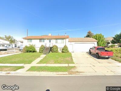
This home is located at 1096 W 1870 N, Lehi, UT 84043 and is currently estimated at $483,486, approximately $422 per square foot. 1096 W 1870 N is a home located in Utah County with nearby schools including Lehi Elementary School, Lehi Junior High School, and Lehi High School.
Ownership History
Date
Name
Owned For
Owner Type
Purchase Details
Closed on
Sep 4, 2008
Sold by
Larson Robert A and Larson Diana P
Bought by
Larson Robert A and Larson Diana P
Current Estimated Value
Purchase Details
Closed on
Feb 23, 2001
Sold by
Oliver Janina Park and Park Robert Dee
Bought by
Larson Robert A and Larson Diana P
Home Financials for this Owner
Home Financials are based on the most recent Mortgage that was taken out on this home.
Original Mortgage
$86,000
Interest Rate
7.11%
Create a Home Valuation Report for This Property
The Home Valuation Report is an in-depth analysis detailing your home's value as well as a comparison with similar homes in the area
Home Values in the Area
Average Home Value in this Area
Purchase History
| Date | Buyer | Sale Price | Title Company |
|---|---|---|---|
| Larson Robert A | -- | None Available | |
| Larson Robert A | -- | Equity Title Agency Inc | |
| Larson Robert A | -- | Equity Title Agency Inc |
Source: Public Records
Mortgage History
| Date | Status | Borrower | Loan Amount |
|---|---|---|---|
| Closed | Larson Robert A | $86,000 |
Source: Public Records
Tax History Compared to Growth
Tax History
| Year | Tax Paid | Tax Assessment Tax Assessment Total Assessment is a certain percentage of the fair market value that is determined by local assessors to be the total taxable value of land and additions on the property. | Land | Improvement |
|---|---|---|---|---|
| 2024 | $1,838 | $215,050 | $0 | $0 |
| 2023 | $1,730 | $219,835 | $0 | $0 |
| 2022 | $1,659 | $204,325 | $0 | $0 |
| 2021 | $1,452 | $270,400 | $106,500 | $163,900 |
| 2020 | $1,368 | $251,800 | $98,600 | $153,200 |
| 2019 | $1,316 | $251,800 | $98,600 | $153,200 |
| 2018 | $1,364 | $246,700 | $93,500 | $153,200 |
| 2017 | $1,294 | $124,465 | $0 | $0 |
| 2016 | $1,327 | $118,415 | $0 | $0 |
| 2015 | $1,254 | $106,205 | $0 | $0 |
| 2014 | $1,144 | $96,360 | $0 | $0 |
Source: Public Records
Map
Nearby Homes
- 1014 W Mountain Way Unit 326
- 996 W Mountain Way Unit 329
- 1235 W 1870 N
- 1011 W Mountain Way Unit 316
- 1708 N Trinnaman Ln
- 1951 N Hollow Ct
- 1693 W Westbury Unit D
- 1817 W Bad Rock Cir Unit 100303
- 1153 W 1425 N
- 935 W 2400 N Unit S
- 2327 N 700 W
- 1331 N 900 W
- 1460 N 1700 W Unit 101
- 1451 W 1220 St N
- 1627 W Boxwood Dr Unit 110
- 1051 N 3685 W Unit 250
- 1027 N 3685 W Unit 248
- 1003 N 3685 W Unit 246
- 1993 N 2090 W
- 2121 W 1960 N
- 1096 W 1870 N
- 1102 W 1870 N
- 1163 W 1900 N
- 1090 W 1870 N
- 1131 W State St
- 1267 W State St
- 1095 W 1870 N
- 1184 W 1870 N
- 1183 W 1900 N
- 1101 W 1870 N
- 1089 W 1870 N
- 1195 W 1870 N
- 1857 N 1100 W
- 1202 W 1870 N
- 1207 W 1900 N
- 1842 N 1200 W
- 1855 N Trinnaman Ln
- 1855 Trinnaman Ln
- 1759 N 1100 W Unit 1
- 1762 N 1100 W Unit 1