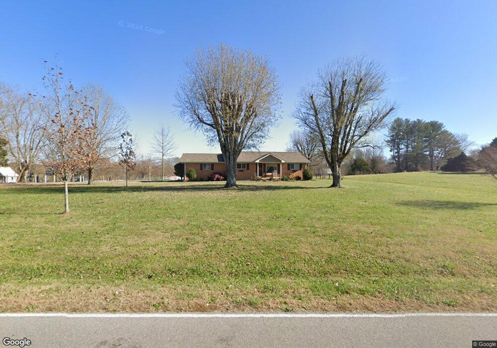
1097 Plunk Whitson Rd Cookeville, TN 38501
Estimated Value: $279,000 - $414,656
--
Bed
2
Baths
1,271
Sq Ft
$265/Sq Ft
Est. Value
About This Home
This home is located at 1097 Plunk Whitson Rd, Cookeville, TN 38501 and is currently estimated at $336,414, approximately $264 per square foot. 1097 Plunk Whitson Rd is a home located in Putnam County with nearby schools including Cane Creek Elementary School, Upperman Middle School, and Upperman High School.
Ownership History
Date
Name
Owned For
Owner Type
Purchase Details
Closed on
Sep 24, 2024
Sold by
Reeder Elizabeth and Reeder Colby
Bought by
Billy David Carter 2021 Revocable Trust and Carter
Current Estimated Value
Purchase Details
Closed on
Jul 15, 2022
Sold by
Reeder and Colby
Bought by
Billy David Carter 2021 Revocable Trust
Purchase Details
Closed on
Dec 22, 2017
Sold by
Carter Billy David
Bought by
Reeder Colby
Home Financials for this Owner
Home Financials are based on the most recent Mortgage that was taken out on this home.
Original Mortgage
$140,000
Interest Rate
3.92%
Mortgage Type
New Conventional
Purchase Details
Closed on
May 11, 2004
Sold by
Tim Releford
Bought by
David Carter Billy and David Joy L
Home Financials for this Owner
Home Financials are based on the most recent Mortgage that was taken out on this home.
Original Mortgage
$82,200
Interest Rate
5.77%
Purchase Details
Closed on
Jul 31, 2000
Sold by
Neill Gordon W
Bought by
Tim Releford and Tim Tracy
Purchase Details
Closed on
Apr 3, 1972
Bought by
Neill Gordon W and Neill Willie G
Create a Home Valuation Report for This Property
The Home Valuation Report is an in-depth analysis detailing your home's value as well as a comparison with similar homes in the area
Home Values in the Area
Average Home Value in this Area
Purchase History
| Date | Buyer | Sale Price | Title Company |
|---|---|---|---|
| Billy David Carter 2021 Revocable Trust | -- | None Listed On Document | |
| Billy David Carter 2021 Revocable Trust | $430,000 | None Listed On Document | |
| Reeder Colby | $160,000 | -- | |
| David Carter Billy | $81,100 | -- | |
| Tim Releford | $88,000 | -- | |
| Neill Gordon W | -- | -- |
Source: Public Records
Mortgage History
| Date | Status | Borrower | Loan Amount |
|---|---|---|---|
| Previous Owner | Reeder Colby | $140,000 | |
| Previous Owner | Neill Gordon W | $82,200 |
Source: Public Records
Tax History Compared to Growth
Tax History
| Year | Tax Paid | Tax Assessment Tax Assessment Total Assessment is a certain percentage of the fair market value that is determined by local assessors to be the total taxable value of land and additions on the property. | Land | Improvement |
|---|---|---|---|---|
| 2024 | $1,005 | $37,800 | $7,050 | $30,750 |
| 2023 | $1,005 | $37,800 | $7,050 | $30,750 |
| 2022 | $934 | $37,800 | $7,050 | $30,750 |
| 2021 | $934 | $37,800 | $7,050 | $30,750 |
| 2020 | $816 | $37,800 | $7,050 | $30,750 |
| 2019 | $702 | $27,900 | $7,050 | $20,850 |
| 2018 | $655 | $24,000 | $7,050 | $16,950 |
| 2017 | $655 | $24,000 | $7,050 | $16,950 |
| 2016 | $655 | $24,000 | $7,050 | $16,950 |
| 2015 | $673 | $24,000 | $7,050 | $16,950 |
| 2014 | $648 | $23,090 | $0 | $0 |
Source: Public Records
Map
Nearby Homes
- 1065 Plunk Whitson Rd
- 1117 Plunk Whitson Rd
- 1104 Plunk Whitson Rd
- 00 Plunk Whitson Rd
- 1140 Sunny Dr
- 1136 Plunk Whitson Rd
- 1101 Sunny Dr
- 1064 Sunny Dr
- 1182 Plunk Whitson Rd
- 3829 Shady Oak Cir
- 3823 Shady Oak Cir
- 3835 Shady Oak Cir
- 1054 Plunk Whitson Rd
- 3817 Shady Oak Cir
- 1031 Sunny Dr
- 1.4 AC Shady Oak Cir
- Lot #18 Shady Oak Cir
- Lots 18- Shady Oak Cir
- 993 Plunk Whitson Rd
- 1241 Plunk Whitson Rd