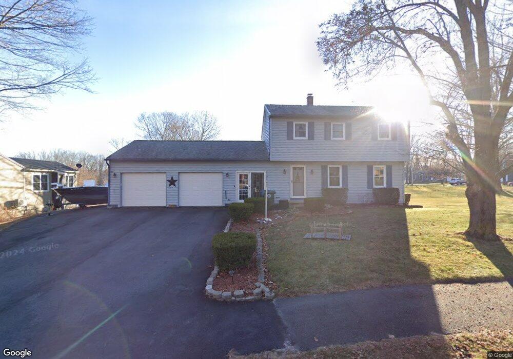
11 Alberta Dr Westbrook, ME 04092
Estimated Value: $499,457 - $555,000
3
Beds
2
Baths
1,496
Sq Ft
$353/Sq Ft
Est. Value
About This Home
This home is located at 11 Alberta Dr, Westbrook, ME 04092 and is currently estimated at $527,614, approximately $352 per square foot. 11 Alberta Dr is a home located in Cumberland County with nearby schools including Westbrook High School, Breakwater School, and St. Brigid School.
Ownership History
Date
Name
Owned For
Owner Type
Purchase Details
Closed on
Aug 29, 2006
Sold by
Caron Wayne R and Caron Ruth
Bought by
Stoddard Ray F and Schildroth Heidi L
Current Estimated Value
Home Financials for this Owner
Home Financials are based on the most recent Mortgage that was taken out on this home.
Original Mortgage
$279,000
Outstanding Balance
$167,276
Interest Rate
6.83%
Mortgage Type
Purchase Money Mortgage
Estimated Equity
$360,338
Create a Home Valuation Report for This Property
The Home Valuation Report is an in-depth analysis detailing your home's value as well as a comparison with similar homes in the area
Home Values in the Area
Average Home Value in this Area
Purchase History
| Date | Buyer | Sale Price | Title Company |
|---|---|---|---|
| Stoddard Ray F | -- | -- |
Source: Public Records
Mortgage History
| Date | Status | Borrower | Loan Amount |
|---|---|---|---|
| Open | Stoddard Ray F | $279,000 |
Source: Public Records
Tax History
| Year | Tax Paid | Tax Assessment Tax Assessment Total Assessment is a certain percentage of the fair market value that is determined by local assessors to be the total taxable value of land and additions on the property. | Land | Improvement |
|---|---|---|---|---|
| 2023 | $5,144 | $308,400 | $89,500 | $218,900 |
| 2022 | $4,664 | $257,700 | $74,500 | $183,200 |
| 2021 | $4,595 | $257,700 | $74,500 | $183,200 |
| 2020 | $4,603 | $257,700 | $74,500 | $183,200 |
| 2019 | $4,603 | $257,700 | $74,500 | $183,200 |
| 2018 | $4,441 | $222,600 | $64,700 | $157,900 |
| 2017 | $4,203 | $222,600 | $64,700 | $157,900 |
| 2016 | $4,096 | $222,600 | $64,700 | $157,900 |
| 2015 | $3,998 | $222,600 | $64,700 | $157,900 |
| 2014 | $3,829 | $222,600 | $64,700 | $157,900 |
| 2013 | $3,829 | $222,600 | $64,700 | $157,900 |
Source: Public Records
Map
Nearby Homes
- 30 Fawn Woods Way Unit 30
- 7 Apex Dr Unit 2
- 5 Apex Dr Unit 1
- 3 Collins Place Unit 5
- 7 Collins Place Unit 6
- 22 Collins Place Dr Unit 4
- 272 Cumberland St
- 7 Kasseys Way Unit 5
- 10 Everett Ct
- 18 Summit Cir
- 132 North St
- 78 North St
- 383 Main St
- 25 Cole St Unit 2
- 26 King St Unit 1
- 18 Cole St
- 32 Kennard St
- 26 Stillwater Dr Unit 26
- 10 Hogan Cir Unit 35
- 50 Hogan Cir Unit 2
- Lot 4 Grayce's Way
- Lot 5 Grayce's Way
- TBD Melody Ln
- 536 Riverside St
- Lot 32 Clearwater Unit 32
- Lot 30 Clearwater Dr Unit 30
- Lot 29 Clearwater Dr Unit 29
- Lot 28 Clearwater Dr Unit 28
- Lot 33 Clearwater Dr
- Lot 22 Presumpscot Estates Unit 22
- Lot 34 Presumpscot Estates
- Lot 34 Presumpscot Estates Unit 34
- Lot 30 Clearwater Dr
- Lot 29 Clearwater Dr
- Lot 28 Clearwater Dr
- 44 Chesnut St
- 31 Spiller Dr
- 58 Lugrin Street Extension
- 19 Alberta Dr
- 14 Alberta Dr
Your Personal Tour Guide
Ask me questions while you tour the home.