Estimated Value: $667,000 - $959,000
3
Beds
2
Baths
1,132
Sq Ft
$701/Sq Ft
Est. Value
About This Home
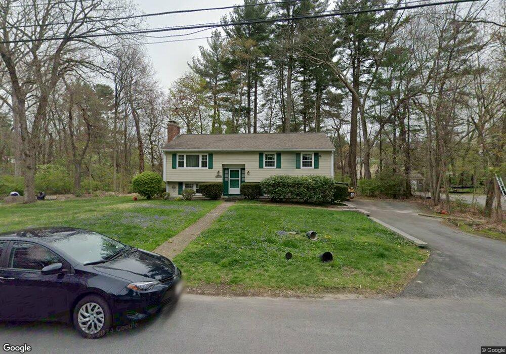
This home is located at 11 Algonquin Rd, Acton, MA 01720 and is currently estimated at $794,027, approximately $701 per square foot. 11 Algonquin Rd is a home located in Middlesex County with nearby schools including Acton-Boxborough Regional High School and Oak Meadow Montessori School.
Ownership History
Date
Name
Owned For
Owner Type
Purchase Details
Closed on
Dec 15, 2000
Sold by
Jones Kurt L and Jones Sonja C
Bought by
Madala Sudhakar R and Madala Rajyalakshmi
Current Estimated Value
Purchase Details
Closed on
Mar 31, 1997
Sold by
Allred William B and Allred Karen A
Bought by
Jones Kurt L and Jones Sonja C
Purchase Details
Closed on
May 24, 1996
Sold by
Wachter Stuart and Wachter Susan R
Bought by
Allard William B and Allard Karen A
Purchase Details
Closed on
Jun 16, 1988
Sold by
Rosenbaum Robert H
Bought by
Wachter Stuart
Create a Home Valuation Report for This Property
The Home Valuation Report is an in-depth analysis detailing your home's value as well as a comparison with similar homes in the area
Home Values in the Area
Average Home Value in this Area
Purchase History
| Date | Buyer | Sale Price | Title Company |
|---|---|---|---|
| Madala Sudhakar R | $350,000 | -- | |
| Jones Kurt L | $239,000 | -- | |
| Allard William B | $236,000 | -- | |
| Wachter Stuart | $219,000 | -- |
Source: Public Records
Mortgage History
| Date | Status | Borrower | Loan Amount |
|---|---|---|---|
| Open | Wachter Stuart | $230,000 |
Source: Public Records
Tax History
| Year | Tax Paid | Tax Assessment Tax Assessment Total Assessment is a certain percentage of the fair market value that is determined by local assessors to be the total taxable value of land and additions on the property. | Land | Improvement |
|---|---|---|---|---|
| 2025 | $10,995 | $641,100 | $315,800 | $325,300 |
| 2024 | $10,420 | $625,100 | $315,800 | $309,300 |
| 2023 | $10,218 | $581,900 | $287,000 | $294,900 |
| 2022 | $9,904 | $509,200 | $249,500 | $259,700 |
| 2021 | $9,308 | $460,100 | $230,800 | $229,300 |
| 2020 | $8,981 | $466,800 | $230,800 | $236,000 |
| 2019 | $8,391 | $433,200 | $230,800 | $202,400 |
| 2018 | $7,969 | $411,200 | $230,800 | $180,400 |
| 2017 | $7,687 | $403,300 | $230,800 | $172,500 |
| 2016 | $7,484 | $389,200 | $230,800 | $158,400 |
| 2015 | $7,349 | $385,800 | $230,800 | $155,000 |
| 2014 | $7,193 | $369,800 | $230,800 | $139,000 |
Source: Public Records
Map
Nearby Homes
- 8 Algonquin Rd
- 60 Nashoba Rd
- 4 Littlefield Rd
- 5 Perkins Ln
- 79 Charter Rd
- 20 Joseph Reed Ln
- 235 Arlington St
- 285 Central St Unit 285
- 4 Omega Way
- 18 Hayward Rd
- 11 Braebrook
- 246 Main St Unit 2
- 33 Meadowbrook Rd
- 7 Kelley Rd
- 92 Willow St Unit 3
- 92 Willow St Unit 2
- 90 Willow St Unit 1
- 46 Taylor Rd
- 305 Harwood Ave
- 491 Main St
Your Personal Tour Guide
Ask me questions while you tour the home.