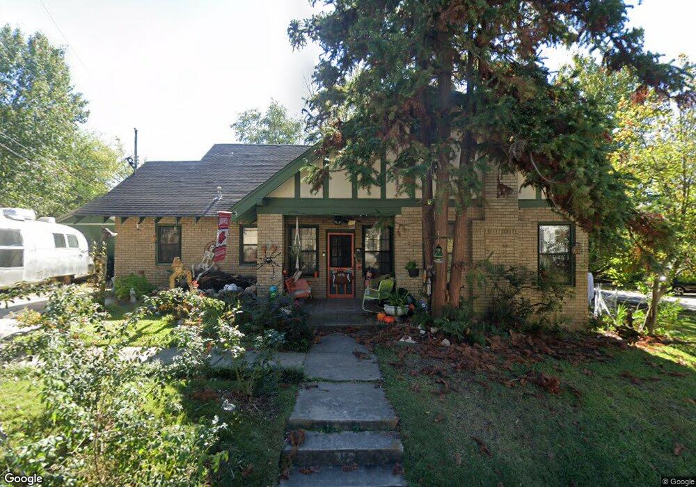
11 Alpine Ct Little Rock, AR 72205
Hillcrest NeighborhoodEstimated Value: $216,000 - $323,000
--
Bed
1
Bath
1,351
Sq Ft
$207/Sq Ft
Est. Value
About This Home
This home is located at 11 Alpine Ct, Little Rock, AR 72205 and is currently estimated at $279,085, approximately $206 per square foot. 11 Alpine Ct is a home located in Pulaski County with nearby schools including Pulaski Heights Elementary School, Pulaski Heights Middle School, and Central High School.
Ownership History
Date
Name
Owned For
Owner Type
Purchase Details
Closed on
Dec 23, 1997
Sold by
Smith Roger W and Smith Monika Garner
Bought by
Smith Roger W and Smith Monika Garner
Current Estimated Value
Purchase Details
Closed on
Jul 3, 1997
Sold by
Goodwin Leslie Louise Finch and Goodwin Derrome
Bought by
Smith Roger W
Home Financials for this Owner
Home Financials are based on the most recent Mortgage that was taken out on this home.
Original Mortgage
$85,000
Interest Rate
8.25%
Mortgage Type
VA
Create a Home Valuation Report for This Property
The Home Valuation Report is an in-depth analysis detailing your home's value as well as a comparison with similar homes in the area
Home Values in the Area
Average Home Value in this Area
Purchase History
| Date | Buyer | Sale Price | Title Company |
|---|---|---|---|
| Smith Roger W | -- | First Security Title Company | |
| Smith Roger W | $85,000 | American Abstract & Title Co |
Source: Public Records
Mortgage History
| Date | Status | Borrower | Loan Amount |
|---|---|---|---|
| Previous Owner | Smith Roger W | $85,000 |
Source: Public Records
Tax History Compared to Growth
Tax History
| Year | Tax Paid | Tax Assessment Tax Assessment Total Assessment is a certain percentage of the fair market value that is determined by local assessors to be the total taxable value of land and additions on the property. | Land | Improvement |
|---|---|---|---|---|
| 2025 | $2,904 | $47,470 | $25,000 | $22,470 |
| 2024 | $2,661 | $47,470 | $25,000 | $22,470 |
| 2023 | $2,661 | $47,470 | $25,000 | $22,470 |
| 2022 | $2,540 | $47,470 | $25,000 | $22,470 |
| 2021 | $2,436 | $34,560 | $16,000 | $18,560 |
| 2020 | $2,044 | $34,560 | $16,000 | $18,560 |
| 2019 | $2,044 | $34,560 | $16,000 | $18,560 |
| 2018 | $1,991 | $34,560 | $16,000 | $18,560 |
| 2017 | $1,884 | $34,560 | $16,000 | $18,560 |
| 2016 | $2,128 | $30,400 | $5,600 | $24,800 |
| 2015 | $2,131 | $30,400 | $5,600 | $24,800 |
| 2014 | $2,131 | $30,400 | $5,600 | $24,800 |
Source: Public Records
Map
Nearby Homes
- 206 Linwood Ct
- 220 S Valentine St
- 312 Valmar St
- 118 N Pine St
- 102 Midland St
- 203 Midland St
- 310 S Oak St
- 1109 Kavanaugh Blvd
- 110 N Cedar St
- 516 N Oak St
- 518 N Oak St
- 1116 Kavanaugh Blvd
- 3409 Hill Rd
- 1204 Kavanaugh Blvd
- 121 N Woodrow St
- 507 Uams Blvd
- 520 S Oak St
- 301 N Woodrow St
- 400 S Booker St
- 605 S Oak St