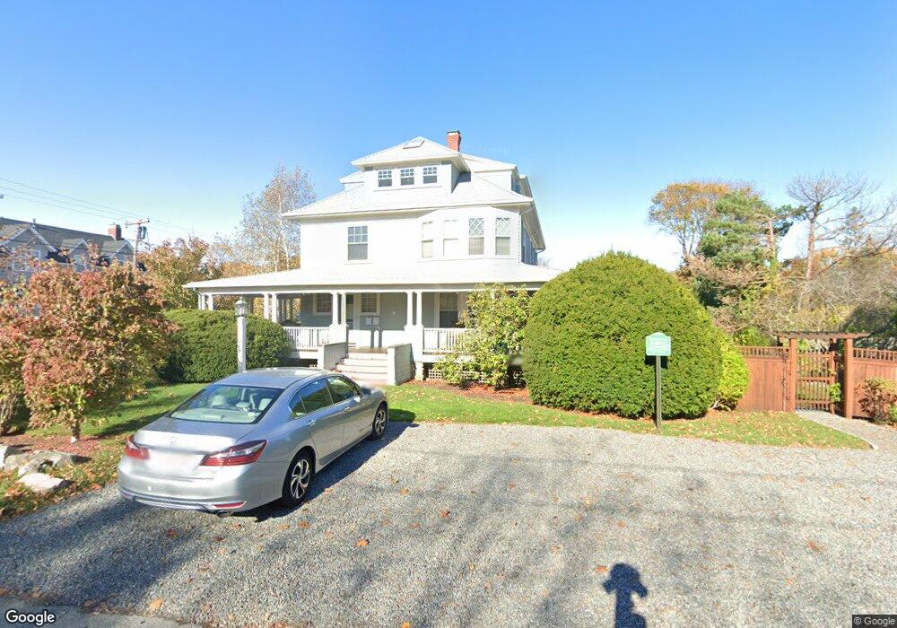
11 Beach Rd Gloucester, MA 01930
East Gloucester NeighborhoodEstimated Value: $831,000 - $1,697,281
6
Beds
6
Baths
3,763
Sq Ft
$338/Sq Ft
Est. Value
About This Home
This home is located at 11 Beach Rd, Gloucester, MA 01930 and is currently estimated at $1,273,094, approximately $338 per square foot. 11 Beach Rd is a home located in Essex County with nearby schools including East Gloucester Elementary School, Ralph B O'maley Middle School, and Gloucester High School.
Ownership History
Date
Name
Owned For
Owner Type
Purchase Details
Closed on
Dec 17, 2021
Sold by
Brecker Sheryl M and London Suzanne L
Bought by
London Brecker T
Current Estimated Value
Purchase Details
Closed on
Sep 21, 2000
Sold by
Whitemore Theresa F
Bought by
Brecker-Fellemn Sheryl and London-Ross Suzanne
Purchase Details
Closed on
Aug 13, 1993
Sold by
Fhlmc
Bought by
Whitmeore Theresa F
Purchase Details
Closed on
Jun 8, 1993
Sold by
Cluett John H
Bought by
Fhlmc
Purchase Details
Closed on
Jan 27, 1993
Sold by
Cluett John H
Bought by
Fhlmc
Purchase Details
Closed on
May 27, 1988
Sold by
Carreiro Nicholas O
Bought by
Cluett John H
Create a Home Valuation Report for This Property
The Home Valuation Report is an in-depth analysis detailing your home's value as well as a comparison with similar homes in the area
Home Values in the Area
Average Home Value in this Area
Purchase History
| Date | Buyer | Sale Price | Title Company |
|---|---|---|---|
| London Brecker T | -- | None Available | |
| Brecker-Fellemn Sheryl | $560,000 | -- | |
| Whitmeore Theresa F | $216,300 | -- | |
| Fhlmc | $289,438 | -- | |
| Fhlmc | $273,992 | -- | |
| Cluett John H | $425,000 | -- |
Source: Public Records
Mortgage History
| Date | Status | Borrower | Loan Amount |
|---|---|---|---|
| Previous Owner | Cluett John H | $168,000 | |
| Previous Owner | Cluett John H | $180,000 |
Source: Public Records
Tax History
| Year | Tax Paid | Tax Assessment Tax Assessment Total Assessment is a certain percentage of the fair market value that is determined by local assessors to be the total taxable value of land and additions on the property. | Land | Improvement |
|---|---|---|---|---|
| 2025 | $14,927 | $1,535,700 | $638,200 | $897,500 |
| 2024 | $12,786 | $1,314,100 | $482,100 | $832,000 |
| 2023 | $12,939 | $1,221,800 | $411,600 | $810,200 |
| 2022 | $11,866 | $1,011,600 | $357,900 | $653,700 |
| 2021 | $11,501 | $924,500 | $325,400 | $599,100 |
| 2020 | $10,996 | $891,800 | $325,400 | $566,400 |
| 2019 | $10,246 | $807,400 | $310,200 | $497,200 |
| 2018 | $9,873 | $763,600 | $302,700 | $460,900 |
| 2017 | $9,543 | $723,500 | $288,100 | $435,400 |
| 2016 | $8,885 | $652,800 | $275,600 | $377,200 |
| 2015 | $8,676 | $635,600 | $269,400 | $366,200 |
Source: Public Records
Map
Nearby Homes
- 70 Bass Ave
- 26 Marina Dr
- 3 Mondello Square
- 11 Wall St Unit R
- 36 Eastern Ave
- 78 Thatcher Rd Unit 6
- 25 Salt Island Rd
- 32 Witham St Unit B
- 197 E Main St Unit 1
- 21 Marble Rd
- 14R Spring St Unit 3
- 23 Mount Vernon St
- 60 Rocky Neck Ave Unit 202
- 10 Seaview Rd
- 73 Rocky Neck Ave Unit 2
- 50 Warner St
- 191 Main St Unit 3
- 191 Main St Unit 2A
- 1 Wonson St
- 113 Pleasant St
- 9 Beach Rd
- 8 Atlantic Rd
- 14 Atlantic Rd Unit 5
- 14 Atlantic Rd Unit 4
- 14 Atlantic Rd Unit 3
- 14 Atlantic Rd Unit 2
- 14 Atlantic Rd Unit 1
- 14 Atlantic Rd
- 14 Atlantic Rd Unit 5
- 9 Atlantic Rd
- 9 Atlantic Rd Unit 2
- 7 Beach Rd
- 12 Beach Rd
- 6 Atlantic Rd
- 8 Beach Rd
- 19 Atlantic Road-Winter Unit 10
- 15 Beach Rd
- 1 Mallard Way
- 5 Beach Rd
- 19 Atlantic Rd Unit 19
Your Personal Tour Guide
Ask me questions while you tour the home.