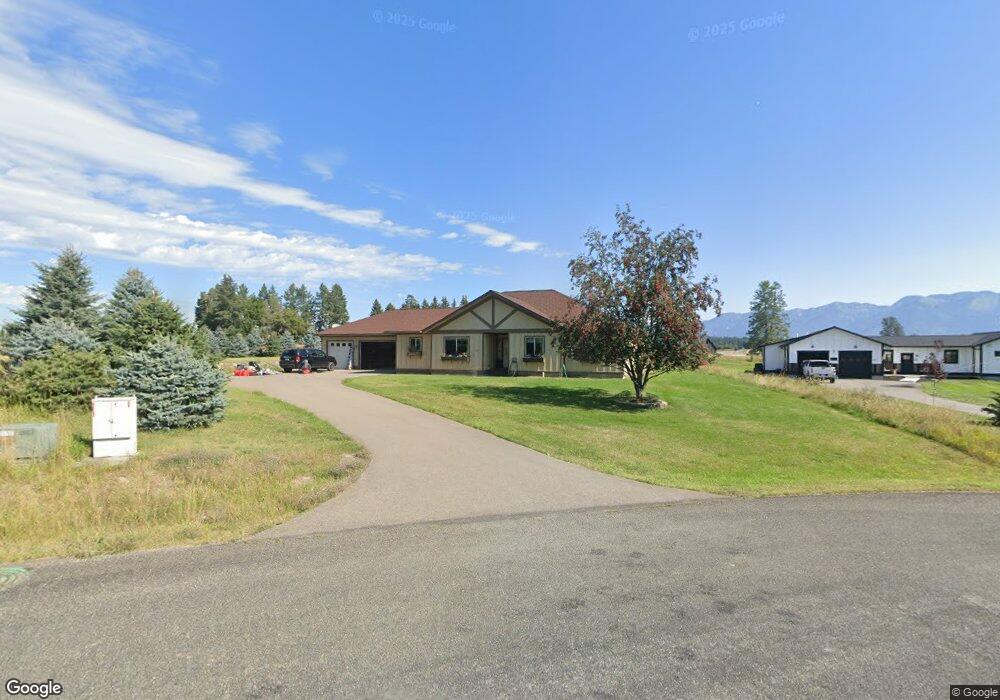
11 Bearpaw Loop Bigfork, MT 59911
Estimated Value: $746,630 - $880,000
3
Beds
2
Baths
1,900
Sq Ft
$425/Sq Ft
Est. Value
About This Home
This home is located at 11 Bearpaw Loop, Bigfork, MT 59911 and is currently estimated at $807,908, approximately $425 per square foot. 11 Bearpaw Loop is a home located in Flathead County with nearby schools including Bigfork Elementary School, Bigfork Middle School, and Bigfork High School.
Ownership History
Date
Name
Owned For
Owner Type
Purchase Details
Closed on
May 12, 2010
Sold by
Littrell Rebecca and Linnell Rebecca
Bought by
Littrell Rebecca
Current Estimated Value
Home Financials for this Owner
Home Financials are based on the most recent Mortgage that was taken out on this home.
Original Mortgage
$170,000
Outstanding Balance
$113,888
Interest Rate
5.04%
Mortgage Type
New Conventional
Estimated Equity
$694,020
Purchase Details
Closed on
Jan 13, 2010
Sold by
Bear Hollow Properties Llc
Bought by
Linnell Rebecca
Create a Home Valuation Report for This Property
The Home Valuation Report is an in-depth analysis detailing your home's value as well as a comparison with similar homes in the area
Home Values in the Area
Average Home Value in this Area
Purchase History
| Date | Buyer | Sale Price | Title Company |
|---|---|---|---|
| Littrell Rebecca | -- | Alliance Title | |
| Linnell Rebecca | -- | First American Title Company |
Source: Public Records
Mortgage History
| Date | Status | Borrower | Loan Amount |
|---|---|---|---|
| Open | Littrell Rebecca | $170,000 |
Source: Public Records
Tax History
| Year | Tax Paid | Tax Assessment Tax Assessment Total Assessment is a certain percentage of the fair market value that is determined by local assessors to be the total taxable value of land and additions on the property. | Land | Improvement |
|---|---|---|---|---|
| 2025 | $2,929 | $771,000 | $0 | $0 |
| 2024 | $2,980 | $534,000 | $0 | $0 |
| 2023 | $3,450 | $534,000 | $0 | $0 |
| 2022 | $3,296 | $362,100 | $0 | $0 |
| 2021 | $2,847 | $362,100 | $0 | $0 |
| 2020 | $3,004 | $314,500 | $0 | $0 |
| 2019 | $2,914 | $314,500 | $0 | $0 |
| 2018 | $2,736 | $276,900 | $0 | $0 |
| 2017 | $2,691 | $276,900 | $0 | $0 |
| 2016 | $2,245 | $221,100 | $0 | $0 |
| 2015 | $2,056 | $221,100 | $0 | $0 |
| 2014 | $2,309 | $153,848 | $0 | $0 |
Source: Public Records
Map
Nearby Homes
- 29 Bearpaw Loop
- 344 Chapman Ln
- 351 Chapman Ln
- 394 Windsor Ct
- 7945 Mt Highway 35
- 32 Peaceful Ct
- 107 Whitetail Ct
- 324 Lake Hills Dr
- 220 Bridger Dr
- 486 Hogue Dr
- 200 Sportsman Ln
- 87 Rock Ridge Way
- 116 Golden Bear Dr
- 260 Crestview Dr
- 112 Golden Bear Dr
- 106 Golden Bear Dr
- 615 Swan Hill Dr
- 175 Aerie Place
- 181 Fox Run Ct
- 161 Fox Run Ct
- 21 Bearpaw Loop Unit Bear Hollow
- 7658 Mt Highway 35
- 7658 Montana Highway 35
- 41 Bearpaw Loop
- 7645 Mt-35
- 7645 Mt Highway 35
- 53 Bearpaw Loop Unit Bear Hollow
- 53 Bearpaw Loop
- 61 Bearpaw Loop
- 0 Bear Paw Loop Unit 308941
- 73 Bearpaw Loop
- 0 Grizzly Ct Unit 308945
- 7664 Mt Highway 35
- 49 Grizzly Ct
- 34 Grizzly Ct
- 81 Bearpaw Loop
- 12 Grizzly Ct
- 1070 Silvertip Dr N
- 1020 Silvertip Dr N
- 1020 Silver Tip N
Your Personal Tour Guide
Ask me questions while you tour the home.