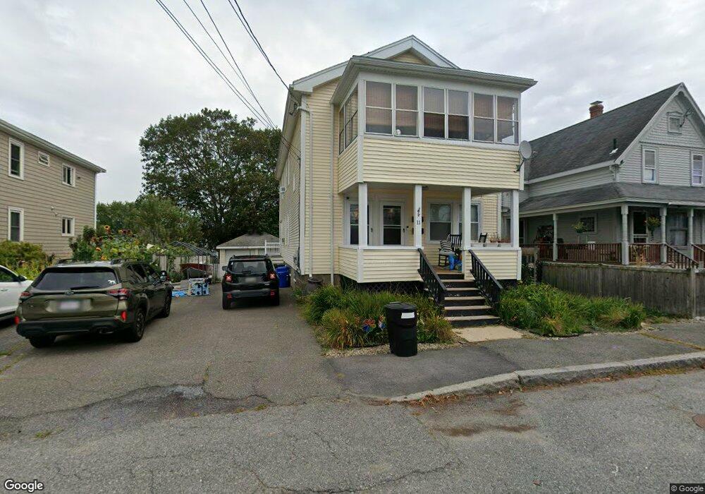
11 Beauport Ave Gloucester, MA 01930
Central Gloucester NeighborhoodEstimated Value: $518,000 - $716,000
4
Beds
2
Baths
2,304
Sq Ft
$282/Sq Ft
Est. Value
About This Home
This home is located at 11 Beauport Ave, Gloucester, MA 01930 and is currently estimated at $650,695, approximately $282 per square foot. 11 Beauport Ave is a home located in Essex County with nearby schools including Plum Cove School, Ralph B O'maley Middle School, and Gloucester High School.
Ownership History
Date
Name
Owned For
Owner Type
Purchase Details
Closed on
Feb 10, 2021
Sold by
Lane Mercedes T
Bought by
Lane Mercedes T and Sutera Marc A
Current Estimated Value
Home Financials for this Owner
Home Financials are based on the most recent Mortgage that was taken out on this home.
Original Mortgage
$343,000
Outstanding Balance
$305,372
Interest Rate
2.7%
Mortgage Type
New Conventional
Estimated Equity
$345,323
Purchase Details
Closed on
Jun 21, 2018
Sold by
Mcnally John R and Mcnally Patricia J
Bought by
Lane Mercedes T
Home Financials for this Owner
Home Financials are based on the most recent Mortgage that was taken out on this home.
Original Mortgage
$300,000
Interest Rate
4%
Mortgage Type
New Conventional
Create a Home Valuation Report for This Property
The Home Valuation Report is an in-depth analysis detailing your home's value as well as a comparison with similar homes in the area
Home Values in the Area
Average Home Value in this Area
Purchase History
| Date | Buyer | Sale Price | Title Company |
|---|---|---|---|
| Lane Mercedes T | -- | None Available | |
| Lane Mercedes T | $400,000 | -- | |
| Lane Mercedes T | $400,000 | -- |
Source: Public Records
Mortgage History
| Date | Status | Borrower | Loan Amount |
|---|---|---|---|
| Open | Lane Mercedes T | $343,000 | |
| Previous Owner | Lane Mercedes T | $300,000 |
Source: Public Records
Tax History Compared to Growth
Tax History
| Year | Tax Paid | Tax Assessment Tax Assessment Total Assessment is a certain percentage of the fair market value that is determined by local assessors to be the total taxable value of land and additions on the property. | Land | Improvement |
|---|---|---|---|---|
| 2025 | $6,073 | $624,800 | $150,200 | $474,600 |
| 2024 | $5,966 | $613,200 | $143,000 | $470,200 |
| 2023 | $6,172 | $582,800 | $127,700 | $455,100 |
| 2022 | $5,805 | $494,900 | $111,100 | $383,800 |
| 2021 | $5,627 | $452,300 | $101,000 | $351,300 |
| 2020 | $5,338 | $432,900 | $101,000 | $331,900 |
| 2019 | $4,972 | $391,800 | $101,000 | $290,800 |
| 2018 | $4,646 | $359,300 | $101,000 | $258,300 |
| 2017 | $4,448 | $337,200 | $96,200 | $241,000 |
| 2016 | $4,340 | $318,900 | $100,300 | $218,600 |
| 2015 | $4,264 | $312,400 | $100,300 | $212,100 |
Source: Public Records
Map
Nearby Homes
- 196 Washington St
- 65 Poplar St
- 19 Mystic Ave
- 15 Harvard St
- 78 Grove St
- 16 Cleveland Place Unit 11
- 18 Cherry St
- 8 Summer St Unit 103
- 33 Maplewood Ave Unit 21
- 40 Sargent St
- 119 Pleasant St
- 5 Washington Square
- 35 Middle St Unit 4
- 33 Middle St
- 90 Middle St Unit L
- 4 Mount Vernon St
- 191 Main St Unit 2B
- 191 Main St Unit 3
- 191 Main St Unit 2A
- 22 Taylor St Unit 1
- 11 Beauport Ave Unit 1
- 7 Beauport Ave
- 13 Beauport Ave
- 8 Madison Ct
- 15 Beauport Ave
- 12 Madison Ct
- 3 Beauport Ave
- 6 Madison Ct Unit 2
- 6 Madison Ct Unit 1
- 10 Beauport Ave
- 14 Madison Ct
- 215 Washington St
- 1 Beauport Ave
- 19 Beauport Ave
- 12 Madison Ave
- 12 Madison Ave Unit 1
- 4 Beauport Ave
- 14 Madison Ave
- 33 Gloucester Ave
- 4 Madison Ave