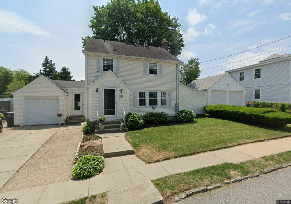
11 Brewster Rd Cranston, RI 02910
Eden Park NeighborhoodEstimated Value: $417,546 - $469,000
3
Beds
2
Baths
1,386
Sq Ft
$329/Sq Ft
Est. Value
About This Home
This home is located at 11 Brewster Rd, Cranston, RI 02910 and is currently estimated at $455,637, approximately $328 per square foot. 11 Brewster Rd is a home located in Providence County with nearby schools including Park View Middle School, Cranston High School East, and Cadence Academy Preschool - Cranston.
Ownership History
Date
Name
Owned For
Owner Type
Purchase Details
Closed on
Oct 15, 2025
Sold by
Vitale Anthony J and Vitale Sharon A
Bought by
Vitale Family Irt and Jorrin
Current Estimated Value
Purchase Details
Closed on
May 15, 1990
Sold by
Moretti Cheryl L
Bought by
Vitale Anthony J
Create a Home Valuation Report for This Property
The Home Valuation Report is an in-depth analysis detailing your home's value as well as a comparison with similar homes in the area
Home Values in the Area
Average Home Value in this Area
Purchase History
| Date | Buyer | Sale Price | Title Company |
|---|---|---|---|
| Vitale Family Irt | -- | -- | |
| Vitale Anthony J | $122,000 | -- |
Source: Public Records
Mortgage History
| Date | Status | Borrower | Loan Amount |
|---|---|---|---|
| Previous Owner | Vitale Anthony J | $150,000 | |
| Previous Owner | Vitale Anthony J | $150,000 | |
| Previous Owner | Vitale Anthony J | $82,600 | |
| Previous Owner | Vitale Anthony J | $90,000 |
Source: Public Records
Tax History
| Year | Tax Paid | Tax Assessment Tax Assessment Total Assessment is a certain percentage of the fair market value that is determined by local assessors to be the total taxable value of land and additions on the property. | Land | Improvement |
|---|---|---|---|---|
| 2025 | $5,032 | $362,500 | $107,100 | $255,400 |
| 2024 | $4,934 | $362,500 | $107,100 | $255,400 |
| 2023 | $4,734 | $250,500 | $70,500 | $180,000 |
| 2022 | $4,637 | $250,500 | $70,500 | $180,000 |
| 2021 | $4,509 | $250,500 | $70,500 | $180,000 |
| 2020 | $4,389 | $211,300 | $67,100 | $144,200 |
| 2019 | $4,389 | $211,300 | $67,100 | $144,200 |
| 2018 | $4,287 | $211,300 | $67,100 | $144,200 |
| 2017 | $4,437 | $193,400 | $60,400 | $133,000 |
| 2016 | $4,342 | $193,400 | $60,400 | $133,000 |
| 2015 | $4,342 | $193,400 | $60,400 | $133,000 |
| 2014 | $4,145 | $181,500 | $60,400 | $121,100 |
Source: Public Records
Map
Nearby Homes
- 33 Hemlock Ave
- 10 Dale Ave
- 64 Holburn Ave
- 47 Holburn Ave
- 167 Forest Ave
- 105 Fordson Ave
- 80 Colonial Ave
- 103 Harper Ave
- 859 Pontiac Ave
- 10 Woburn St
- 150 Riverside Ave
- 36 Blackamore Ave
- 144 Laurens St
- 84 Intervale Rd
- 181 Grace St
- 124 Clarence St
- 57 Delway Rd
- 24 Elm Cir
- 23 Laurelhurst Rd
- 363 Pontiac Ave
- 700 Pontiac Ave
- 700 Pontiac Ave Unit 2
- 718 Pontiac Ave
- 706 Pontiac Ave
- 15 Brewster Rd
- 720 Pontiac Ave
- 12 Brewster Rd
- 694 Pontiac Ave
- 77 Tennyson Rd
- 690 Pontiac Ave
- 65 Tennyson Rd
- 70 Tennyson Rd
- 682 Pontiac Ave
- 1 Mason Ave
- 27 Brewster Rd
- 709 Pontiac Ave
- 691 Pontiac Ave
- 56 Tennyson Rd
- 28 Brewster Rd
- 680 Pontiac Ave
Your Personal Tour Guide
Ask me questions while you tour the home.