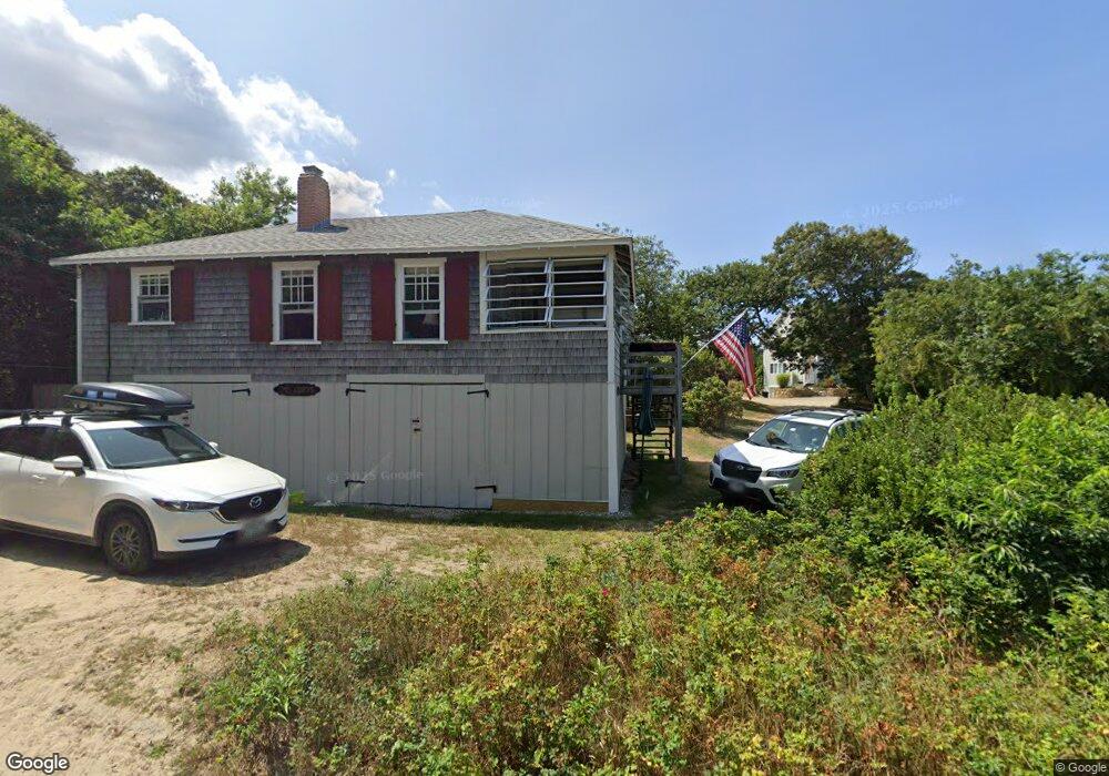
11 Captain Dunbar Rd Brewster, MA 02631
Estimated Value: $523,000 - $824,554
2
Beds
1
Bath
512
Sq Ft
$1,436/Sq Ft
Est. Value
About This Home
This home is located at 11 Captain Dunbar Rd, Brewster, MA 02631 and is currently estimated at $735,139, approximately $1,435 per square foot. 11 Captain Dunbar Rd is a home located in Barnstable County with nearby schools including Stony Brook Elementary School, Eddy Elementary School, and Nauset Regional Middle School.
Ownership History
Date
Name
Owned For
Owner Type
Purchase Details
Closed on
Dec 12, 2012
Sold by
Felice Gail A and Felice Donna J
Bought by
11 Captain Dunbar Road and Bundock Donna J
Current Estimated Value
Purchase Details
Closed on
Oct 8, 2010
Sold by
Felice Karen M
Bought by
Felice Gail A and Felice Donna J
Create a Home Valuation Report for This Property
The Home Valuation Report is an in-depth analysis detailing your home's value as well as a comparison with similar homes in the area
Home Values in the Area
Average Home Value in this Area
Purchase History
| Date | Buyer | Sale Price | Title Company |
|---|---|---|---|
| 11 Captain Dunbar Road | -- | -- | |
| Felice Gail A | -- | -- |
Source: Public Records
Tax History Compared to Growth
Tax History
| Year | Tax Paid | Tax Assessment Tax Assessment Total Assessment is a certain percentage of the fair market value that is determined by local assessors to be the total taxable value of land and additions on the property. | Land | Improvement |
|---|---|---|---|---|
| 2025 | $4,970 | $722,400 | $628,000 | $94,400 |
| 2024 | $4,642 | $681,700 | $592,500 | $89,200 |
| 2023 | $4,255 | $608,700 | $528,900 | $79,800 |
| 2022 | $3,982 | $507,300 | $440,600 | $66,700 |
| 2021 | $3,785 | $441,100 | $383,100 | $58,000 |
| 2020 | $3,779 | $438,400 | $383,100 | $55,300 |
| 2019 | $3,618 | $421,700 | $368,400 | $53,300 |
| 2018 | $2,998 | $363,000 | $311,800 | $51,200 |
| 2017 | $2,990 | $356,400 | $311,800 | $44,600 |
| 2016 | $2,946 | $349,500 | $305,700 | $43,800 |
| 2015 | $2,828 | $342,400 | $299,600 | $42,800 |
Source: Public Records
Map
Nearby Homes
- 195 Ellis Landing Rd
- 126 Bittersweet Dr
- 42 Landing Ln Unit 42
- 410 Blueberry Pond Dr
- 130 Millstone Rd Unit 12
- 28 Middlecott Ln
- 104 Sachemus Trail Unit 104
- 26 Pinewood Dr
- 277 Lund Farm Way
- 82 Middlecott Ln
- 261 Linnell Landing Rd Unit 2
- 261 Linnell Landing Rd Unit 1
- 20 Skipjack Way
- 105 Middlecott Ln Unit 105
- 46 Court Way
- 104 Howland Cir Unit 104
- 60 Fletcher Ln Unit H
- 60 Fletcher Ln Unit C
- 61 Fletcher Ln Unit H
- 62 Fletcher Ln Unit N
- 9 Captain Dunbar Rd
- 15 Captain Dunbar Rd
- 17 Captain Dunbar Rd
- 17 Captain Dunbar Rd Unit 17
- 5 Captain Dunbar Rd
- 169 Ellis Landing Rd
- 24 Captain Dunbar Rd
- 50 Kingfisher Cartway
- 189 Ellis Landing Rd
- 21 Captain Dunbar Rd
- 23 Captain Dunbar Rd
- 0 Captain Dunbar Rd Unit 15
- 42 Kingfisher Cartway
- 60 Kingfisher Cartway
- 27 Captain Dunbar Rd
- 161 Ellis Landing Rd
- 62 Kingfisher Cartway
- 34 Kingfisher Cartway
- 201 Ellis
- 201 Ellis Landing Rd