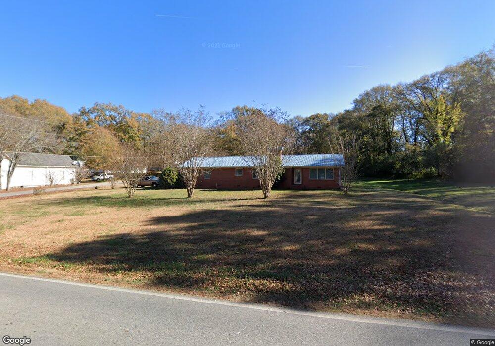
11 Crook St Senoia, GA 30276
Estimated Value: $324,071 - $358,000
3
Beds
2
Baths
1,493
Sq Ft
$227/Sq Ft
Est. Value
About This Home
This home is located at 11 Crook St, Senoia, GA 30276 and is currently estimated at $339,518, approximately $227 per square foot. 11 Crook St is a home located in Coweta County with nearby schools including Eastside Elementary School, East Coweta Middle School, and East Coweta High School.
Ownership History
Date
Name
Owned For
Owner Type
Purchase Details
Closed on
Apr 1, 2003
Sold by
Tinsley Karen C
Bought by
Nottingham Barry and Nottingham Patricia
Current Estimated Value
Home Financials for this Owner
Home Financials are based on the most recent Mortgage that was taken out on this home.
Original Mortgage
$112,632
Outstanding Balance
$48,635
Interest Rate
5.82%
Mortgage Type
FHA
Estimated Equity
$290,883
Purchase Details
Closed on
Nov 3, 1995
Bought by
Tinsley Karen C
Purchase Details
Closed on
Mar 31, 1987
Bought by
Banks Irene
Create a Home Valuation Report for This Property
The Home Valuation Report is an in-depth analysis detailing your home's value as well as a comparison with similar homes in the area
Home Values in the Area
Average Home Value in this Area
Purchase History
| Date | Buyer | Sale Price | Title Company |
|---|---|---|---|
| Nottingham Barry | $114,400 | -- | |
| Tinsley Karen C | -- | -- | |
| Banks Irene | -- | -- |
Source: Public Records
Mortgage History
| Date | Status | Borrower | Loan Amount |
|---|---|---|---|
| Open | Nottingham Barry | $112,632 |
Source: Public Records
Tax History Compared to Growth
Tax History
| Year | Tax Paid | Tax Assessment Tax Assessment Total Assessment is a certain percentage of the fair market value that is determined by local assessors to be the total taxable value of land and additions on the property. | Land | Improvement |
|---|---|---|---|---|
| 2024 | $1,434 | $101,442 | $38,454 | $62,989 |
| 2023 | $1,434 | $101,442 | $45,000 | $56,442 |
| 2022 | $877 | $72,673 | $18,400 | $54,273 |
| 2021 | $837 | $63,964 | $18,400 | $45,564 |
| 2020 | $928 | $63,964 | $18,400 | $45,564 |
| 2019 | $952 | $50,608 | $17,271 | $33,337 |
| 2018 | $961 | $50,608 | $17,271 | $33,337 |
| 2017 | $970 | $50,608 | $17,271 | $33,337 |
| 2016 | $969 | $50,608 | $17,271 | $33,337 |
| 2015 | $944 | $50,608 | $17,271 | $33,337 |
| 2014 | $1,295 | $39,814 | $6,477 | $33,337 |
Source: Public Records
Map
Nearby Homes
- 0 Quick Dr Unit 10555827
- 103 Morgan St
- 126 Morgan St
- 124 Morgan St
- 71 Lower Creek Trail
- 1978 Luther Bailey Rd
- 271 Bridge St
- 351 Seavy St
- 375 Luther Bailey Rd
- 0 Johnson St Unit 10612656
- 374 Luther Bailey Rd
- 146 Middle St
- 220 Johnson St
- 46 Horseshoe Bend Way
- 44 Standing Rock Rd
- 260 Willow Dell Dr
- 90 Howard Rd
- 65 Redhaven Dr
- 390 Redhaven Dr
- 0 Coweta St Unit 10555038
- 40 Luther Bailey Rd
- 71 Luther Bailey Rd
- 0 Quick Dr
- 0 Quick Dr Unit 10542821
- 0 Quick Dr Unit 10510532
- 0 Quick Dr Unit 10340475
- 0 Quick Dr Unit 3288732
- 0 Quick Dr Unit 8824499
- 26 Crook St
- 39 Luther Bailey Rd
- 0 Duck Dr Unit 38 8339634
- 0 Duck Dr Unit 30 8339640
- 0 Duck Dr Unit 8978458
- 0 Duck Dr Unit 8886088
- 0 Duck Dr Unit 8887385
- 0 Duck Dr Unit 8916549
- 0 Duck Dr Unit Lot 59 8811541
- 0 Duck Dr Unit 34 8339639
- 0 Duck Dr Unit 39 8339619
- 0 Duck Dr Unit 43 8339622