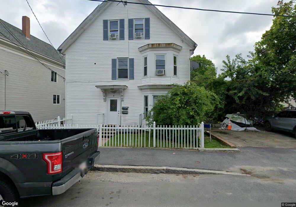
11 Forest St Gloucester, MA 01930
Central Gloucester NeighborhoodEstimated Value: $638,000 - $701,000
5
Beds
4
Baths
2,069
Sq Ft
$324/Sq Ft
Est. Value
About This Home
This home is located at 11 Forest St, Gloucester, MA 01930 and is currently estimated at $669,333, approximately $323 per square foot. 11 Forest St is a home located in Essex County with nearby schools including East Veterans Memorial Elementary, Ralph B O'maley Middle School, and Gloucester High School.
Ownership History
Date
Name
Owned For
Owner Type
Purchase Details
Closed on
Sep 14, 2018
Sold by
Deutsche Bk Natl T Co
Bought by
Razzaghi Khalil
Current Estimated Value
Purchase Details
Closed on
Oct 19, 2017
Sold by
Rowe Barbara
Bought by
Deutsche Bank Natl T C
Purchase Details
Closed on
Aug 28, 1998
Sold by
Usa
Bought by
Rowe Barbara
Purchase Details
Closed on
Aug 29, 1997
Sold by
Rowe Daniel J
Bought by
Usa
Purchase Details
Closed on
Mar 31, 1995
Sold by
Fhlmc
Bought by
Rowe Daniel J
Purchase Details
Closed on
Oct 17, 1994
Sold by
Anderson Richard N
Bought by
Fhlmc
Create a Home Valuation Report for This Property
The Home Valuation Report is an in-depth analysis detailing your home's value as well as a comparison with similar homes in the area
Home Values in the Area
Average Home Value in this Area
Purchase History
| Date | Buyer | Sale Price | Title Company |
|---|---|---|---|
| Razzaghi Khalil | $234,070 | -- | |
| Deutsche Bank Natl T C | $374,000 | -- | |
| Rowe Barbara | $143,600 | -- | |
| Usa | $103,752 | -- | |
| Rowe Daniel J | $119,900 | -- | |
| Fhlmc | $113,889 | -- |
Source: Public Records
Mortgage History
| Date | Status | Borrower | Loan Amount |
|---|---|---|---|
| Previous Owner | Fhlmc | $22,000 | |
| Previous Owner | Fhlmc | $255,000 | |
| Previous Owner | Fhlmc | $15,000 |
Source: Public Records
Tax History
| Year | Tax Paid | Tax Assessment Tax Assessment Total Assessment is a certain percentage of the fair market value that is determined by local assessors to be the total taxable value of land and additions on the property. | Land | Improvement |
|---|---|---|---|---|
| 2025 | $5,898 | $606,800 | $136,700 | $470,100 |
| 2024 | $5,505 | $565,800 | $130,100 | $435,700 |
| 2023 | $5,724 | $540,500 | $116,200 | $424,300 |
| 2022 | $5,199 | $443,200 | $101,100 | $342,100 |
| 2021 | $5,043 | $405,400 | $91,900 | $313,500 |
| 2020 | $4,787 | $388,200 | $91,900 | $296,300 |
| 2019 | $4,466 | $351,900 | $91,900 | $260,000 |
| 2018 | $4,302 | $332,700 | $91,900 | $240,800 |
| 2017 | $4,093 | $310,300 | $82,800 | $227,500 |
| 2016 | $3,805 | $279,600 | $82,700 | $196,900 |
| 2015 | $3,739 | $273,900 | $82,700 | $191,200 |
Source: Public Records
Map
Nearby Homes
- 19 Trask St Unit 2
- 50 Warner St
- 40 Sargent St
- 113 Pleasant St
- 12 Arthur St
- 33 Maplewood Ave Unit 310
- 9 Cleveland Place
- 139A Prospect St
- 98 Maplewood Ave
- 8 Mystic Ave
- 13 Mystic Ave
- 191 Main St Unit 3
- 191 Main St Unit 2A
- 120 Washington St
- 36 Eastern Ave
- 35 Middle St Unit 4
- 33 Middle St
- 6 Monroe Ct
- 20 Beacon St
- 20 Beacon St Unit 2
Your Personal Tour Guide
Ask me questions while you tour the home.