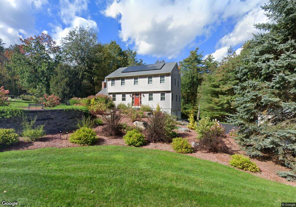
11 Fox Run Rd Sterling, MA 01564
Estimated Value: $545,000 - $698,658
4
Beds
3
Baths
2,160
Sq Ft
$284/Sq Ft
Est. Value
About This Home
This home is located at 11 Fox Run Rd, Sterling, MA 01564 and is currently estimated at $612,415, approximately $283 per square foot. 11 Fox Run Rd is a home located in Worcester County with nearby schools including Wachusett Regional High School.
Ownership History
Date
Name
Owned For
Owner Type
Purchase Details
Closed on
Mar 28, 2016
Sold by
Reynolds John D and Reynolds Karla
Bought by
Reynolds Lt
Current Estimated Value
Purchase Details
Closed on
Jun 15, 2004
Sold by
Hamlet At Blackstone I
Bought by
Stevens Donna L and Stevens Laburton E
Purchase Details
Closed on
Oct 25, 1999
Sold by
Mckenzie William W and Mckenzie Joanm
Bought by
Reynolds John D and Reynolds Karla C
Home Financials for this Owner
Home Financials are based on the most recent Mortgage that was taken out on this home.
Original Mortgage
$220,000
Interest Rate
7.83%
Mortgage Type
Purchase Money Mortgage
Create a Home Valuation Report for This Property
The Home Valuation Report is an in-depth analysis detailing your home's value as well as a comparison with similar homes in the area
Home Values in the Area
Average Home Value in this Area
Purchase History
| Date | Buyer | Sale Price | Title Company |
|---|---|---|---|
| Reynolds Lt | -- | -- | |
| Stevens Donna L | $241,825 | -- | |
| Reynolds John D | $275,000 | -- |
Source: Public Records
Mortgage History
| Date | Status | Borrower | Loan Amount |
|---|---|---|---|
| Previous Owner | Reynolds John D | $188,500 | |
| Previous Owner | Reynolds John D | $220,000 | |
| Previous Owner | Reynolds John D | $30,000 | |
| Previous Owner | Reynolds John D | $161,250 |
Source: Public Records
Tax History Compared to Growth
Tax History
| Year | Tax Paid | Tax Assessment Tax Assessment Total Assessment is a certain percentage of the fair market value that is determined by local assessors to be the total taxable value of land and additions on the property. | Land | Improvement |
|---|---|---|---|---|
| 2025 | $7,295 | $566,400 | $200,700 | $365,700 |
| 2024 | $7,142 | $536,600 | $194,600 | $342,000 |
| 2023 | $6,808 | $476,100 | $186,500 | $289,600 |
| 2022 | $6,152 | $403,400 | $165,200 | $238,200 |
| 2021 | $3,963 | $379,000 | $162,500 | $216,500 |
| 2020 | $6,566 | $390,600 | $175,600 | $215,000 |
| 2019 | $3,969 | $369,400 | $175,600 | $193,800 |
| 2018 | $0 | $359,000 | $169,300 | $189,700 |
| 2017 | $0 | $342,300 | $156,500 | $185,800 |
| 2016 | $6,111 | $333,400 | $156,500 | $176,900 |
| 2015 | $5,718 | $330,700 | $156,000 | $174,700 |
| 2014 | $5,517 | $325,900 | $156,000 | $169,900 |
Source: Public Records
Map
Nearby Homes