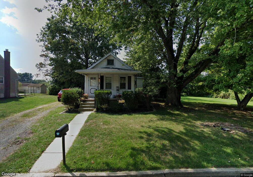
11 Heath St Ewing, NJ 08638
Braeburn Heights NeighborhoodEstimated Value: $198,000 - $294,684
2
Beds
1
Bath
1,038
Sq Ft
$250/Sq Ft
Est. Value
About This Home
This home is located at 11 Heath St, Ewing, NJ 08638 and is currently estimated at $259,921, approximately $250 per square foot. 11 Heath St is a home located in Mercer County with nearby schools including Ewing High School, Paul Robeson Charter School For The Humanities, and Trenton Stem-To-Civics Charter School.
Ownership History
Date
Name
Owned For
Owner Type
Purchase Details
Closed on
Aug 20, 2024
Sold by
Baptiste Emsley
Bought by
Nissi Home Improvement Llc
Current Estimated Value
Home Financials for this Owner
Home Financials are based on the most recent Mortgage that was taken out on this home.
Original Mortgage
$208,000
Interest Rate
6.2%
Mortgage Type
New Conventional
Purchase Details
Closed on
Jul 16, 2024
Sold by
Baptiste Emsley
Bought by
Baptiste Emsley
Home Financials for this Owner
Home Financials are based on the most recent Mortgage that was taken out on this home.
Original Mortgage
$208,000
Interest Rate
6.2%
Mortgage Type
New Conventional
Purchase Details
Closed on
Aug 30, 2010
Sold by
Evanko M William
Bought by
Halcak Richard
Create a Home Valuation Report for This Property
The Home Valuation Report is an in-depth analysis detailing your home's value as well as a comparison with similar homes in the area
Home Values in the Area
Average Home Value in this Area
Purchase History
| Date | Buyer | Sale Price | Title Company |
|---|---|---|---|
| Nissi Home Improvement Llc | -- | Eastcor National Title | |
| Baptiste Emsley | -- | None Listed On Document | |
| Baptiste Emsley | -- | None Listed On Document | |
| Halcak Richard | $160,000 | None Available |
Source: Public Records
Mortgage History
| Date | Status | Borrower | Loan Amount |
|---|---|---|---|
| Previous Owner | Nissi Home Improvement Llc | $208,000 |
Source: Public Records
Tax History Compared to Growth
Tax History
| Year | Tax Paid | Tax Assessment Tax Assessment Total Assessment is a certain percentage of the fair market value that is determined by local assessors to be the total taxable value of land and additions on the property. | Land | Improvement |
|---|---|---|---|---|
| 2025 | $5,157 | $134,500 | $48,500 | $86,000 |
| 2024 | $5,157 | $139,500 | $53,500 | $86,000 |
| 2023 | $5,157 | $139,500 | $53,500 | $86,000 |
| 2022 | $5,018 | $139,500 | $53,500 | $86,000 |
| 2021 | $4,895 | $139,500 | $53,500 | $86,000 |
| 2020 | $4,825 | $139,500 | $53,500 | $86,000 |
| 2019 | $4,700 | $139,500 | $53,500 | $86,000 |
| 2018 | $4,162 | $78,800 | $46,100 | $32,700 |
| 2017 | $4,259 | $78,800 | $46,100 | $32,700 |
| 2016 | $4,202 | $78,800 | $46,100 | $32,700 |
| 2015 | $4,146 | $78,800 | $46,100 | $32,700 |
| 2014 | $4,135 | $78,800 | $46,100 | $32,700 |
Source: Public Records
Map
Nearby Homes
- 7 Mabel St
- 41 Poland St
- 56 Shelburne Dr
- 14 Chesney Ave
- 56 Sherbrooke Rd
- 137 Ardsley Ave
- 9 Auburn Ave
- 10 Blossom Dr
- 9 Blossom Dr
- 16 Shelburne Dr
- 200 Upland Ave
- 4 Blossom Dr
- 107 Hawthorne Ave
- 200 Claflin Ave
- 186 Upland Ave
- 50 Hillman Ave
- 38 Running Brook Rd
- 256 Ewingville Rd
- 117 Browning Ave
- 194 Woodland Ave