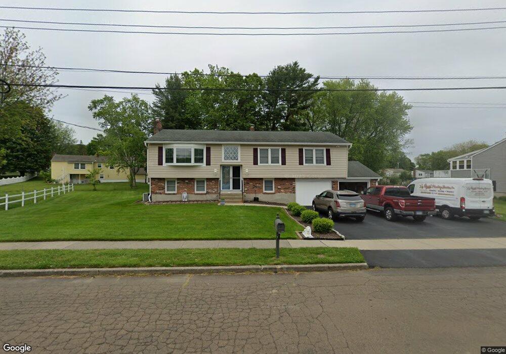
11 Homesteader Ln West Haven, CT 06516
West Shore NeighborhoodEstimated Value: $441,000 - $484,000
3
Beds
2
Baths
1,288
Sq Ft
$356/Sq Ft
Est. Value
About This Home
This home is located at 11 Homesteader Ln, West Haven, CT 06516 and is currently estimated at $458,379, approximately $355 per square foot. 11 Homesteader Ln is a home located in New Haven County with nearby schools including Carrigan 5/6 Intermediate School, Harry M. Bailey Middle School, and West Haven High School.
Ownership History
Date
Name
Owned For
Owner Type
Purchase Details
Closed on
Dec 1, 1992
Sold by
Glass Paula
Bought by
Dellavalle Frank and Dellavalle Linda M
Current Estimated Value
Home Financials for this Owner
Home Financials are based on the most recent Mortgage that was taken out on this home.
Original Mortgage
$64,900
Interest Rate
8.06%
Mortgage Type
Purchase Money Mortgage
Create a Home Valuation Report for This Property
The Home Valuation Report is an in-depth analysis detailing your home's value as well as a comparison with similar homes in the area
Home Values in the Area
Average Home Value in this Area
Purchase History
| Date | Buyer | Sale Price | Title Company |
|---|---|---|---|
| Dellavalle Frank | $164,900 | -- |
Source: Public Records
Mortgage History
| Date | Status | Borrower | Loan Amount |
|---|---|---|---|
| Open | Dellavalle Frank | $91,000 | |
| Closed | Dellavalle Frank | $138,000 | |
| Closed | Dellavalle Frank | $64,900 | |
| Previous Owner | Dellavalle Frank | $31,000 |
Source: Public Records
Tax History Compared to Growth
Tax History
| Year | Tax Paid | Tax Assessment Tax Assessment Total Assessment is a certain percentage of the fair market value that is determined by local assessors to be the total taxable value of land and additions on the property. | Land | Improvement |
|---|---|---|---|---|
| 2025 | $9,523 | $289,730 | $90,930 | $198,800 |
| 2024 | $9,158 | $195,440 | $63,000 | $132,440 |
| 2023 | $8,814 | $195,440 | $63,000 | $132,440 |
| 2022 | $8,656 | $195,440 | $63,000 | $132,440 |
| 2021 | $8,656 | $195,440 | $63,000 | $132,440 |
| 2020 | $8,673 | $178,430 | $58,450 | $119,980 |
| 2019 | $8,397 | $178,430 | $58,450 | $119,980 |
| 2018 | $8,277 | $178,430 | $58,450 | $119,980 |
| 2017 | $8,054 | $178,430 | $58,450 | $119,980 |
| 2016 | $7,965 | $178,430 | $58,450 | $119,980 |
| 2015 | $7,973 | $199,920 | $62,230 | $137,690 |
| 2014 | $7,973 | $199,920 | $62,230 | $137,690 |
Source: Public Records
Map
Nearby Homes
- 9 Homesteader Ln
- 15 Homesteader Ln
- 278 Jones Hill Rd
- 2 Bridle Path Ln
- 14 Cowpen Rd
- 6 Homesteader Ln
- 348 Jones Hill Rd
- 17 Homesteader Ln
- 3 Bridle Path Ln
- 4 Bridle Path Ln
- 15 Cowpen Rd
- 270 Jones Hill Rd
- 8 Cowpen Rd
- 16 Cowpen Rd
- 5 Bridle Path Ln
- 279 Jones Hill Rd
- 350 Jones Hill Rd
- 14 Homesteader Ln
- 285 Jones Hill Rd
- 19 Homesteader Ln