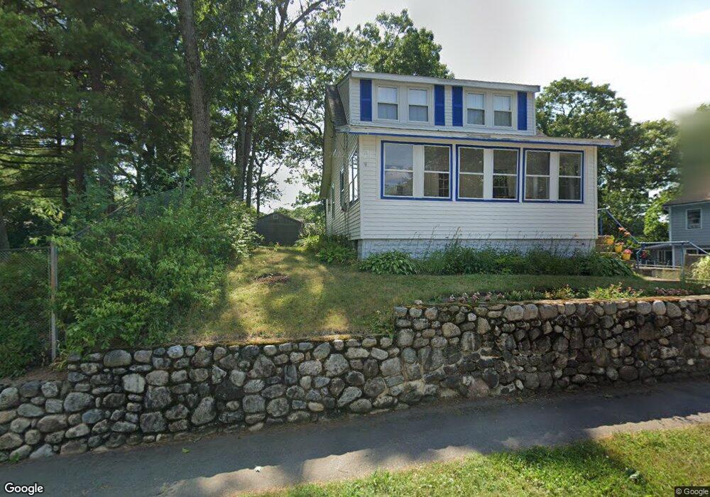
11 Laconia Rd Natick, MA 01760
Estimated Value: $552,000 - $723,000
3
Beds
2
Baths
1,017
Sq Ft
$617/Sq Ft
Est. Value
About This Home
This home is located at 11 Laconia Rd, Natick, MA 01760 and is currently estimated at $627,971, approximately $617 per square foot. 11 Laconia Rd is a home located in Middlesex County with nearby schools including Natick High School, Lilja Elementary School, and Wilson Middle School.
Ownership History
Date
Name
Owned For
Owner Type
Purchase Details
Closed on
Nov 26, 2013
Sold by
Leslie Ann Davis T
Bought by
Leslie Ann Davis T
Current Estimated Value
Purchase Details
Closed on
Jul 30, 2004
Sold by
Davies Leslie
Bought by
Leslie Ann Davies Rt
Purchase Details
Closed on
Aug 5, 2002
Sold by
Patwardhan Nathan V
Bought by
Davies Leslie
Home Financials for this Owner
Home Financials are based on the most recent Mortgage that was taken out on this home.
Original Mortgage
$100,000
Interest Rate
6.64%
Mortgage Type
Purchase Money Mortgage
Purchase Details
Closed on
Aug 3, 1998
Sold by
Kent Irene E
Bought by
Patwardhan Nathan V
Home Financials for this Owner
Home Financials are based on the most recent Mortgage that was taken out on this home.
Original Mortgage
$171,000
Interest Rate
6.92%
Mortgage Type
Purchase Money Mortgage
Create a Home Valuation Report for This Property
The Home Valuation Report is an in-depth analysis detailing your home's value as well as a comparison with similar homes in the area
Home Values in the Area
Average Home Value in this Area
Purchase History
| Date | Buyer | Sale Price | Title Company |
|---|---|---|---|
| Leslie Ann Davis T | -- | -- | |
| Leslie Ann Davies Rt | -- | -- | |
| Davies Leslie | $280,000 | -- | |
| Patwardhan Nathan V | $191,000 | -- |
Source: Public Records
Mortgage History
| Date | Status | Borrower | Loan Amount |
|---|---|---|---|
| Previous Owner | Patwardhan Nathan V | $79,000 | |
| Previous Owner | Davies Leslie | $100,000 | |
| Previous Owner | Patwardhan Nathan V | $168,000 | |
| Previous Owner | Patwardhan Nathan V | $171,000 | |
| Previous Owner | Patwardhan Nathan V | $132,600 |
Source: Public Records
Tax History Compared to Growth
Tax History
| Year | Tax Paid | Tax Assessment Tax Assessment Total Assessment is a certain percentage of the fair market value that is determined by local assessors to be the total taxable value of land and additions on the property. | Land | Improvement |
|---|---|---|---|---|
| 2025 | $6,210 | $519,200 | $366,500 | $152,700 |
| 2024 | $5,987 | $488,300 | $345,000 | $143,300 |
| 2023 | $6,116 | $483,900 | $332,000 | $151,900 |
| 2022 | $5,879 | $440,700 | $301,900 | $138,800 |
| 2021 | $5,645 | $414,800 | $284,600 | $130,200 |
| 2020 | $5,470 | $401,900 | $271,700 | $130,200 |
| 2019 | $5,108 | $401,900 | $271,700 | $130,200 |
| 2018 | $4,493 | $344,300 | $258,800 | $85,500 |
| 2017 | $4,100 | $303,900 | $219,900 | $84,000 |
| 2016 | $3,694 | $272,200 | $189,000 | $83,200 |
| 2015 | $3,669 | $265,500 | $189,000 | $76,500 |
Source: Public Records
Map
Nearby Homes