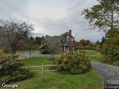
11 Lighthouse Point Rd Cape Elizabeth, ME 04107
Estimated Value: $1,224,000 - $1,523,000
4
Beds
3
Baths
3,663
Sq Ft
$371/Sq Ft
Est. Value
About This Home
This home is located at 11 Lighthouse Point Rd, Cape Elizabeth, ME 04107 and is currently estimated at $1,358,002, approximately $370 per square foot. 11 Lighthouse Point Rd is a home located in Cumberland County with nearby schools including Pond Cove Elementary School, Cape Elizabeth Middle School, and Cape Elizabeth High School.
Ownership History
Date
Name
Owned For
Owner Type
Purchase Details
Closed on
Jul 11, 2017
Sold by
Eldrup-Jorgensen Jens
Bought by
Nolan Brian W and Scully Danielle
Current Estimated Value
Home Financials for this Owner
Home Financials are based on the most recent Mortgage that was taken out on this home.
Original Mortgage
$753,000
Interest Rate
3.95%
Mortgage Type
Purchase Money Mortgage
Create a Home Valuation Report for This Property
The Home Valuation Report is an in-depth analysis detailing your home's value as well as a comparison with similar homes in the area
Home Values in the Area
Average Home Value in this Area
Purchase History
| Date | Buyer | Sale Price | Title Company |
|---|---|---|---|
| Nolan Brian W | -- | -- |
Source: Public Records
Mortgage History
| Date | Status | Borrower | Loan Amount |
|---|---|---|---|
| Open | Nolan Brian W | $707,000 | |
| Closed | Nolaw Brian W | $707,000 | |
| Closed | Nolan Brian W | $450,000 | |
| Closed | Nolan Brian W | $753,000 | |
| Previous Owner | Eldrup-Jorgensen Jens | $200,000 | |
| Previous Owner | Eldrup-Jorgensen Jens | $50,000 | |
| Previous Owner | Eldrup-Jorgensen Jens | $100,000 |
Source: Public Records
Tax History Compared to Growth
Tax History
| Year | Tax Paid | Tax Assessment Tax Assessment Total Assessment is a certain percentage of the fair market value that is determined by local assessors to be the total taxable value of land and additions on the property. | Land | Improvement |
|---|---|---|---|---|
| 2024 | $9,984 | $907,600 | $457,400 | $450,200 |
| 2023 | $20,276 | $907,600 | $457,400 | $450,200 |
| 2022 | $12,940 | $611,800 | $246,800 | $365,000 |
| 2021 | $12,395 | $611,800 | $246,800 | $365,000 |
| 2020 | $12,187 | $611,800 | $246,800 | $365,000 |
| 2019 | $12,040 | $611,800 | $246,800 | $365,000 |
| 2018 | $11,636 | $611,800 | $246,800 | $365,000 |
| 2017 | $11,012 | $611,800 | $246,800 | $365,000 |
| 2016 | $10,731 | $611,800 | $246,800 | $365,000 |
| 2015 | $10,327 | $611,800 | $246,800 | $365,000 |
| 2013 | $9,960 | $611,800 | $246,800 | $365,000 |
Source: Public Records
Map
Nearby Homes
- 7 Dyer Ln
- 3 Channel View Rd
- 124 Old Ocean House Rd
- 1 Wabun Rd
- 2 Oak Knoll Rd
- 25 Peabbles Cove Rd
- 41 Old Mill Rd
- 3 Great Pond Terrace
- 40 Zeb Cove Rd
- 1200 Shore Rd
- 317 Fowler Rd
- 49 Longfellow Dr
- 36 Farm Hill Rd
- 530 Spurwink Ave
- 3 Canter Ln
- 2 Evergreen Cir
- 13 Juniper Ln
- 80 Wells Rd
- 539 Mitchell Rd
- 1055 Shore Rd
- 11 Lighthouse Point Rd
- 15 Lighthouse Point Rd
- 10 Lighthouse Point Rd
- 12 Lighthouse Point Rd
- 8 Lighthouse Point Rd
- 40 Sunrise Dr
- 17 Brook Rd
- 4 Lighthouse Point Rd
- 4 Light House Pt Rd
- 20 Cunner Ln
- 15 Two Lights Terrace
- 11 Two Lights Terrace
- 0 Brook Rd
- 7 Brook Rd
- 2 Lighthouse Point Rd
- 7 Lighthouse Point Rd
- 2 Beacon Ln
- 16 Two Lights Terrace
- 12 Two Lights Terrace
- 4 Brook Rd