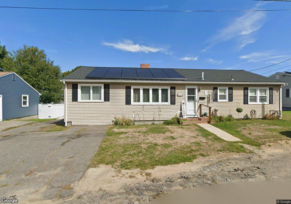
11 Linden Rd Gloucester, MA 01930
Riverview NeighborhoodEstimated Value: $692,849 - $819,000
4
Beds
2
Baths
1,560
Sq Ft
$494/Sq Ft
Est. Value
About This Home
This home is located at 11 Linden Rd, Gloucester, MA 01930 and is currently estimated at $770,212, approximately $493 per square foot. 11 Linden Rd is a home located in Essex County with nearby schools including Beeman Memorial, Ralph B O'maley Middle School, and Gloucester High School.
Ownership History
Date
Name
Owned For
Owner Type
Purchase Details
Closed on
Apr 17, 2015
Sold by
Linsky Stephen E and Linsky Jane E
Bought by
Linsky Ft
Current Estimated Value
Purchase Details
Closed on
Jul 1, 1980
Bought by
Linsky Stephen and Linsky Jane E
Create a Home Valuation Report for This Property
The Home Valuation Report is an in-depth analysis detailing your home's value as well as a comparison with similar homes in the area
Home Values in the Area
Average Home Value in this Area
Purchase History
| Date | Buyer | Sale Price | Title Company |
|---|---|---|---|
| Linsky Ft | -- | -- | |
| Linsky Stephen | $49,000 | -- |
Source: Public Records
Mortgage History
| Date | Status | Borrower | Loan Amount |
|---|---|---|---|
| Previous Owner | Linsky Stephen | $120,000 | |
| Previous Owner | Linsky Stephen | $125,000 | |
| Previous Owner | Linsky Stephen | $40,000 |
Source: Public Records
Tax History
| Year | Tax Paid | Tax Assessment Tax Assessment Total Assessment is a certain percentage of the fair market value that is determined by local assessors to be the total taxable value of land and additions on the property. | Land | Improvement |
|---|---|---|---|---|
| 2025 | $5,188 | $533,700 | $205,400 | $328,300 |
| 2024 | $5,048 | $518,800 | $195,600 | $323,200 |
| 2023 | $5,069 | $478,700 | $174,700 | $304,000 |
| 2022 | $4,754 | $405,300 | $148,500 | $256,800 |
| 2021 | $4,778 | $384,100 | $135,000 | $249,100 |
| 2020 | $4,640 | $376,300 | $135,000 | $241,300 |
| 2019 | $4,587 | $361,500 | $135,000 | $226,500 |
| 2018 | $4,523 | $349,800 | $135,000 | $214,800 |
| 2017 | $4,404 | $333,900 | $128,600 | $205,300 |
| 2016 | $4,161 | $305,700 | $129,000 | $176,700 |
| 2015 | -- | $300,300 | $129,000 | $171,300 |
Source: Public Records
Map
Nearby Homes
- 13 Honeysuckle Rd
- 3 Deacon Farm Ln
- 31 Echo Ave
- 2 Breezy Point Rd
- 3 Rockland St
- 6 Monroe Ct
- 13 Mystic Ave
- 8 Mystic Ave
- 98 Maplewood Ave
- 167 Atlantic St
- 145 Essex Ave Unit 402
- 9 Cleveland Place
- 178 Atlantic St
- 15 Harvard St
- 12 Arthur St
- 5 Samoset Rd Unit B
- 24 Cobblestone Ln Unit 603
- 5 Lepage Ln
- 672 Washington St
- 40 Sargent St
Your Personal Tour Guide
Ask me questions while you tour the home.