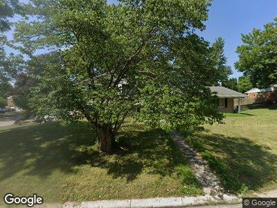
11 Lynn Rae Cir Dayton, OH 45458
Estimated Value: $284,000 - $299,000
3
Beds
3
Baths
2,210
Sq Ft
$132/Sq Ft
Est. Value
About This Home
This home is located at 11 Lynn Rae Cir, Dayton, OH 45458 and is currently estimated at $291,055, approximately $131 per square foot. 11 Lynn Rae Cir is a home located in Montgomery County with nearby schools including Primary Village South, Cline Elementary, and Magsig Middle School.
Ownership History
Date
Name
Owned For
Owner Type
Purchase Details
Closed on
Jun 22, 2017
Sold by
Hufnagle David R
Bought by
Marshall Kaiser Swawnmari
Current Estimated Value
Home Financials for this Owner
Home Financials are based on the most recent Mortgage that was taken out on this home.
Original Mortgage
$116,000
Interest Rate
3.9%
Mortgage Type
New Conventional
Purchase Details
Closed on
Oct 20, 2015
Sold by
Hufnagle David R and Hufnagle Mary S
Bought by
Hufnagle Kenneth and Hufnagle Family Revocable Living Trust
Create a Home Valuation Report for This Property
The Home Valuation Report is an in-depth analysis detailing your home's value as well as a comparison with similar homes in the area
Home Values in the Area
Average Home Value in this Area
Purchase History
| Date | Buyer | Sale Price | Title Company |
|---|---|---|---|
| Marshall Kaiser Swawnmari | $145,000 | Vantage Land Title | |
| Hufnagle Kenneth | -- | Attorney |
Source: Public Records
Mortgage History
| Date | Status | Borrower | Loan Amount |
|---|---|---|---|
| Open | Marshall Kaiser Shawanmari | $160,000 | |
| Closed | Marshall Kaiser Swawnmari | $116,000 | |
| Previous Owner | Hufnagle David R | $58,341 | |
| Previous Owner | Hufnagle David R | $103,600 | |
| Previous Owner | Hufnagle David | $75,000 | |
| Previous Owner | Hufnagle David R | $50,000 |
Source: Public Records
Tax History Compared to Growth
Tax History
| Year | Tax Paid | Tax Assessment Tax Assessment Total Assessment is a certain percentage of the fair market value that is determined by local assessors to be the total taxable value of land and additions on the property. | Land | Improvement |
|---|---|---|---|---|
| 2024 | $4,013 | $69,010 | $14,220 | $54,790 |
| 2023 | $4,013 | $69,010 | $14,220 | $54,790 |
| 2022 | $3,982 | $54,310 | $11,200 | $43,110 |
| 2021 | $3,992 | $54,310 | $11,200 | $43,110 |
| 2020 | $3,987 | $54,310 | $11,200 | $43,110 |
| 2019 | $4,396 | $53,480 | $11,200 | $42,280 |
| 2018 | $3,897 | $53,480 | $11,200 | $42,280 |
| 2017 | $3,226 | $53,480 | $11,200 | $42,280 |
| 2016 | $3,218 | $50,860 | $11,200 | $39,660 |
| 2015 | $3,185 | $50,860 | $11,200 | $39,660 |
| 2014 | $3,185 | $50,860 | $11,200 | $39,660 |
| 2012 | -- | $52,490 | $11,200 | $41,290 |
Source: Public Records
Map
Nearby Homes
- 8124 Julian Place
- 311 Windsor Park Dr
- 7758 Normandy Ln
- 410 Gwinnett Commons Unit 17
- 7686 Brams Hill Dr
- 77 Laura Ave
- 108 Mallard Glen Dr Unit 7
- 144 Tuxworth Rd
- 481 Beth Page Cir Unit 74817
- 8836 Washington Colony Dr Unit 16
- 8408 Royal Birkdale Dr Unit 68408
- 755 Hidden Cir Unit 623
- 294 Waterford Dr
- 275 Boyce Rd
- 797 Hidden Cir Unit 26
- 729 Clareridge Ln Unit 729
- 765 Clareridge Ln Unit 765
- 275 Bethel Rd
- 7789 Thomas Jefferson Ln Unit 1689
- 749 Clareridge Ln Unit 749
- 11 Lynn Rae Cir
- 20 Gershwin Dr
- 21 Lynn Rae Cir
- 20 Lynn Rae Cir
- 41 Gershwin Dr
- 51 Gershwin Dr
- 30 Lynn Rae Cir
- 31 Gershwin Dr
- 31 Lynn Rae Cir
- 61 Gershwin Dr
- 21 Gershwin Dr
- 90 Lynn Rae Cir
- 80 Lynn Rae Cir
- 41 Lynn Rae Cir
- 71 Gershwin Dr
- 51 Lynn Rae Cir
- 252 W Franklin St
- 262 W Franklin St
- 61 Lynn Rae Cir
- 81 Gershwin Dr
