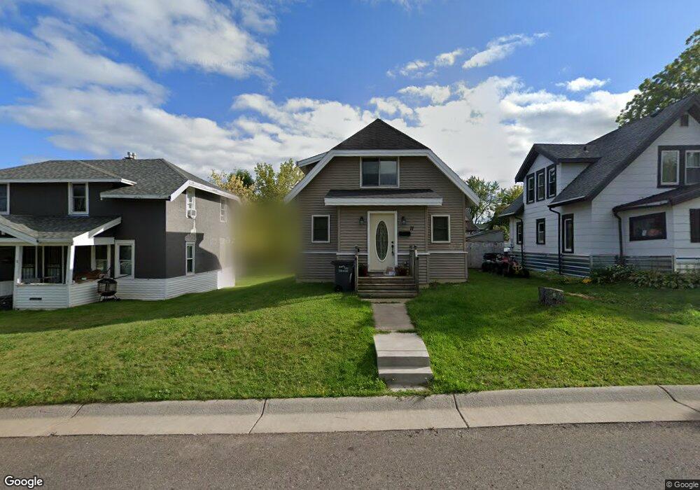
11 Manitou St Duluth, MN 55808
Riverside NeighborhoodEstimated Value: $167,089 - $219,000
2
Beds
1
Bath
1,078
Sq Ft
$180/Sq Ft
Est. Value
About This Home
This home is located at 11 Manitou St, Duluth, MN 55808 and is currently estimated at $194,522, approximately $180 per square foot. 11 Manitou St is a home located in St. Louis County with nearby schools including Stowe Elementary School, Lincoln Park Middle School, and Denfeld High School.
Ownership History
Date
Name
Owned For
Owner Type
Purchase Details
Closed on
Nov 2, 2018
Sold by
Kohl Dawn M
Bought by
Rodenwald Ronald R and Rodenwald Cynthia
Current Estimated Value
Purchase Details
Closed on
Aug 28, 2018
Sold by
Rodenwald Robert and Rodenwald Christine
Bought by
Kohi Dawn M
Purchase Details
Closed on
Oct 13, 2006
Sold by
Matuszewski Sherry L
Bought by
Rodenwald Robert
Purchase Details
Closed on
May 29, 2002
Sold by
Lindberg Bryan A and Lindberg Maureen
Bought by
Matuszewski Sherry L
Purchase Details
Closed on
May 20, 2002
Sold by
The Bank Of New York
Bought by
Lindberg Bryan A
Purchase Details
Closed on
May 23, 2001
Sold by
Old Standard Life Insurance Company
Bought by
Bank Of New York and Tyron Mtg Pass Through Certificates Seri
Create a Home Valuation Report for This Property
The Home Valuation Report is an in-depth analysis detailing your home's value as well as a comparison with similar homes in the area
Home Values in the Area
Average Home Value in this Area
Purchase History
| Date | Buyer | Sale Price | Title Company |
|---|---|---|---|
| Rodenwald Ronald R | -- | None Available | |
| Kohi Dawn M | $15,000 | None Available | |
| Rodenwald Robert | $15,000 | Rels | |
| Matuszewski Sherry L | $35,000 | Ati Title Company | |
| Lindberg Bryan A | $35,000 | Ati | |
| Bank Of New York | -- | -- | |
| Bank Of New York | -- | -- |
Source: Public Records
Tax History Compared to Growth
Tax History
| Year | Tax Paid | Tax Assessment Tax Assessment Total Assessment is a certain percentage of the fair market value that is determined by local assessors to be the total taxable value of land and additions on the property. | Land | Improvement |
|---|---|---|---|---|
| 2024 | $2,186 | $158,100 | $10,100 | $148,000 |
| 2023 | $2,186 | $158,100 | $10,100 | $148,000 |
| 2022 | $2,090 | $120,300 | $9,500 | $110,800 |
| 2021 | $1,836 | $105,600 | $8,300 | $97,300 |
| 2020 | $1,880 | $92,100 | $7,300 | $84,800 |
| 2019 | $1,756 | $92,100 | $7,300 | $84,800 |
| 2018 | $1,534 | $85,300 | $7,300 | $78,000 |
| 2017 | $1,532 | $76,700 | $7,400 | $69,300 |
| 2016 | $1,504 | $76,700 | $7,400 | $69,300 |
| 2015 | $1,200 | $76,700 | $7,400 | $69,300 |
| 2014 | $1,192 | $76,700 | $7,400 | $69,300 |
Source: Public Records
Map
Nearby Homes
- 31 England Ave
- 37 Cato Ave
- 125 Goldys Way
- 8408 Potters Place
- 8415 Burns Ct
- 121 Goldys Way
- 8402 Eric Shaffer Way
- 8313 Eric Shaffer Way
- 121 Kayak View
- 8610 Maynard Place
- 8602 Maynard Place
- 423 N 84th Ave W
- 3xx N 83rd Ave W
- 9211 Keene Ave
- 322 N 80th Ave W
- 8825 Arbor St
- 9501 Seaver Ave
- 919 89th Ave W
- 523 S 72nd Ave W
- 20 Village Dr Unit 206