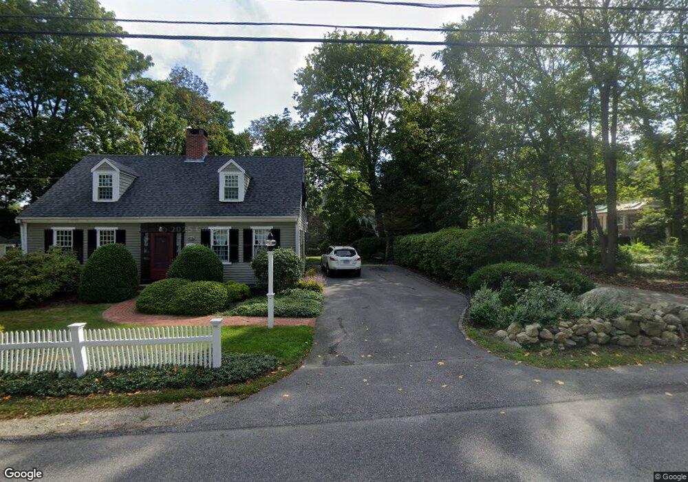
11 Mann Lot Rd Scituate, MA 02066
Estimated Value: $1,540,467 - $2,019,000
4
Beds
3
Baths
3,665
Sq Ft
$469/Sq Ft
Est. Value
About This Home
This home is located at 11 Mann Lot Rd, Scituate, MA 02066 and is currently estimated at $1,719,367, approximately $469 per square foot. 11 Mann Lot Rd is a home located in Plymouth County with nearby schools including Hatherly Elementary School, Lester J. Gates Middle School, and Scituate High School.
Ownership History
Date
Name
Owned For
Owner Type
Purchase Details
Closed on
Mar 18, 2005
Sold by
Whitney Susan M and Whitney Daniel F X
Bought by
Whitney Susan M
Current Estimated Value
Purchase Details
Closed on
Jun 13, 2000
Sold by
Sile Rt and Belek Elizabeth
Bought by
Whitney Susan M and Whitney Daniel Fx
Purchase Details
Closed on
Apr 14, 1999
Sold by
First Baptist Church and Miles Paul R
Bought by
Sile Rt and Belek Elizabeth
Create a Home Valuation Report for This Property
The Home Valuation Report is an in-depth analysis detailing your home's value as well as a comparison with similar homes in the area
Home Values in the Area
Average Home Value in this Area
Purchase History
| Date | Buyer | Sale Price | Title Company |
|---|---|---|---|
| Whitney Susan M | -- | -- | |
| Whitney Susan M | $175,000 | -- | |
| Sile Rt | $135,000 | -- |
Source: Public Records
Mortgage History
| Date | Status | Borrower | Loan Amount |
|---|---|---|---|
| Open | Sile Rt | $724,000 | |
| Previous Owner | Sile Rt | $322,700 | |
| Previous Owner | Sile Rt | $100,000 |
Source: Public Records
Tax History Compared to Growth
Tax History
| Year | Tax Paid | Tax Assessment Tax Assessment Total Assessment is a certain percentage of the fair market value that is determined by local assessors to be the total taxable value of land and additions on the property. | Land | Improvement |
|---|---|---|---|---|
| 2025 | $11,918 | $1,193,000 | $385,200 | $807,800 |
| 2024 | $11,837 | $1,142,600 | $350,200 | $792,400 |
| 2023 | $12,033 | $1,081,100 | $337,500 | $743,600 |
| 2022 | $12,144 | $962,300 | $328,900 | $633,400 |
| 2021 | $6,788 | $883,000 | $313,300 | $569,700 |
| 2020 | $6,719 | $851,100 | $301,200 | $549,900 |
| 2019 | $11,278 | $820,800 | $295,300 | $525,500 |
| 2018 | $6,640 | $793,100 | $305,100 | $488,000 |
| 2017 | $10,739 | $762,200 | $292,900 | $469,300 |
| 2016 | $10,432 | $737,800 | $268,500 | $469,300 |
| 2015 | $9,505 | $725,600 | $256,300 | $469,300 |
Source: Public Records
Map
Nearby Homes
- 112 Hollett St
- 16 3 Ring Rd
- 26 Mordecai Lincoln Rd
- 11 Forest Ln
- 9 Forest Ln Unit 9
- 8 Westgate Ln
- 84 Booth Hill Rd
- 9 Kyle Path
- 14 Aberdeen Dr
- 53 Border St
- 8 Trudys Ln
- 7 Border St
- 59 Captain Peirce Rd
- 817 Country Way
- 42 Captain Peirce Rd
- 1 Hillside Rd
- 392 S Main St
- 54 Woodland Rd
- 29 Country Club Cir
- 46 Marys Ln
- 15 Mann Lot Rd
- 9 Mann Lot Rd
- 659 Country Way
- 655 Country Way
- 649 Country Way
- 649 Country Way Unit 2
- 14 Studley Royal Rd
- 647 Country Way
- 647 Country Way Unit 1
- 8 Studley Royal Rd
- 17 Mann Lot Rd
- 6 Studley Royal Rd
- 10 Mann Lot Rd
- 16 Mann Lot Rd
- 9 Studley Royal Rd
- 21 Mann Lot Rd
- 667 Country Way
- 5 Studley Royal Rd
- 646 Country Way
- 22 Mann Lot Rd