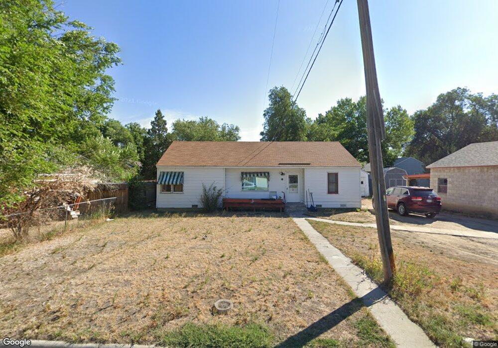
11 Marshall Dr Billings, MT 59101
South Central Billings NeighborhoodEstimated Value: $262,000 - $273,000
3
Beds
1
Bath
1,108
Sq Ft
$241/Sq Ft
Est. Value
About This Home
This home is located at 11 Marshall Dr, Billings, MT 59101 and is currently estimated at $266,530, approximately $240 per square foot. 11 Marshall Dr is a home located in Yellowstone County with nearby schools including Newman School, Riverside Junior High School, and Billings West High School.
Ownership History
Date
Name
Owned For
Owner Type
Purchase Details
Closed on
May 17, 2022
Sold by
Brents Catherine J and Brents Karen M
Bought by
Mueller Kelly
Current Estimated Value
Home Financials for this Owner
Home Financials are based on the most recent Mortgage that was taken out on this home.
Original Mortgage
$235,653
Outstanding Balance
$222,269
Interest Rate
4.81%
Mortgage Type
FHA
Estimated Equity
$44,261
Purchase Details
Closed on
Sep 25, 2018
Sold by
Brent Cathrine J
Bought by
Brents Catherine J and Brents Karen M
Purchase Details
Closed on
Jul 18, 2018
Sold by
Brents Karen M
Bought by
Brents Catherine J
Purchase Details
Closed on
Oct 25, 2010
Sold by
Mazurek Susan V
Bought by
Brents Catherine J and Brents Karen M
Home Financials for this Owner
Home Financials are based on the most recent Mortgage that was taken out on this home.
Original Mortgage
$113,471
Interest Rate
4.25%
Mortgage Type
FHA
Create a Home Valuation Report for This Property
The Home Valuation Report is an in-depth analysis detailing your home's value as well as a comparison with similar homes in the area
Home Values in the Area
Average Home Value in this Area
Purchase History
| Date | Buyer | Sale Price | Title Company |
|---|---|---|---|
| Mueller Kelly | -- | First Montana Title Company | |
| Brents Catherine J | -- | -- | |
| Brents Catherine J | -- | -- | |
| Brents Catherine J | -- | None Available |
Source: Public Records
Mortgage History
| Date | Status | Borrower | Loan Amount |
|---|---|---|---|
| Open | Mueller Kelly | $235,653 | |
| Previous Owner | Brents Catherine J | $113,471 | |
| Previous Owner | Brents Catherine J | $7,279 |
Source: Public Records
Tax History
| Year | Tax Paid | Tax Assessment Tax Assessment Total Assessment is a certain percentage of the fair market value that is determined by local assessors to be the total taxable value of land and additions on the property. | Land | Improvement |
|---|---|---|---|---|
| 2025 | $2,243 | $259,500 | $40,396 | $219,104 |
| 2024 | $2,243 | $219,600 | $39,980 | $179,620 |
| 2023 | $2,200 | $219,600 | $39,980 | $179,620 |
| 2022 | $2,082 | $186,000 | $0 | $0 |
| 2021 | $1,984 | $186,000 | $0 | $0 |
| 2020 | $2,031 | $182,100 | $0 | $0 |
| 2019 | $1,938 | $182,100 | $0 | $0 |
| 2018 | $1,829 | $168,500 | $0 | $0 |
| 2017 | $1,761 | $166,700 | $0 | $0 |
| 2016 | $1,489 | $140,600 | $0 | $0 |
| 2015 | $1,464 | $140,600 | $0 | $0 |
| 2014 | $1,361 | $69,165 | $0 | $0 |
Source: Public Records
Map
Nearby Homes
- 336 Foster Ln
- 226 Moore Ln
- 1204 Eldorado Dr
- 4642 Mitchell Ave
- 5327 Frontier Dr Unit 2
- 307 S Billings Blvd Unit 24
- 307 S Billings Blvd Unit 36
- 43 Prickett Ln
- 4531 Phillip St
- 1315 Cook Ave
- 1245 Cook Ave
- 117 Birchwood Dr
- 2203 George St
- 2155 Pueblo Dr
- 15 S Crestwood Dr
- 16 19th St W
- 5255 Golden Hollow Rd
- 5343 Golden Hollow Rd
- 5233 Golden Hollow Rd
- 1120 Miles Ave
- 33 Berg Ave
- 42 Macarthur Ave
- 31 Berg Ave
- 40 Macarthur Ave
- 40 Mac Arthur Ave
- 38 Macarthur Ave
- 12 Marshall Dr
- 10 Marshall Dr
- 14 Marshall Dr
- 27 Berg Ave
- 8 Marshall Dr
- 36 Macarthur Ave
- 16 Marshall Dr
- 34 Berg Ave
- 30 Berg Ave
- 41 Macarthur Ave
- 43 Macarthur Ave
- 6 Marshall Dr
- 39 Mac Arthur Ave
- 39 Macarthur Ave
Your Personal Tour Guide
Ask me questions while you tour the home.