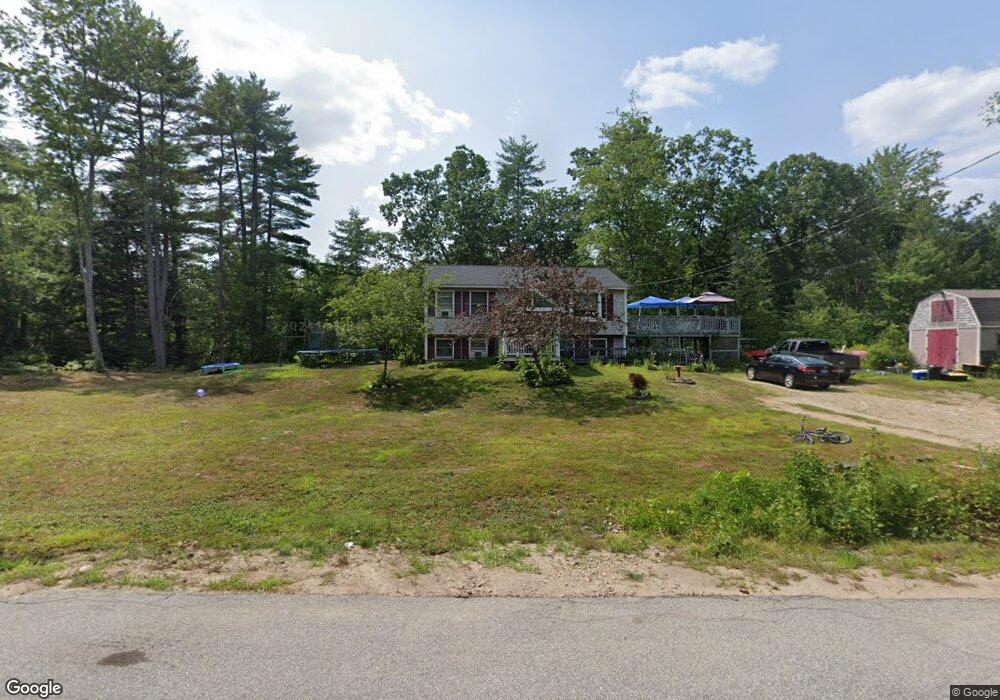
11 Tamarack Ln Raymond, NH 03077
Estimated Value: $406,000 - $446,000
2
Beds
1
Bath
864
Sq Ft
$490/Sq Ft
Est. Value
About This Home
This home is located at 11 Tamarack Ln, Raymond, NH 03077 and is currently estimated at $423,516, approximately $490 per square foot. 11 Tamarack Ln is a home located in Rockingham County with nearby schools including Lamprey River Elementary School, Iber Holmes Gove Middle School, and Raymond High School.
Ownership History
Date
Name
Owned For
Owner Type
Purchase Details
Closed on
May 29, 2002
Sold by
Bwc Realty Invests Llc
Bought by
Macdonald John W and Macdonald Carol A
Current Estimated Value
Home Financials for this Owner
Home Financials are based on the most recent Mortgage that was taken out on this home.
Original Mortgage
$146,400
Interest Rate
7%
Purchase Details
Closed on
Apr 3, 2002
Sold by
Burke Joseph T and Burke Sheila R
Bought by
Bwc Realty Invsts Llc
Home Financials for this Owner
Home Financials are based on the most recent Mortgage that was taken out on this home.
Original Mortgage
$146,400
Interest Rate
7%
Create a Home Valuation Report for This Property
The Home Valuation Report is an in-depth analysis detailing your home's value as well as a comparison with similar homes in the area
Home Values in the Area
Average Home Value in this Area
Purchase History
| Date | Buyer | Sale Price | Title Company |
|---|---|---|---|
| Macdonald John W | $184,000 | -- | |
| Bwc Realty Invsts Llc | $136,600 | -- |
Source: Public Records
Mortgage History
| Date | Status | Borrower | Loan Amount |
|---|---|---|---|
| Open | Bwc Realty Invsts Llc | $127,700 | |
| Closed | Bwc Realty Invsts Llc | $146,400 | |
| Previous Owner | Bwc Realty Invsts Llc | $101,000 |
Source: Public Records
Tax History Compared to Growth
Tax History
| Year | Tax Paid | Tax Assessment Tax Assessment Total Assessment is a certain percentage of the fair market value that is determined by local assessors to be the total taxable value of land and additions on the property. | Land | Improvement |
|---|---|---|---|---|
| 2024 | $5,878 | $268,300 | $118,200 | $150,100 |
| 2023 | $5,559 | $268,300 | $118,200 | $150,100 |
| 2022 | $4,907 | $268,300 | $118,200 | $150,100 |
| 2021 | $4,966 | $268,300 | $118,200 | $150,100 |
| 2020 | $5,264 | $200,900 | $84,700 | $116,200 |
| 2019 | $5,342 | $200,900 | $84,700 | $116,200 |
| 2018 | $5,294 | $200,900 | $84,700 | $116,200 |
| 2017 | $4,862 | $200,900 | $84,700 | $116,200 |
| 2016 | $4,769 | $200,900 | $84,700 | $116,200 |
| 2015 | $4,514 | $180,000 | $84,700 | $95,300 |
| 2014 | $4,379 | $180,000 | $84,700 | $95,300 |
| 2013 | $4,172 | $176,500 | $84,700 | $91,800 |
Source: Public Records
Map
Nearby Homes
- 7 Blaisdell Ct
- 6 Blaisdell Ct
- 17 Blaisdell
- 13 Bald Hill Rd
- 15 Bald Hill Rd
- 7 Bald Hill Rd
- 19 Bald Hill Rd
- 297 Crowley Rd
- 0 Lane Rd Unit 39
- 50 Blackstone Dr
- 118 Birch Rd
- 226 Villager Rd
- 249 Villager Rd
- 335 Raymond Rd
- 00 Dump Rd Unit 20
- 0 Eastside Dr Unit 33
- 11 Towle Rd
- Lot 2 Robin Way Unit 2
- Lot 7 Robin Way Unit 7
- 4 Coolidge Way