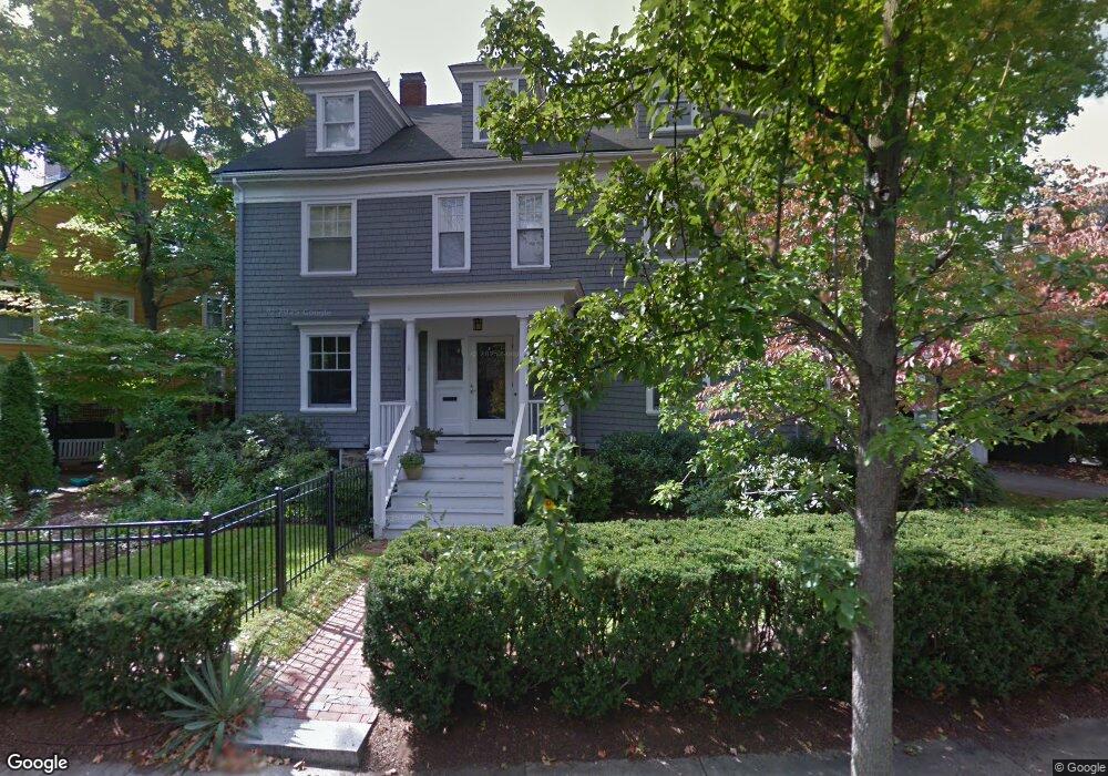
11 Traill St Cambridge, MA 02138
West Cambridge NeighborhoodEstimated Value: $4,771,464 - $6,966,000
6
Beds
5
Baths
4,740
Sq Ft
$1,211/Sq Ft
Est. Value
About This Home
This home is located at 11 Traill St, Cambridge, MA 02138 and is currently estimated at $5,740,866, approximately $1,211 per square foot. 11 Traill St is a home located in Middlesex County with nearby schools including Buckingham Browne & Nichols School, Shady Hill School, and St Peter School.
Ownership History
Date
Name
Owned For
Owner Type
Purchase Details
Closed on
Mar 21, 2008
Sold by
Thompson Kate F
Bought by
Barrozo Marco
Current Estimated Value
Home Financials for this Owner
Home Financials are based on the most recent Mortgage that was taken out on this home.
Original Mortgage
$1,900,000
Outstanding Balance
$1,184,306
Interest Rate
5.75%
Mortgage Type
Purchase Money Mortgage
Estimated Equity
$4,556,560
Purchase Details
Closed on
Feb 25, 1994
Sold by
Est Conquest Barbara S and Rogers Barbara J
Bought by
Thompson Kate F and Calano Daniel
Create a Home Valuation Report for This Property
The Home Valuation Report is an in-depth analysis detailing your home's value as well as a comparison with similar homes in the area
Home Values in the Area
Average Home Value in this Area
Purchase History
| Date | Buyer | Sale Price | Title Company |
|---|---|---|---|
| Barrozo Marco | $2,675,000 | -- | |
| Thompson Kate F | $535,000 | -- |
Source: Public Records
Mortgage History
| Date | Status | Borrower | Loan Amount |
|---|---|---|---|
| Open | Thompson Kate F | $1,000,000 | |
| Open | Barrozo Marco | $1,900,000 | |
| Previous Owner | Thompson Kate F | $150,000 | |
| Previous Owner | Thompson Kate F | $50,000 |
Source: Public Records
Tax History
| Year | Tax Paid | Tax Assessment Tax Assessment Total Assessment is a certain percentage of the fair market value that is determined by local assessors to be the total taxable value of land and additions on the property. | Land | Improvement |
|---|---|---|---|---|
| 2025 | $33,164 | $5,222,700 | $2,229,600 | $2,993,100 |
| 2024 | $29,820 | $5,037,200 | $2,211,700 | $2,825,500 |
| 2023 | $27,173 | $4,637,100 | $2,202,700 | $2,434,400 |
| 2022 | $25,179 | $4,253,200 | $2,122,900 | $2,130,300 |
| 2021 | $23,376 | $3,995,900 | $2,083,200 | $1,912,700 |
| 2020 | $21,884 | $3,805,900 | $1,993,700 | $1,812,200 |
| 2019 | $19,706 | $3,317,500 | $1,679,400 | $1,638,100 |
| 2018 | $20,431 | $3,248,200 | $1,670,700 | $1,577,500 |
| 2017 | $19,916 | $3,068,700 | $1,593,200 | $1,475,500 |
| 2016 | $19,045 | $2,724,600 | $1,377,900 | $1,346,700 |
| 2015 | $19,537 | $2,498,400 | $1,291,800 | $1,206,600 |
| 2014 | $20,510 | $2,447,500 | $1,257,400 | $1,190,100 |
Source: Public Records
Map
Nearby Homes
- 172 Brattle St
- 159 Brattle St
- 157 Brattle St
- 153 Brattle St
- 1010 Memorial Dr Unit 6F
- 117 Lexington Ave Unit 117
- 497 Mount Auburn St
- 119 Appleton St
- 59-61 Reservoir St Unit 2
- 65 Fresh Pond Pkwy
- 46 Foster St
- 35 Willard St
- 180 Larch Rd
- 3 Berkeley Place
- 252 Lexington Ave Unit 2
- 252 Lexington Ave Unit 4
- 252 Lexington Ave Unit 1
- 252 Lexington Ave Unit 3
- 133 Fayerweather St Unit 133
- 316 Concord Ave
- 14 Elmwood Ave
- 3 Traill St Unit D
- 20 Elmwood Ave
- 17 Traill St
- 12 Traill St
- 8 Traill St
- 6 Elmwood Ave
- 6 Elmwood Ave Unit 6
- 6 Elmwood Ave Unit Ave
- 16 Traill St
- 10 Traill St
- 26 Elmwood Ave
- 371 Mount Auburn St
- 369 Mount Auburn St
- 365 Mount Auburn St
- 361 Mount Auburn St Unit 2
- 361 Mount Auburn St Unit 1
- 361 Mt Auburn St Unit 2
- 375 Unit 1
- 375 Unit 2
Your Personal Tour Guide
Ask me questions while you tour the home.